

Winnipeg (Man.). West End
Taxonomy
Code
Scope note(s)
- Encompasses the area of Winnipeg north of the Assiniboine River, west of the Isabel-Balmoral-Memorial-Osborne corridor, south of the Canadian Pacific Railway tracks, and east of the former City of St. James-Assiniboia.
Source note(s)
Display note(s)
Hierarchical terms
Winnipeg (Man.). West End
Equivalent terms
Winnipeg (Man.). West End
- UF Manitoba--Winnipeg--West End
- UF West End
Associated terms
Winnipeg (Man.). West End
259 archival descriptions results for Winnipeg (Man.). West End
259 results directly related Exclude narrower terms
Aerial view of Winnipeg looking south on Memorial Boulevard toward Legislative Building
- i01422
- Item
- 1935
Date of photograph is approximate, ca. 1935.
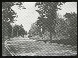
Assiniboine Avenue at Armstrong’s Point
- i04547
- Item
- [ca. 1912]
Part of Morris Block collection
Photograph of a horse-drawn cart on Assiniboine Avenue near Armstrong Point, possibly what is now the Cornish Path.
Block, Morris
- i00827
- Item
- 1950
Part of City of Winnipeg (1874-1971)
A photograph taken during the 1950 flood, showing between 39 and 51 Eastgate. Item is 1 of 2 photographs on page 98 of scrapbook.
Harold K. White Studio

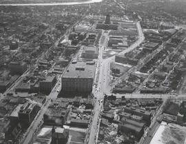
Central Business District: Aerial view - Central Winnipeg
- i01464
- Item
- 1947
Date of photograph is approximate, ca. 1947.
![Central Winnipeg between Portage and Notre Dame Avenues [Aerial view]](/uploads/r/city-of-winnipeg-archives-amp-records-control-branch/e/3/f/e3f90f80ff2b9d7dc2938509d7f4a5b4dfdfef9308ecfc0cfa38d5f1e2aa0bb8/C0013_0000_0000_P0018_0026_001_142.jpg)
Central Winnipeg between Portage and Notre Dame Avenues [Aerial view]
- i01910
- Item
- 1942
Inscription (on recto): WG A158 8/6/1942 Central Wpg between Portage and Notre Dame Ave's.
![C.P.R. Yards looking West [Aerial view]](/uploads/r/city-of-winnipeg-archives-amp-records-control-branch/1/d/2/1d24b0471a50903dd76276838a7e169e4890a17020a9cfe6a0d34e153ebb9ec9/C0013_0000_0000_P0018_0027_001_142.jpg)
C.P.R. Yards looking West [Aerial view]
- i01911
- Item
- 1942
Inscription (on recto): WG A114 30-2-42 CPR [Canadian Pacific Railway] RR [Railroad] Yards looking West.
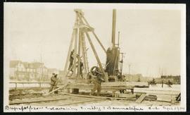
Excavation at Emily and Bannatyne
- i04400
- Item
- Apr. 1914
Part of Morris Block collection
Block, Morris
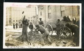
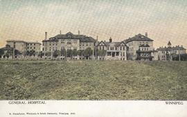
Excavation on Bannatyne near General Hospital
- i04432
- Item
- Apr. 1914
Part of Morris Block collection
Block, Morris
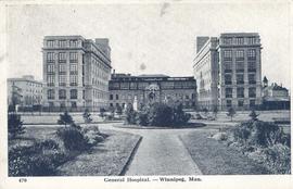
General Hospital - Winnipeg, Man.
- i01996
- Item
- [ca. 1949]
Item consists of a postcard in printed format that shows the Winnipeg General Hospital. Date of postcard is unknown.
- i01713
- Item
- 1907
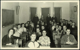
Jon Bjarnason Academy – grade 12 class and faculty
- i04033
- Item
- [1937 or 1938]
Group photograph of the 1937-38 grade 12 class at Jon Bjarnason Academy (652 Home Street), seated in their desks with faculty standing behind them.
![Legislative Building and Central Winnipeg [Aerial view]](/uploads/r/city-of-winnipeg-archives-amp-records-control-branch/5/1/1/511af88a9e92fe7d7d3edda2bdaee6fc5652013532efb88411d3403dfcf85917/C0013_0000_0000_P0018_0046_001_142.jpg)
Legislative Building and Central Winnipeg [Aerial view]
- i01932
- Item
- 1945
Inscription (on recto): WG M35: 4-5, 5 Mar '45, Legislative Bldg and Central Wpg, appr. scale 1/12000.
![Logan Avenue and Salter Street [Aerial view]](/uploads/r/city-of-winnipeg-archives-amp-records-control-branch/9/8/0/980f8ba4214d821c9b49366ae35d9ea9ed5b7f44366c5cd894e04befdd6c7a22/C0013_0000_0000_P0018_0033_001_142.jpg)
Logan Avenue and Salter Street [Aerial view]
- i01918
- Item
- 1943
Inscription (on recto): A161 3-9-43 Logan Ave and Salter St Wp [Winnipeg?] about 4000' 5".
- i00853
- Item
- 1950
Part of City of Winnipeg (1874-1971)
A photograph taken during the 1950 flood, showing looking south on Eastgate. Item is 1 of 2 photographs on page 110 of scrapbook.
Harold K. White Studio
- i00835
- Item
- 1950
Part of City of Winnipeg (1874-1971)
A photograph taken during the 1950 flood, showing looking south on Middlegate. Item is 1 of 2 photographs on page 102 of scrapbook.
Harold K. White Studio
- i00845
- Item
- 1950
Part of City of Winnipeg (1874-1971)
A photograph taken during the 1950 flood, showing looking south on Westgate. Item is 1 of 2 photographs on page 107 of scrapbook.
Harold K. White Studio
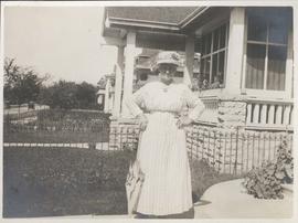

New boulevards on street north from Palmerston Avenue.
- i03990
- Item
- [ca. 1920]
View of new boulevards on an unidentified street in the Wolseley area, facing north from Palmerston Avenue.
![Northwest Winnipeg [Aerial view]](/uploads/r/city-of-winnipeg-archives-amp-records-control-branch/4/f/3/4f37bff68f08b53a6e7296217f26c266711570595702620b7b89d115744d09e4/C0013_0000_0000_P0018_0025_001_142.jpg)
Northwest Winnipeg [Aerial view]
- i01909
- Item
- 1941
Aerial view of the Minto area. Inscription (on recto): WG A90 '41, 1941 - Northwest Winnipeg.
Results 41 to 60 of 259