
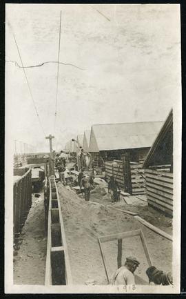
Work being done at Union Stock Yards
- i04377
- Pièce
- 1913
Fait partie de Morris Block collection
Sans titre
70 résultats directement liés Exclure les termes spécifiques
Work being done at Union Stock Yards
Fait partie de Morris Block collection
Sans titre
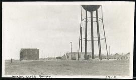
Buildings and water tower of Union Stock Yards
Fait partie de Morris Block collection
Sans titre

View looking west over Red River into downtown Winnipeg from St. Boniface
Fait partie de City of Winnipeg Archives Photograph collection
Photograph shows view of downtown Winnipeg, between Notre Dame Avenue East (Pioneer Avenue) and Lombard Avenue. Barge on the Red River also appears in photograph. Date of photograph is approximate, ca. 1930.
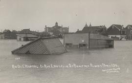
Rue De L'Hopital et Rue Langevin, St. Boniface Floods, April 1916
Fait partie de City of Winnipeg Archives Photograph collection
Postcard is a photographic print showing water flooding homes and other structures. Photograph taken by Advance Photo Company, Winnipeg. Azo mark appears in stamp box, made in Canada.

1950 Flood - Flood Evacuees at the St. Boniface train station
Fait partie de City of Winnipeg Archives Photograph collection
A Short, Pictorial Documentary on the Winnipeg Flood of 1950
Sans titre

St. Boniface Basilica and the Assumption Monument
Fait partie de City of Winnipeg Archives Photograph collection
Photograph shows St. Boniface Basilica in background. The Assumption (monument) commemorating the saving of St. Boniface from the 1950 flood shown in foreground.

Man in boat rowing down residential street, 1916 Flood, Norwood
Fait partie de City of Winnipeg Archives Photograph collection
Photograph shows scene from the 1916 flooding of the Assiniboine River in Norwood, unidentified man rowing down residential street at center-left of photograph.

Aerial view of Point Douglas, St. Boniface, and Elmwood areas
Fait partie de City of Winnipeg Archives Photograph collection
Aerial photograph of Point Douglas, St. Boniface, and west Elmwood.

Southdale Shopping Centre panorama
Fait partie de City of Winnipeg Archives Photograph collection
View of Southdale Shopping Centre, 35 Lakewood Boulevard, 12.8 acres. From left to right: Dominion Store, Canadian Imperial Bank of Commerce, Mall Entrance, Quintons, Ebbeling Pharmacy, Kmart Department Store. Consists of 3 separate photographs pasted together on cardboard to create a panorama. The cardboard is a scrap made from an old sign of the Metropolitan Corporation of Greater Winnipeg (visible on the reverse). The cardboard is numbered “5”, presumably as part of a compilation with other shopping centre panoramas.
Sans titre

Waghorn's Guide map and street index
Fait partie de City Clerk's Library collection
Waghorn's Guide - a small promotional pamphlet published by J.R. Waghorn in 1895. The pamphlet contains a street map of Winnipeg, a street index, and advertisements for various Winnipeg businesses including the Clarendon Hotel, the Redwood Brewery, and the Massey-Harris Company. The map shows the old City of Winnipeg from the Red River on the east to Waverly, Aubrey, and McPhillips Streets on the west, and from Athole Avenue (now Luxton Avenue) in the north to Parker Avenue in the south. Southern Elmwood, Old St. Boniface, and Norwood are also shown on the east side of the river. Railway lines are in black and electric street railway lines are in red.