Title and statement of responsibility area
Title proper
Waghorn's Guide map and street index
General material designation
- Cartographic material
- Textual record
Parallel title
Other title information
Title statements of responsibility
Title notes
Level of description
Item
Repository
Reference code
Edition area
Edition statement
Edition statement of responsibility
Class of material specific details area
Statement of scale (cartographic)
Statement of projection (cartographic)
Statement of coordinates (cartographic)
Statement of scale (architectural)
Issuing jurisdiction and denomination (philatelic)
Dates of creation area
Date(s)
-
1895 (Creation)
Physical description area
Physical description
1 pamphlet
Publisher's series area
Title proper of publisher's series
Parallel titles of publisher's series
Other title information of publisher's series
Statement of responsibility relating to publisher's series
Numbering within publisher's series
Note on publisher's series
Archival description area
Custodial history
Scope and content
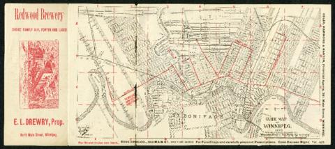
Waghorn's Guide - a small promotional pamphlet published by J.R. Waghorn in 1895. The pamphlet contains a street map of Winnipeg, a street index, and advertisements for various Winnipeg businesses including the Clarendon Hotel, the Redwood Brewery, and the Massey-Harris Company. The map shows the old City of Winnipeg from the Red River on the east to Waverly, Aubrey, and McPhillips Streets on the west, and from Athole Avenue (now Luxton Avenue) in the north to Parker Avenue in the south. Southern Elmwood, Old St. Boniface, and Norwood are also shown on the east side of the river. Railway lines are in black and electric street railway lines are in red.
Notes area
Physical condition
Immediate source of acquisition
Arrangement
Language of material
Script of material
Location of originals
Availability of other formats
Restrictions on access
There are no restrictions on access to this record.
Terms governing use, reproduction, and publication
Copyright: public domain


