
- d00994
- File
- 2008-2013
Part of The W.R.E.N.C.H. Winnipeg Cycling Archive collection
Bike to Work Day Winnipeg
33 results directly related Exclude narrower terms
Part of The W.R.E.N.C.H. Winnipeg Cycling Archive collection
Bike to Work Day Winnipeg

Rossmere Shopping Centre panorama
View of Rossmere Shopping Centre, 1070 Henderson Highway, southwest corner Rowandale, 4.25 acres. From left to right: a garage or car wash, Red River Co-Op Store, Rossmere Lanes Bowling Alley, Library, Dry Cleaners, Co-operators Credit Union Society Limited, Rowandale Baptist Church, Rowandale Apartments, Red River Co-Op Gas Station. Consists of 3 separate photographs pasted together on cardboard to create a panorama. The cardboard is a scrap made from an old sign of the Metropolitan Corporation of Greater Winnipeg (visible on the reverse). The cardboard is numbered “2”, presumably as part of a compilation with other shopping centre panoramas.
Metropolitan Corporation of Greater Winnipeg (Man.). Planning Division
Scanned 1970s reports and maps
Part of The W.R.E.N.C.H. Winnipeg Cycling Archive collection
Winnipeg (Man.)

Scrapbook of Corporal Wallace – page 2
Page 2 of a photograph scrapbook made by Corporal John Wallace in April 1940. Photos consist of Portage Avenue looking west from around Vaughn Street, a rail line at Portage Avenue and St. James Street, troops in formation, and Mrs. and Shirley Gardiner. See general notes section for more details.
Wallace, John

Scrapbook of Corporal Wallace – page 9
Page 9 of a photograph scrapbook made by Corporal John Wallace in April 1940. Photographs depict a street in Gladstone Manitoba, a trolley bus in Winnipeg on Kennedy Street (between Ellice and Qu'Appelle), and the Butler family, acquaintances of Wallace. See page three of this scrapbook for more details on the Butler family.
Wallace, John
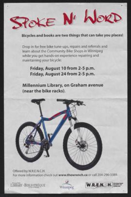
Part of The W.R.E.N.C.H. Winnipeg Cycling Archive collection
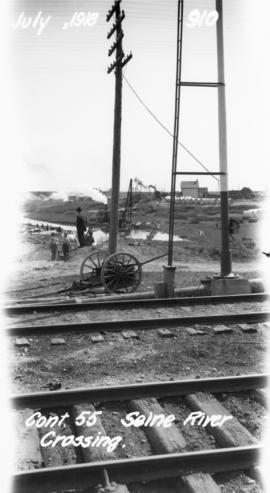
Photograph of the Seine River crossing of the Winnipeg Aqueduct, taken from the Canadian Northern Railway tracks north of Provencher Boulevard and looking northeast towards Rue Notre Dame. Photographer is unknown.
Greater Winnipeg Water District
Date of postcard is uncertain, [before 1949].
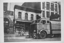
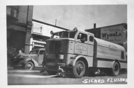
Sicard Flusher, Market Street - May 1948
Star Hotel, Market Café, Dirkfield's Novelty Mfg. shown in background of photograph.
Part of The W.R.E.N.C.H. Winnipeg Cycling Archive collection
The W.R.E.N.C.H.
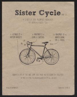
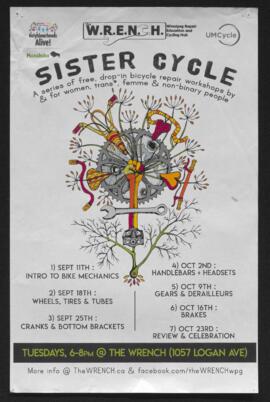
Sister Cycle workshop series poster
Part of The W.R.E.N.C.H. Winnipeg Cycling Archive collection
The W.R.E.N.C.H.

Part of The W.R.E.N.C.H. Winnipeg Cycling Archive collection
The W.R.E.N.C.H.
Part of The W.R.E.N.C.H. Winnipeg Cycling Archive collection
Adverts for Critical Mass affiliated social events.
Critical Mass Winnipeg

Southdale Shopping Centre panorama
View of Southdale Shopping Centre, 35 Lakewood Boulevard, 12.8 acres. From left to right: Dominion Store, Canadian Imperial Bank of Commerce, Mall Entrance, Quintons, Ebbeling Pharmacy, Kmart Department Store. Consists of 3 separate photographs pasted together on cardboard to create a panorama. The cardboard is a scrap made from an old sign of the Metropolitan Corporation of Greater Winnipeg (visible on the reverse). The cardboard is numbered “5”, presumably as part of a compilation with other shopping centre panoramas.
Metropolitan Corporation of Greater Winnipeg (Man.). Planning Division
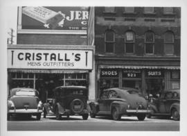
Southeast corner of back lane, north side of Market Avenue and Main Street, circa 1941
Photograph shows present site of the Centennial Concert Hall. Cristall's Mens Outfitters visible in photograph.

Southgate Shopping Centre panorama
View of Southgate Village Shopping Centre, 1305-1341 Pembina Highway at the southwest corner of McGillivray Boulevard, 3.3 acres. From left to right: Pembina Curling Rink, Imperial Cleaners, Safeway, The Place, Young Togs, Reid Marshall Pharmacy, The Village Gift Shop, The French Salon, Marshall Wells, The Toronto Dominion Bank, Safeway gas bar. Consists of 3 separate photographs pasted together on cardboard to create a panorama. The cardboard is a scrap made from an old sign of the Metropolitan Corporation of Greater Winnipeg (visible on the reverse). The cardboard is numbered “7”, presumably as part of a compilation with other shopping centre panoramas.
Metropolitan Corporation of Greater Winnipeg (Man.). Planning Division
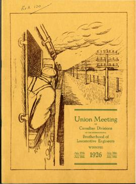
Souvenir Programme of Brotherhood of Locomotive Engineers meeting
Part of City of Winnipeg (1874-1971)
A promotional souvenir programme of the 1926 union meeting of the Canadian Divisions of the International Brotherhood of Locomotive Engineers, held in Winnipeg on July 27-30, 1926. Booklet contains promotional information about and histories of the union, photographs of and statements made by union members and local politicians, and advertisements.
Winnipeg (Man.). Committee on Legislation and Reception
Part of The W.R.E.N.C.H. Winnipeg Cycling Archive collection
The W.R.E.N.C.H.
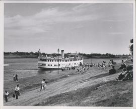
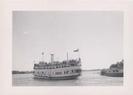
S.S. Keenora with crowds of people on deck
Stamp (on verso): Taylor Made Service Process, July 11 ????. Date of photograph is uncertain, [192-?].