
- d00373
- Dossier
- [ca. 1920], 1989
Fait partie de Parks and Recreation Photograph collection
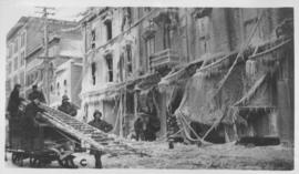
Photographs of boulevards around Winnipeg, some new, others damaged.
145 résultats directement liés Exclure les termes spécifiques
Fait partie de Parks and Recreation Photograph collection
Photographs of boulevards around Winnipeg, some new, others damaged.
The "Blue Store," Main Street, Winnipeg after fire - January 25, 1918
Fait partie de City of Winnipeg Archives Photograph collection

The Cove Restaurant, corner of Portage and Carlton
Fait partie de City of Winnipeg Archives Photograph collection
Photograph of "The Cove" Restaurant at 355 Portage Avenue, at Carlton Street. The photograph was taken from a building on Carlton Street looking southeast towards the Eaton's Building, Mitchell-Copp, Zeller's, and the Carlton Building.
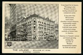
The Leland Hotel, William at King
Fait partie de City of Winnipeg Archives Photograph collection
Postcard shows Leland Hotel at William Avenue and King Street. Date of postcard is uncertain [before 1949].

Thoroughfares: Academy Road at Wellington Crescent
Fait partie de City of Winnipeg Archives Photograph collection
View of cars and cyclists heading down Academy Road towards Wellington Crescent and the Maryland Bridge. The cupola of Misericordia Hospital can be seen across the bridge.

Thoroughfares: Academy Road at Wellington Crescent
Fait partie de City of Winnipeg Archives Photograph collection
View of cars and cyclists heading down Academy Road towards Wellington Crescent and the Maryland Bridge. A small portion of Misericordia Hospital can be seen across the bridge.
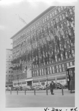
VE Day in Winnipeg showing Eaton's Building on Portage Avenue adorned with flags
Fait partie de City of Winnipeg Archives Photograph collection
Photograph shows Victory in Europe Day (VE Day) celebrations marking the end of World War 2 in Europe.
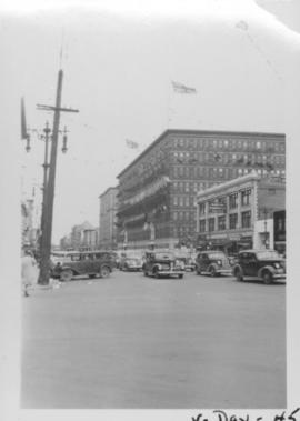
VE Day in Winnipeg showing Portage Avenue and Eaton's building in background
Fait partie de City of Winnipeg Archives Photograph collection
Photograph shows Victory in Europe Day (VE Day) celebrations marking the end of World War 2 in Europe.
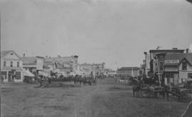
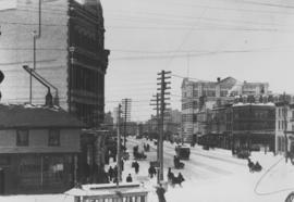
View of Main Street looking north
Fait partie de City of Winnipeg Archives Photograph collection
City of Winnipeg businesses shown in photograph: George Ashdown Hardware, Davis House, Symonds Furrier, Gable Hotel, J. Lister, Outfitter, Rossin House, the Blue Store, and the first City Hall is shown in background.
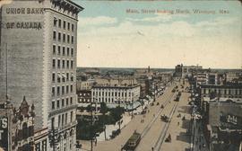
View of Main Street looking north from the Western Canada Loan Building
Fait partie de City of Winnipeg Archives Photograph collection
Photograph shows view of Main Street looking north from the roof of the Western Canada Loan Building, 392 Main Street at Portage Avenue. Date of photograph is approximate, ca. 1935.

View of Main Street south from Higgins showing Alberta Hotel
Fait partie de City of Winnipeg Archives Photograph collection
Date of photograph is uncertain, [before 1949].

View of Main Street south from Higgins showing Alberta Hotel and Nugget Hotel
Fait partie de City of Winnipeg Archives Photograph collection
Date of photograph is uncertain, [before 1949].
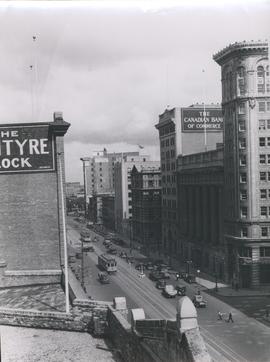
View of Notre Dame Avenue looking east from Kate Street
Fait partie de City of Winnipeg Archives Photograph collection
Photograph shows Notre Dame Avenue looking east from Kate Street toward Lindsay Building at 228 Notre Dame Avenue. Businesses appearing in photograph include Green Orchard Lunch, 551 Notre Dame Avenue, and B - A Service Station. Date of photograph is approximate, ca. 1939.

Waghorn's Guide map and street index
Fait partie de City Clerk's Library collection
Waghorn's Guide - a small promotional pamphlet published by J.R. Waghorn in 1895. The pamphlet contains a street map of Winnipeg, a street index, and advertisements for various Winnipeg businesses including the Clarendon Hotel, the Redwood Brewery, and the Massey-Harris Company. The map shows the old City of Winnipeg from the Red River on the east to Waverly, Aubrey, and McPhillips Streets on the west, and from Athole Avenue (now Luxton Avenue) in the north to Parker Avenue in the south. Southern Elmwood, Old St. Boniface, and Norwood are also shown on the east side of the river. Railway lines are in black and electric street railway lines are in red.
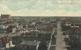
Fait partie de City of Winnipeg Archives Photograph collection
Postcard shows a view of Winnipeg from the Court House. Published by Valentine & Sons' Publishing Co. Ltd. Montreal and Toronto. Printed in Great Britain. Date of postcard is uncertain.

Fait partie de City of Winnipeg (1874-1971)
Photograph of the Winnipeg Renovating Co. and the Grain Exchange on Lombard Avenue. Item is part of small album containing photographs of maps tracking the outbreak of typhoid from 1905 to 1908 and other scenes. Item is loose and at back of album. Date of item is approximate, [circa 1909].

Fait partie de City of Winnipeg (1874-1971)
Photograph of the Winnipeg Renovating Co. on Lombard Avenue. Item is part of small album containing photographs of maps tracking the outbreak of typhoid from 1905 to 1908 and other scenes. Item is loose and at back of album. Date of item is approximate, [circa 1909].

Winnipeg Street Railway on Portage Avenue in front of Merchants Hotel
Fait partie de City of Winnipeg Archives Photograph collection
Winnipeg Street Railway on Portage Avenue in front of Merchants Hotel
Fait partie de City of Winnipeg Archives Photograph collection