
- i00793
- Item
- 1950
Part of City of Winnipeg (1874-1971)
A photograph taken during the 1950 flood, showing Wellington by Maryland Bridge. Item is 1 of 8 photographs on page 90 of scrapbook.
Harold K. White Studio
28 results with digital objects Show results with digital objects
Part of City of Winnipeg (1874-1971)
A photograph taken during the 1950 flood, showing Wellington by Maryland Bridge. Item is 1 of 8 photographs on page 90 of scrapbook.
Harold K. White Studio

Waghorn's Guide map and street index
Part of City Clerk's Library collection
Waghorn's Guide - a small promotional pamphlet published by J.R. Waghorn in 1895. The pamphlet contains a street map of Winnipeg, a street index, and advertisements for various Winnipeg businesses including the Clarendon Hotel, the Redwood Brewery, and the Massey-Harris Company. The map shows the old City of Winnipeg from the Red River on the east to Waverly, Aubrey, and McPhillips Streets on the west, and from Athole Avenue (now Luxton Avenue) in the north to Parker Avenue in the south. Southern Elmwood, Old St. Boniface, and Norwood are also shown on the east side of the river. Railway lines are in black and electric street railway lines are in red.
Under construction, Oakwood Street
Part of City of Winnipeg (1874-1971)
A photograph taken during the 1950 flood, showing Oakwood Street under construction. Item is 1 of 7 photographs on page 25 of scrapbook.
Harold K. White Studio

Thoroughfares: Academy Road at Wellington Crescent
View of cars and cyclists heading down Academy Road towards Wellington Crescent and the Maryland Bridge. The cupola of Misericordia Hospital can be seen across the bridge.

Thoroughfares: Academy Road at Wellington Crescent
View of cars and cyclists heading down Academy Road towards Wellington Crescent and the Maryland Bridge. A small portion of Misericordia Hospital can be seen across the bridge.
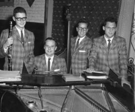
The Jose Poneira Quartet at The Rancho Don Carlos
Part of Owen Clark collection
Photograph shows the Jose Poneira Quartet at the Rancho Don Carlos. From left to right: Jimmy Weber, Jose Poneira, Jim Cordupel and Ed Sersen.
S.W. Corner Arnold & Mabel (62?)
Part of City of Winnipeg (1874-1971)
A photograph taken during the 1950 flood, showing the southwest corner of Arnold Avenue and Mabel Avenue and possibly 62 Arnold Avenue. Item is 8 of 8 photographs on page 1 of scrapbook.
Harold K. White Studio
Photographs of boulevards around Winnipeg, some new, others damaged.
S.E. Corner Arnold Avenue (100 Arnold?)
Part of City of Winnipeg (1874-1971)
A photograph taken during the 1950 flood, showing the southeast corner of Arnold Avenue and possibly 100 Arnold Avenue. Item is 7 of 8 photographs on page 1 of scrapbook.
Harold K. White Studio

Scrapbook of Corporal Wallace – page 9
Page 9 of a photograph scrapbook made by Corporal John Wallace in April 1940. Photographs depict a street in Gladstone Manitoba, a trolley bus in Winnipeg on Kennedy Street (between Ellice and Qu'Appelle), and the Butler family, acquaintances of Wallace. See page three of this scrapbook for more details on the Butler family.
Wallace, John
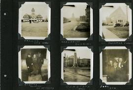
Scrapbook of Corporal Wallace – page 6
Page 6 of a photograph scrapbook made by Corporal John Wallace in April 1940. Photographs depict the Pavilion in City Park (Assiniboine Park), the Legislature Building off in the distance down Memorial Boulevard, St. Ignatius Church at Corydon Avenue and Stafford Street, the Winnipeg Cenotaph, and acquaintenances of Wallace, Mr. and Mrs. McCarthy and “Sister Sue”, and two people identified only as “Joan” and “Den”. See general notes section for more details.
Wallace, John
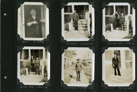
Scrapbook of Corporal Wallace – page 5
Page 5 of a photograph scrapbook made by Corporal John Wallace in April 1940. Photographs depict several acquaintenance of Wallace including two fellow soldiers, “Sonny” Robertson and Joseph “Fuss” McGrath, a Mrs. Penny, and a Frank Dowling and his family. See the general notes section for more details.
Wallace, John
Scrapbook [1950 flood photographs]
Part of City of Winnipeg (1874-1971)
Subseries consists of a scrapbook assembled by the City Engineering Department to serve as photographic evidence of the 1950 flood. It contains black and white photographs that mostly document flooding in residential areas near the Red River (Fort Rouge, Riverview, North End, Point Douglas, Crescentwood, Armstrong's Point and others). Scrapbook appears to be organized geographically by area and street. In addition to documenting flooding, the photographs provide a detailed record of residential neighbourhoods, houses, streets, and businesses like corner grocery stores and laundries. All photographs were taken by Harold K. White Studio.
Winnipeg (Man.). City Engineer

Part of Owen Clark collection
Group of musicians eating dinner at Don Carlos Casino with Johnny Bering standing in rear
Part of City of Winnipeg (1874-1971)
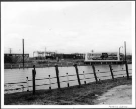
A photograph of a flooded underpass on Pembina Highway during the 1950 flood in Winnipeg.
Harold K. White Studio
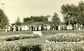
Photograph shows people gathered near a flower garden at Pembina Park (now known as Fisher Park). Date of photograph is 1938.
New house, 129, 133, 137, 143 and 145 Maplewood Avenue
Part of City of Winnipeg (1874-1971)
A photograph taken during the 1950 flood, showing 129 Maplewood Avenue and 133 Maplewood Avenue and 137 Maplewood Avenue and 143 Maplewood Avenue and 145 Maplewood Avenue. Item is 3 of 5 photographs on page 22 of scrapbook.
Harold K. White Studio
Negatives - 2 views ? Baltimore Road
Part of City of Winnipeg (1874-1971)
Negatives - 2 views ? Baltimore Road Item is 6 of 6 negatives on page 27 of scrapbook.
Harold K. White Studio
Part of City of Winnipeg (1874-1971)
A photograph taken during the 1950 flood, showing Morley Avenue Grocery located @ Morley and Fisher. Item is 2 of 8 photographs on page 11 of scrapbook.
Harold K. White Studio