
- d00335
- File
- 1940-1979
Winnipeg (Man.). South End
Taxonomy
Code
Scope note(s)
- Encompasses the area of the pre-Unicity City of Winnipeg south of the Assiniboine River and to the North and East of the former Town of Tuxedo and Rural Municipality of Fort Garry.
Source note(s)
Display note(s)
Hierarchical terms
Winnipeg (Man.). South End
Equivalent terms
Winnipeg (Man.). South End
- UF Manitoba--Winnipeg--South End
- UF South End
Associated terms
Winnipeg (Man.). South End
310 archival descriptions results for Winnipeg (Man.). South End
310 results directly related Exclude narrower terms

Aerial view of Riverview, St. Vital, and Wildwood
- i04017
- Item
- [194-]
Aerial view of the Riverview area of Fort Rouge, including Osborne Street; the Wildwood area of Fort Garry; and the Kingston Crescent, Elm Park, Varennes, St. George, and Glenlawn areas of St. Vital, including Kingston Row, St. Mary’s Road, and St. Anne’s Road.

Thoroughfares: Academy Road at Wellington Crescent
- i04020
- Item
- [194-?]
View of cars and cyclists heading down Academy Road towards Wellington Crescent and the Maryland Bridge. A small portion of Misericordia Hospital can be seen across the bridge.
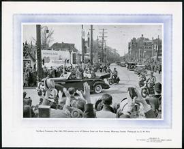
1939 Royal Procession at River and Osborne
- i04566
- Item
- 24 May 1939
Part of Morris Block collection
Photograph printed on cardboard of the corner of River Avenue and Osborne Street during the Royal Procession of Queen (then Princess) Elizabeth and King George on May 24, 1939.
Block, Morris
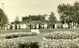
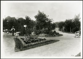
- i02973
- Item
- 1938
Photograph shows people gathered near a flower garden at Pembina Park (now known as Fisher Park). Date of photograph is 1938.
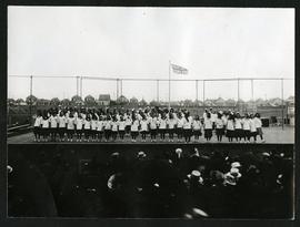
Girls on stage in Fort Rouge Park
- p00310
- Part
- [ca. 1930]
Photograph of a group of girls performing on a stage in front of an audience in Fort Rouge Park. Photograph is affixed to one side of an album page.
- d00373
- File
- [ca. 1920], 1989
Photographs of boulevards around Winnipeg, some new, others damaged.

- i03952
- Item
- 1913
Children's wading pool and park benches along a stone path in the Park.
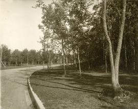
- p00309
- Part
- [ca. 1920]
A view of a path in Crescentwood Park affixed to one side of an album page. Photographed by Steele and Company.

- i03951
- Item
- 1908
Young trees planted in a grassy area intersected with stone paths. Caption: "Two Years Work".

Waghorn's Guide map and street index
- i04040
- Item
- 1895
Part of City Clerk's Library collection
Waghorn's Guide - a small promotional pamphlet published by J.R. Waghorn in 1895. The pamphlet contains a street map of Winnipeg, a street index, and advertisements for various Winnipeg businesses including the Clarendon Hotel, the Redwood Brewery, and the Massey-Harris Company. The map shows the old City of Winnipeg from the Red River on the east to Waverly, Aubrey, and McPhillips Streets on the west, and from Athole Avenue (now Luxton Avenue) in the north to Parker Avenue in the south. Southern Elmwood, Old St. Boniface, and Norwood are also shown on the east side of the river. Railway lines are in black and electric street railway lines are in red.
- i00760
- Item
- 1950
Part of City of Winnipeg (1874-1971)
A photograph taken during the 1950 flood, showing 192 Mayfair Avenue. Item is 1 of 6 photographs on page 85 of scrapbook.
Harold K. White Studio
- i00770
- Item
- 1950
Part of City of Winnipeg (1874-1971)
A photograph taken during the 1950 flood, showing 101 Mayfair Avenue. Item is 5 of 5 photographs on page 86 of scrapbook.
Harold K. White Studio
- i00771
- Item
- 1950
Part of City of Winnipeg (1874-1971)
A photograph taken during the 1950 flood, showing 228 River Avenue. Item is 1 of 8 photographs on page 87 of scrapbook.
Harold K. White Studio
- i00775
- Item
- 1950
Part of City of Winnipeg (1874-1971)
A photograph taken during the 1950 flood, showing 146 River Avenue and 148 River Avenue. Item is 5 of 8 photographs on page 87 of scrapbook.
Harold K. White Studio
- i00778
- Item
- 1950
Part of City of Winnipeg (1874-1971)
A photograph taken during the 1950 flood, showing 105 River Avenue. Item is 8 of 8 photographs on page 87 of scrapbook.
- i00780
- Item
- 1950
Part of City of Winnipeg (1874-1971)
A photograph taken during the 1950 flood, showing 205 River Avenue and 215 River Avenue. Item is 2 of 8 photographs on page 88 of scrapbook.
Harold K. White Studio
- i00791
- Item
- 1950
Part of City of Winnipeg (1874-1971)
A photograph taken during the 1950 flood, showing 141 Wellington Crescent. Item is 5 of 6 photographs on page 89 of scrapbook.
Harold K. White Studio
- i00793
- Item
- 1950
Part of City of Winnipeg (1874-1971)
A photograph taken during the 1950 flood, showing Wellington by Maryland Bridge. Item is 1 of 8 photographs on page 90 of scrapbook.
Harold K. White Studio
Results 21 to 40 of 310