

Procès-verbaux du Conseil (French) - Photocopies
- i00006
- Pièce
- 1895
Fait partie de City of St. Boniface
Sans titre
Procès-verbaux du Conseil (French) - Photocopies
Fait partie de City of St. Boniface
Sans titre
Fait partie de City of Winnipeg Archives Photograph collection
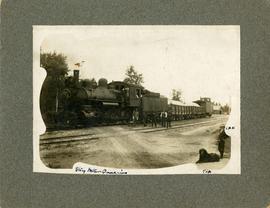
Train at Stony Mountain Quarries
Fait partie de City of Winnipeg Archives Photograph collection
Photograph of men standing in front of a train carrying stone at Stony Mountain Quarries. A man off to the right side is identified as "L.H.K." and the dog next to him is identified as "Tip"[?].
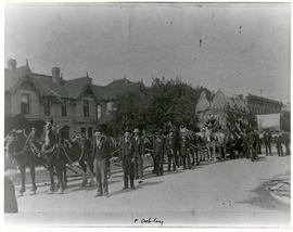
Horses and men leading novelty carriage
Fait partie de City of Winnipeg Archives Photograph collection
Photograph of a cavalcade of horses and men in suits leading a carriage made of hay[?] down an unknown, partially residential street.
Fait partie de City of Winnipeg Archives Photograph collection
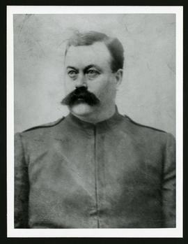
A photograph of William Munro, taken ca. 1900.

Waghorn's Guide map and street index
Fait partie de City Clerk's Library collection
Waghorn's Guide - a small promotional pamphlet published by J.R. Waghorn in 1895. The pamphlet contains a street map of Winnipeg, a street index, and advertisements for various Winnipeg businesses including the Clarendon Hotel, the Redwood Brewery, and the Massey-Harris Company. The map shows the old City of Winnipeg from the Red River on the east to Waverly, Aubrey, and McPhillips Streets on the west, and from Athole Avenue (now Luxton Avenue) in the north to Parker Avenue in the south. Southern Elmwood, Old St. Boniface, and Norwood are also shown on the east side of the river. Railway lines are in black and electric street railway lines are in red.
Procès-verbaux du Conseil (French) - Photocopies
Fait partie de City of St. Boniface
Sans titre

Procès-verbaux du Conseil (French) - Photocopies
Fait partie de City of St. Boniface
Sans titre

Winnipeg General Hospital and Alexandra Park
Fait partie de City of Winnipeg Archives Photograph collection
Postcard shows Winnipeg General Hospital in background, Bannatyne Avenue looking South across Alexandra Park. In foreground, Alexandra Park appears. Shows 1884 and 1897 buildings. Date of postcard is approximate, ca. 1897.
Procès-verbaux du Conseil (French) - Photocopies
Fait partie de City of St. Boniface
Sans titre
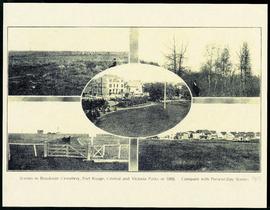
Scenes in Brookside Cemetery, Fort Rouge, Central and Victoria Parks in 1898
Fait partie de Parks and Recreation Photograph collection
A printed page consisting of a 5 photograph collage of scenes from Fort Rouge Park, Central Park, Victoria Park, and Brookside Cemetery. The photographs date from 1898, but the page itself is likely from 1913.
Canadian Postal Card showing Winnipeg City Hall, Main Street and Parliament Buildings
Fait partie de City of Winnipeg Archives Photograph collection
Postcard shows Winnipeg's second city hall (1886-1962), Main Street and Parliament buildings.
Fait partie de City of Winnipeg Archives Photograph collection
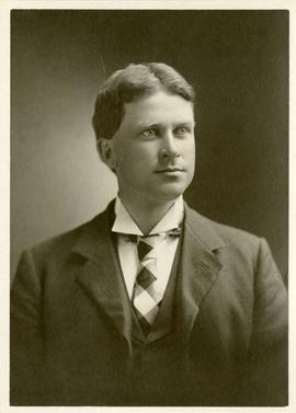
Photograph shows Alfred J. Andrews (1865-1950), Alderman of Winnipeg, 1894-1897, Mayor of Winnipeg, 1898-1899, and a leading member of the Citizens' Committee of One Thousand during the Winnipeg General Strike.
Procès-verbaux du Conseil (French) - Photocopies
Fait partie de City of St. Boniface
Sans titre
Procès-verbaux du Conseil (French) - Photocopies
Fait partie de City of St. Boniface
Sans titre
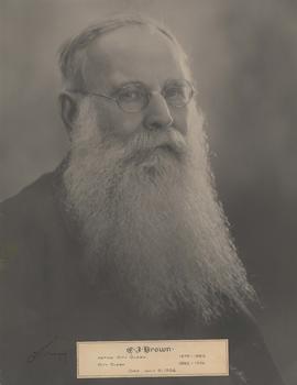
Fait partie de City of Winnipeg Archives Photograph collection
Caption: C. J. Brown. Acting City Clerk 1879-1883. City Clerk 1883-1926. Died July 15, 1926.

Delivery Truck, Lake of the Woods Milling Company
Fait partie de City of Winnipeg Archives Photograph collection
A delivery truck belonging to the Lake of the Woods Milling Company (later known as Five Roses Flour and merged with the Ogilvie Milling Company in 1954), which was based in Keewatin, Ontario.

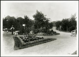
Fait partie de Parks and Recreation Photograph collection
Two young children on a path in Central Park. Photographed by Steele and Company.
Groundskeeper in Fort Rouge Park
Fait partie de Parks and Recreation Photograph collection
A groundskeeper tending to Fort Rouge Park.
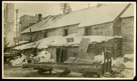
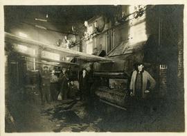
Telfer Block, 156 Lombard Avenue
Fait partie de City of Winnipeg (1874-1971)
Item is part of small album containing photographs of maps tracking the outbreak of typhoid from 1905 to 1908. Item is loose and at back of album. Date of item is approximate, [circa 1905].