

Main Street looking north from Portage Avenue
- i00038
- Item
- 1874
Part of City of Winnipeg (1874-1971)
Bentley Building, Courthouse and Artesian well shown in photograph.
144 results with digital objects Show results with digital objects
Main Street looking north from Portage Avenue
Part of City of Winnipeg (1874-1971)
Bentley Building, Courthouse and Artesian well shown in photograph.
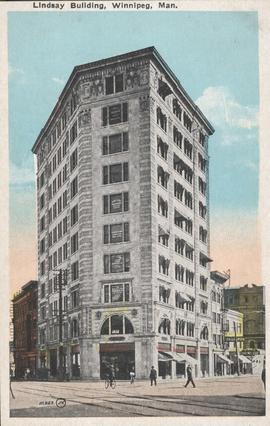
Lindsay Building, Winnipeg, Man.
Item consists of a postcard in printed format that shows the Lindsay Building at 228 Notre Dame Avenue. Published by the Valentine & Sons United Publishing Co. Limited, Toronto and Winnipeg. Printed in U.S.A. Date of postcard is unknown.
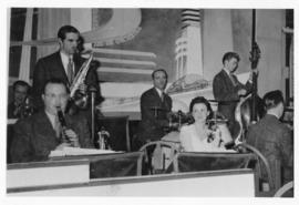
Len Pattendon and His Orchestra at the Roseland, Winnipeg
Part of Owen Clark collection
Date of photograph is approximate, [ca. 1943].
Part of City of Winnipeg (1874-1971)
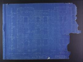
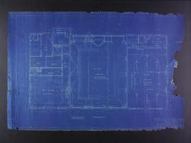
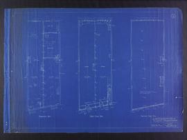
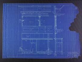
Blueprint plans of Kennedy street elevation of the Medical Arts Building at the corner of Graham Avenue and Kennedy Street. Designed by John D. Atchison. Drawing 4 of 6.
Atchison, John D.
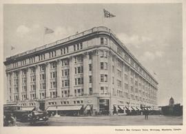
Hudson's Bay Company Store, Winnipeg, Manitoba, Canada
Print is a photographic image of the Hudson's Bay Company Store in Winnipeg.
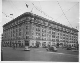
Hudson's Bay Company Store from Portage Avenue at Memorial Boulevard
Date of photograph is approximate, ca. 1942.
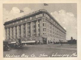
Hudson Bay Co., Store, Winnipeg, Man.
Photograph shows Hudson Bay Company Store at Portage Avenue and Memorial Boulevard. Date of photograph is approximate, ca. 1940.

Grant Plaza Shopping Centre panorama
View of Grant Park Plaza Shopping Centre, 1200-1216 Grant Avenue, 13.2 acres. From left to right: Clarks Discount Store, Dominion Store, Liquor Commission, Clarks Auto Centre. Consists of 3 separate photographs pasted together on cardboard to create a panorama. The cardboard is a scrap made from an old sign of the Metropolitan Corporation of Greater Winnipeg (visible on the reverse). The cardboard is numbered “8”, presumably as part of a compilation with other shopping centre panoramas.
Metropolitan Corporation of Greater Winnipeg (Man.). Planning Division
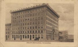
Grain Exchange building, 167 Lombard Avenue, Northeast corner of Rorie Street, ca. 1908
Date of postcard is approximate, ca. 1908.
Fourth floor plans for the Club Building for the Columbus Hall Association
Part of City of Winnipeg (1874-1971)
Blueprint plans of fourth floor of the Club Building for the Columbus Hall Association Ltd. on the southwest corner of Graham Avenue and Smith Street. Designed by John D. Atchison. Drawing 5 of 11.
Atchison, John D.
Footing details for Medical Arts Building at the corner of Graham Avenue and Kennedy Street
Part of City of Winnipeg (1874-1971)
Blueprint plans of footing details of the Medical Arts Building at the corner of Graham Avenue and Kennedy Street. Designed by John D. Atchison. Drawing 6 of 6.
Atchison, John D.
Floor plans for Garage for the McLaughlin Carriage Co., Maryland Street and Portage Avenue
Part of City of Winnipeg (1874-1971)
Blueprint floor plans of a Garage for the McLaughlin Carriage Co., at Maryland Street and Portage Avenue. Designed by J.D. Atchison. Drawing 1 of 2.
Atchison, John D.

Floor plans for business premises of Mr. F.J. Sharpe, Portage Avenue
Part of City of Winnipeg (1874-1971)
Blueprint floor plans of the business premises of Mr. F.J. Sharpe on Portage Avenue. Designed by J.D. Atchison. Drawing 1 of 2. Originally drawn on May 10, 1919, but revised on July 14, 1919.
Atchison, John D.
Floor plans for business premises for Mr. Nation, Portage Avenue
Part of City of Winnipeg (1874-1971)
Blueprint floor plans of the business premises of Mr. Nanton on Portage Avenue. Designed by J.D. Atchison. Drawing 1 of 3.
Atchison, John D.

Page shows five street views of Winnipeg, ca. 1903: 1) Main Street from Commercial Club, 2) Elgin Avenue, 3) Geo. Velie, Wholesale Wines and Liquors, 4) William Avenue, looking west, and 5) Main Street, looking north from Portage Avenue.
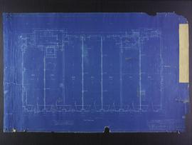
First floor plans for the Club Building for the Columbus Hall Association
Part of City of Winnipeg (1874-1971)
Blueprint plans of first floor of the Club Building for the Columbus Hall Association Ltd. on the southwest corner of Graham Avenue and Smith Street. Designed by John D. Atchison. Drawing 2 of 11.
Atchison, John D.
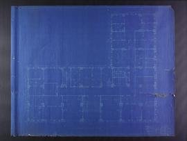
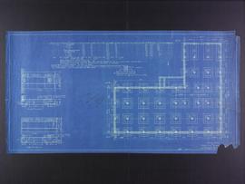
First floor plans for Medical Arts Building at the corner of Graham Avenue and Kennedy Street
Part of City of Winnipeg (1874-1971)
Blueprint plans of first floor of the Medical Arts Building at the corner of Graham Avenue and Kennedy Street. Designed by John D. Atchison. Drawing 2 of 6.
Atchison, John D.
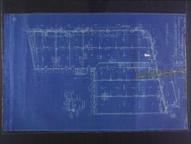
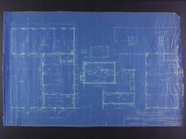
First floor plans for 383-389 Portage Avenue and 290 Edmonton Street (The Edmonton Block)
Part of City of Winnipeg (1874-1971)
Blueprint plans of first floor of 383-389 Portage Avenue and 290 Edmonton Street (the Edmonton Block), designed by John. D. Atchison for W.H. Gardner. Drawing 2 of 6.
Atchison, John D.
Facade plans for business premises for Mr. Nation, Portage Avenue
Part of City of Winnipeg (1874-1971)
Blueprint facade plans of the business premises of Mr. Nanton on Portage Avenue. Designed by J.D. Atchison. Drawing 3 of 3.
Atchison, John D.
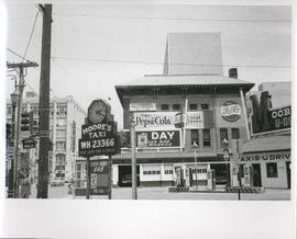
Existing Conditions, Corner of Graham and Donald looking East
A photograph of the southeast corner of Donald Street and Graham Avenue featuring a Moore's Taxi U Drive station in the foreground. Behind it in the background can be seen The Columbus Hall / Aragon Building with advertisements for Pepsi Cola and the Rainbow Dance Gardens, and the Tribune Building can be seen at the left. This is the present site of the Millennium Library. The back of the photo is marked: "Photograph 5. Existing Conditions, corner of Graham and Donald Looking East. Urban Renewal and Rehabilitation Board City of Winnipeg".
Winnipeg (Man.). Urban Renewal and Rehabilitation Board