

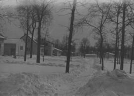
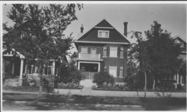
Apartment block at 415 Edison Avenue
- i04658
- Pièce
- [197-?]
Fait partie de City of Winnipeg Archives Photograph collection
Apartment block at 415 Edison Avenue, near Rothesay Street.
Apartment block at 415 Edison Avenue
Fait partie de City of Winnipeg Archives Photograph collection
Apartment block at 415 Edison Avenue, near Rothesay Street.

Aerial of 1974 Flood – Red River between East and West Kildonan
Fait partie de City of Winnipeg Archives Photograph collection
Aerial photograph of the Red River during the 1974 Flood. The photograph faces northwest from around Helmsdale Avenue and Kildonan Drive in East Kildonan towards Scotia Street in the Seven Oaks area of West Kildonan across the river. The photographs were taken by the Department of Environmental Planning.
Sans titre

Aerial of 1974 Flood – Pritchard Avenue Boat Dock and Redwood Bridge
Fait partie de City of Winnipeg Archives Photograph collection
Aerial photograph of the Red River during the 1974 Flood. The photograph faces northwest towards the North End, with the Pritchard Avenue Boat Dock in the bottom left and the Redwood Bridge in the top right. The photographs were taken by the Department of Environmental Planning.
Sans titre

Aerial of 1974 Flood – Fraser’s Grove Park
Fait partie de City of Winnipeg Archives Photograph collection
Aerial photograph of the Red River during the 1974 Flood. The photograph faces southwest from Fraser’s Grove Park and Kildonan Drive in East Kildonan towards Scotia Street in the Seven Oaks area of West Kildonan. The photographs were taken by the Department of Environmental Planning.
Sans titre

Aerial of 1974 Flood – Bergen Cutoff Bridge
Fait partie de City of Winnipeg Archives Photograph collection
Aerial photograph of the Bergen Cutoff Bridge during the 1974 Flood. The photograph faces northwest from Kildonan Drive in North Kildonan across the Red River towards Kildonan Park and Old Kildonan. The photographs were taken by the Department of Environmental Planning.
Sans titre

Aerial of 1974 Flood – Red River between North and West Kildonan
Fait partie de City of Winnipeg Archives Photograph collection
Aerial photograph of the Red River during the 1974 Flood. The photograph faces west from North Kildonan, where the Chief Peguis Trail now stands, across the river towards Kildonan Park and West Kildonan on the left, the North End Water Treatment Plant in the middle, and Old Kildonan on the right. The photographs were taken by the Department of Environmental Planning.
Sans titre

Wildwood Park - Three weeks before flood, 1950
Fait partie de City of Winnipeg Archives Photograph collection

Wildwood Park - Three weeks before flood, 1950
Fait partie de City of Winnipeg Archives Photograph collection
Wildwood Park - Three weeks before flood, 1950
Fait partie de City of Winnipeg Archives Photograph collection

Sandbags on the dyke (Wildwood Park - flood, 1950)
Fait partie de City of Winnipeg Archives Photograph collection
![Sandbags - E sec [section] (Wildwood Park - flood, 1950)](/uploads/r/city-of-winnipeg-archives-amp-records-control-branch/c/4/a/c4a7e5ee657f2cf565da1e983d41beae65af0b67f4b9fb5fa71c540b99003de4/C0013_0000_0000_P0022_0094_001_142.jpg)
Sandbags - E sec [section] (Wildwood Park - flood, 1950)
Fait partie de City of Winnipeg Archives Photograph collection
Fait partie de City of Winnipeg Archives Photograph collection
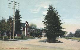
Postcard includes message from Tab to Beat? on verso. Published by C. S. Co. Ltd., Winnipeg, printed in Saxony.
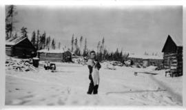
Log cabins at city wood camp, Greater Winnipeg Water District Railway
Fait partie de City of Winnipeg Archives Photograph collection
Photograph shows man standing in front of log cabins used by workers at wood cutting camps. Date of photograph is approximate, ca. 1930.
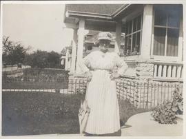
Mother in front of 49 Balmoral Place
Fait partie de City of Winnipeg Archives Photograph collection
Date of photograph is approximate, ca. 1918.
Neta Turner in front of house in Fort Garry, Winnipeg
Fait partie de City of Winnipeg Archives Photograph collection
Date of photograph is approximate, ca. 1918.
Our place - 49 Balmoral Place, Winnipeg, Manitoba
Fait partie de City of Winnipeg Archives Photograph collection
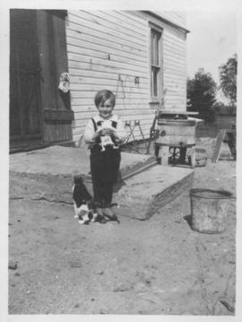
Elva, Manitoba, June 1918, Ken Furtney
Fait partie de City of Winnipeg Archives Photograph collection
Photograph shows child (Ken Furtney) holding kitten, wooden wash tub for laundry in background.

Floods - St. Boniface and Norwood - April 1916
Fait partie de City of Winnipeg Archives Photograph collection
Postcard is a photographic print showing water flooding homes. Photograph taken by Advance Photo Company, Winnipeg. Azo mark appears in stamp box, made in Canada.

Rue Langevin, St. Boniface under water floods April 1916, showing men in boat
Fait partie de City of Winnipeg Archives Photograph collection
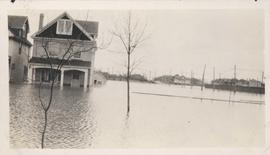
Flood water over front porch of home, 1916 Flood, Norwood
Fait partie de City of Winnipeg Archives Photograph collection
Photograph shows scene from the 1916 flooding of the Assiniboine River in Norwood, flood water levels high enough to submerge front porch of home on left side of photograph.