
Annual Report and Financial Statements - Sinking Fund, 1947
- d00823
- File
- 1947
Greater Winnipeg Water District
177 results with digital objects Show results with digital objects
Annual Report and Financial Statements - Sinking Fund, 1947
Greater Winnipeg Water District
Annual Report and Financial Statements - Sinking Fund, 1948
Greater Winnipeg Water District
Annual Report and Financial Statements - Sinking Fund, 1957
Greater Winnipeg Water District
Annual Report and Financial Statements - Sinking Fund, 1960
Greater Winnipeg Water District
Greater Winnipeg Water District Photos
Consists of photographs taken by GWWD employees during the building of the Greater Winnipeg Aqueduct that brings water from Shoal Lake to Winnipeg.
Greater Winnipeg Water District
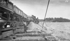
Placing material on Falcon River Diversion Dyke at Indian Bay
Photograph of workers using a scow to place material from cars onto the Falcon River Diversion Dyke at Indian Bay. Photograph taken by William G. Chace, Chief Engineer of the Winnipeg Aqueduct.
Greater Winnipeg Water District

Aqueduct drainage siphon near Meadowvale
Photograph of workers next to a Winnipeg Aqueduct drainage siphon near Meadowvale, Manitoba. Photographer is unknown.
Greater Winnipeg Water District

Aqueduct siphon at Birch River crossing
Photograph of a Winnipeg Aqueduct siphon at the Birch River crossing near McMunn, Manitoba. Photographer is unknown.
Greater Winnipeg Water District
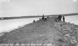
Riprapping west side of Falcon River Diversion Dyke at Indian Bay
Photograph of workers riprapping the west side of the Falcon River Diversion Dyke at Indian Bay. Photographer is unknown.
Greater Winnipeg Water District
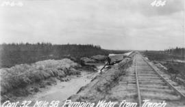
Pumping water from trench near Spruce Siding
Photograph of water being pumped from a trench next to the Greater Winnipeg Water District Railway near Spruce Siding, Manitoba, looking southeast. Photographer is unknown.
Greater Winnipeg Water District
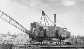
Aqueduct drag line between East Braintree and Shoal Lake
Photograph of a dragline working on the Winnipeg Aqueduct between East Braintree, Manitoba, and Shoal Lake. Photographer is unknown.
Greater Winnipeg Water District

Excavated and timbered Taché surge tower
Photograph of workers excavating the Taché surge tower, which is timbered to the floor. Photographer is unknown.
Greater Winnipeg Water District
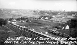
Aqueduct's route through St. Boniface
Photograph of the route of the Winnipeg Aqueduct's 66 inch diameter reinforced concrete pipeline, looking southeast towards where the Canadian Northern Railway line crosses Rue St. Joseph. Photograph taken from a concrete tower near the Taché surge tower by an unknown photographer.
Greater Winnipeg Water District
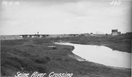
Photograph of the Seine River where the Winnipeg Aqueduct crosses, looking northeast towards the Canadian Northern Railway main line and Rue Notre Dame (at right). Photographer is unknown.
Greater Winnipeg Water District
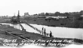
Driving piles into Seine River for aqueduct
Photograph of piles being driven into the Seine River for the Winnipeg Aqueduct, north of Provencher Boulevard. Photographer is unknown.
Greater Winnipeg Water District
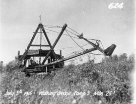
Dredge excavating for aqueduct near Meadowvale
Photograph of a dredge excavating for the Winnipeg Aqueduct near Meadowvale, Manitoba. Photographer is unknown.
Greater Winnipeg Water District
Dredge excavating for aqueduct south of Anola
Photograph of a dredge excavating for the Winnipeg Aqueduct south of Anola, Manitoba. Photographer is unknown.
Greater Winnipeg Water District