
- i03953
- Pièce
- [ca. 1920]
Fait partie de Parks and Recreation Photograph collection
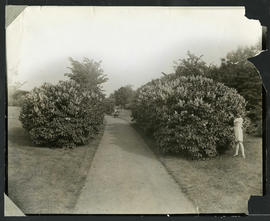
Photograph of a child picking lilacs from a hedge in Elmwood Park. Photograph by Cyril Jessop, 502 Sherburne Street.
15 résultats avec objets numériques Afficher les résultats avec des objets numériques
Fait partie de Parks and Recreation Photograph collection
Photograph of a child picking lilacs from a hedge in Elmwood Park. Photograph by Cyril Jessop, 502 Sherburne Street.
Fait partie de Parks and Recreation Photograph collection
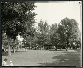
Families enjoying a playground in Elmwood Park.
Fait partie de Parks and Recreation Photograph collection
Photographs of King Edward Park.

View of a pond at King Edward Park
Fait partie de Parks and Recreation Photograph collection
Photograph of a pond in King Edward Park. Photograph by Cyril Jessop.

View of a pond at King Edward Park
Fait partie de Parks and Recreation Photograph collection
Photograph of a pond in King Edward Park. Photograph by Cyril Jessop.

View of a pond at King Edward Park
Fait partie de Parks and Recreation Photograph collection
Photograph of a pond surrounded by people in King Edward Park.
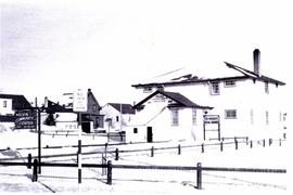
Exterior of Kelvin Community Centre
Fait partie de Parks and Recreation Photograph collection
Photograph of the exterior of the Kelvin Community Centre.
Fait partie de Parks and Recreation Photograph collection
Photographs of the Kelvin Community Centre in Elmwood and a game of lacrosse played by the Elmwood Pats. These photographs were used for the book “A City at Leisure” by Catherine Macdonald.
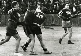
Elmwood Pats competing in lacrosse game
Fait partie de Parks and Recreation Photograph collection
Action shot of the Elmwood Pats playing lacrosse, likely at the Kelvin Community Centre.
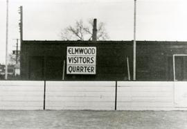
Original boxcar clubhouse at Kelvin Community Centre
Fait partie de Parks and Recreation Photograph collection
The original boxcar clubhouse at the Kelvin Community Centre with a sign reading “Elmwood Visitors Quarter”.

Waghorn's Guide map and street index
Fait partie de City Clerk's Library collection
Waghorn's Guide - a small promotional pamphlet published by J.R. Waghorn in 1895. The pamphlet contains a street map of Winnipeg, a street index, and advertisements for various Winnipeg businesses including the Clarendon Hotel, the Redwood Brewery, and the Massey-Harris Company. The map shows the old City of Winnipeg from the Red River on the east to Waverly, Aubrey, and McPhillips Streets on the west, and from Athole Avenue (now Luxton Avenue) in the north to Parker Avenue in the south. Southern Elmwood, Old St. Boniface, and Norwood are also shown on the east side of the river. Railway lines are in black and electric street railway lines are in red.
![East Kildonan [Aerial view]](/uploads/r/city-of-winnipeg-archives-amp-records-control-branch/8/6/0/860fdea3b1f6bcb68bd68a791365ae9deb8f9cd14834a8814d48663ae6ce80b6/C0013_0000_0000_P0018_0031_001_142.jpg)
Fait partie de City of Winnipeg Archives Photograph collection
Inscription (on recto): WG A155, East Kildonan - 1944.
![Vicinity of Elmwood Park [Aerial view]](/uploads/r/city-of-winnipeg-archives-amp-records-control-branch/5/b/9/5b929d618c2f619e557788462eee14587693511e7959bc6ca77ae96654d1bc98/C0013_0000_0000_P0018_0041_001_142.jpg)
Vicinity of Elmwood Park [Aerial view]
Fait partie de City of Winnipeg Archives Photograph collection
Inscription (on recto): WG M35: 3-15, 5 Mar '45, vicinity Elmwood Park Wpg, appr. scale 1/12000.
![Vicinity of Elmwood Park [Aerial view]](/uploads/r/city-of-winnipeg-archives-amp-records-control-branch/c/6/d/c6dc0bd0b8c2199f232fe8c7f5245d25e681a6a759be00e013a35a7a1ecada23/C0013_0000_0000_P0018_0042_001_142.jpg)
Vicinity of Elmwood Park [Aerial view]
Fait partie de City of Winnipeg Archives Photograph collection
Inscription (on recto): WG M35: 3-16, 5 Mar '45, vicinity Elmwood Park Wpg, appr scale 1/12000.

Aerial view of Point Douglas, St. Boniface, and Elmwood areas
Fait partie de City of Winnipeg Archives Photograph collection
Aerial photograph of Point Douglas, St. Boniface, and west Elmwood.

Fait partie de City of Winnipeg Archives Photograph collection
An aerial view of East Kildonan between the roughly between the Red River and Watt Street, including Henderson Highway.
Fait partie de City of Winnipeg (1874-1971)
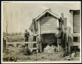
Item is part of small album containing photographs of maps tracking the outbreak of typhoid from 1905 to 1908 and other scenes. Item is loose and at back of album. Date of item is approximate, [circa 1909].
Scrapbook [1950 flood photographs]
Fait partie de City of Winnipeg (1874-1971)
Subseries consists of a scrapbook assembled by the City Engineering Department to serve as photographic evidence of the 1950 flood. It contains black and white photographs that mostly document flooding in residential areas near the Red River (Fort Rouge, Riverview, North End, Point Douglas, Crescentwood, Armstrong's Point and others). Scrapbook appears to be organized geographically by area and street. In addition to documenting flooding, the photographs provide a detailed record of residential neighbourhoods, houses, streets, and businesses like corner grocery stores and laundries. All photographs were taken by Harold K. White Studio.
Sans titre
Fait partie de City of Winnipeg (1874-1971)
A photograph taken during the 1950 flood, showing 336 Glenwood Crescent. Item is 1 of 7 photographs on page 77 of scrapbook.
Sans titre
Fait partie de City of Winnipeg (1874-1971)
A photograph taken during the 1950 flood, showing 320 Glenwood Crescent. Item is 2 of 7 photographs on page 77 of scrapbook.
Sans titre