Aerial photograph of the Red River during the 1974 Flood. The photograph faces northwest towards the North End, with the Pritchard Avenue Boat Dock in the bottom left and the Redwood Bridge in the top right. The photographs were taken by the Department of Environmental Planning.
Winnipeg (Man.). Department of Environmental Planning
Aerial photograph of the Red River during the 1974 Flood. The photograph faces southwest from Fraser’s Grove Park and Kildonan Drive in East Kildonan towards Scotia Street in the Seven Oaks area of West Kildonan. The photographs were taken by the Department of Environmental Planning.
Winnipeg (Man.). Department of Environmental Planning
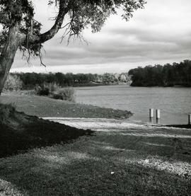
Photograph of the first public boat ramp in Winnipeg, built in 1967 and located in Crescent Drive Park. Photo's reverse is stamped by the Parks and Protection Division of the Metro Government.
Metropolitan Corporation of Greater Winnipeg (Man.). Information Officer
Photograph of a footbridge across the La Salle River in La Barriere Park. A description of the photo used for publication is recorded on a separate piece of paper. Photo's reverse is stamped by the Parks and Protection Division of the Metro Government.
Metropolitan Corporation of Greater Winnipeg (Man.). Information Officer