
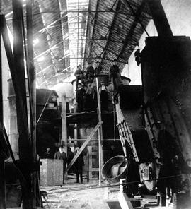
James Avenue Pumping Station – interior
- i04032
- Pièce
- [1907?]
Fait partie de City of Winnipeg Archives Photograph collection
Interior shot of the James Avenue Pumping Station on James Avenue and Amy Street, still under construction.
3968 résultats avec objets numériques Afficher les résultats avec des objets numériques
James Avenue Pumping Station – interior
Fait partie de City of Winnipeg Archives Photograph collection
Interior shot of the James Avenue Pumping Station on James Avenue and Amy Street, still under construction.
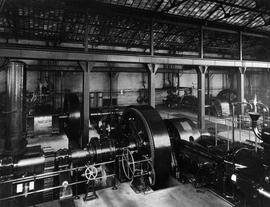
James Avenue Pumping Station – interior
Fait partie de City of Winnipeg Archives Photograph collection
Interior shot of the James Avenue Pumping Station on James Avenue and Amy Street.
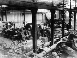
James Avenue Pumping Station – interior
Fait partie de City of Winnipeg Archives Photograph collection
Interior shot of the James Avenue Pumping Station on James Avenue and Amy Street, still under construction.

Winnipeg Tourist Cabins and Camp Park on Pembina Highway
Fait partie de City of Winnipeg Archives Photograph collection
Postcard featuring “Winnipeg Tourist Cabins and Camp Park”, located on Pembina Highway (then Highway Number 14) around Chevrier Boulevard.

Winnipeg’s Best Tourist Cabin Camp on Pembina Highway
Fait partie de City of Winnipeg Archives Photograph collection
Postcard featuring “Winnipeg’s Best Tourist Cabin Camp”, located on Pembina Highway (then Highway Number 14) around Chevrier Boulevard.
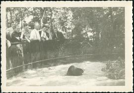
Original beaver enclosure at Assiniboine Park
Fait partie de City of Winnipeg Archives Photograph collection
Audience admiring a beaver in Assiniboine Park’s first beaver enclosure.

Aerial of 1974 Flood – Fraser’s Grove Park
Fait partie de City of Winnipeg Archives Photograph collection
Aerial photograph of the Red River during the 1974 Flood. The photograph faces southwest from Fraser’s Grove Park and Kildonan Drive in East Kildonan towards Scotia Street in the Seven Oaks area of West Kildonan. The photographs were taken by the Department of Environmental Planning.
Sans titre

Aerial of 1974 Flood – Pritchard Avenue Boat Dock and Redwood Bridge
Fait partie de City of Winnipeg Archives Photograph collection
Aerial photograph of the Red River during the 1974 Flood. The photograph faces northwest towards the North End, with the Pritchard Avenue Boat Dock in the bottom left and the Redwood Bridge in the top right. The photographs were taken by the Department of Environmental Planning.
Sans titre

Aerial of 1974 Flood – Bergen Cutoff Bridge
Fait partie de City of Winnipeg Archives Photograph collection
Aerial photograph of the Bergen Cutoff Bridge during the 1974 Flood. The photograph faces northwest from Kildonan Drive in North Kildonan across the Red River towards Kildonan Park and Old Kildonan. The photographs were taken by the Department of Environmental Planning.
Sans titre

Aerial of 1974 Flood – Red River between North and West Kildonan
Fait partie de City of Winnipeg Archives Photograph collection
Aerial photograph of the Red River during the 1974 Flood. The photograph faces west from North Kildonan, where the Chief Peguis Trail now stands, across the river towards Kildonan Park and West Kildonan on the left, the North End Water Treatment Plant in the middle, and Old Kildonan on the right. The photographs were taken by the Department of Environmental Planning.
Sans titre

Aerial of 1974 Flood – Red River between East and West Kildonan
Fait partie de City of Winnipeg Archives Photograph collection
Aerial photograph of the Red River during the 1974 Flood. The photograph faces northwest from around Helmsdale Avenue and Kildonan Drive in East Kildonan towards Scotia Street in the Seven Oaks area of West Kildonan across the river. The photographs were taken by the Department of Environmental Planning.
Sans titre
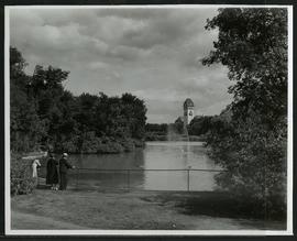
Duck pond and pavilion at Assiniboine Park
Fait partie de City of Winnipeg Archives Photograph collection
A family enjoying the duck pond and the view of the pavilion at Assiniboine Park.

Thoroughfares: Academy Road at Wellington Crescent
Fait partie de City of Winnipeg Archives Photograph collection
View of cars and cyclists heading down Academy Road towards Wellington Crescent and the Maryland Bridge. A small portion of Misericordia Hospital can be seen across the bridge.

Thoroughfares: Academy Road at Wellington Crescent
Fait partie de City of Winnipeg Archives Photograph collection
View of cars and cyclists heading down Academy Road towards Wellington Crescent and the Maryland Bridge. The cupola of Misericordia Hospital can be seen across the bridge.
Arthur and Fred Landen photograph album
Fait partie de City of Winnipeg Archives Photograph collection
Photograph album created by brothers Arthur and Fred Landen of Hull, England. Consists of circa 150 photographs of Arthur Landen’s time as Honourable Lieutenant and Quartermaster in the 1st Battalion of the Northumberland Fusiliers while stationed in Spain, Gibraltar, Egypt, and elsewhere in Africa between 1887 and 1907, as well as circa 40 photographs of Fred Landen’s stay in Winnipeg between 1903 and 1906 and his home in Hull, England. Winnipeg photographs feature homes, commercial buildings, and modes of transporation. The pages are loose and many of the photographs are faded.
Sans titre

Aerial view of Riverview, St. Vital, and Wildwood
Fait partie de City of Winnipeg Archives Photograph collection
Aerial view of the Riverview area of Fort Rouge, including Osborne Street; the Wildwood area of Fort Garry; and the Kingston Crescent, Elm Park, Varennes, St. George, and Glenlawn areas of St. Vital, including Kingston Row, St. Mary’s Road, and St. Anne’s Road.

Polo Park Shopping Centre panorama
Fait partie de City of Winnipeg Archives Photograph collection
View of Polo Park Shopping Centre, 1485 Portage Avenue, 41 acres. East side of shopping centre. From left to right: the Pancake House, Simpsons-Sears, Perth's Dry Cleaners, Genser's Furniture, Daytons, Jack and Jill, Reward, Gordi's Restaurant, Ricki’s, addition to shopping centre under construction, Dominion Store, CJAY-TV Station (CKY-TV), Winnipeg Arena. Consists of 4 separate photographs pasted together on cardboard to create a panorama. The cardboard is a scrap made from an old sign of the Metropolitan Corporation of Greater Winnipeg (visible on the reverse). The cardboard is numbered “12”, presumably as part of a compilation with other shopping centre panoramas.
Sans titre

Polo Park Shopping Centre panorama
Fait partie de City of Winnipeg Archives Photograph collection
View of Polo Park Shopping Centre, 1485 Portage Avenue, 41 acres. West side of shopping centre, north side of Portage Avenue between Empress Street and St. James Street. Left to Right: Winnipeg Stadium, Winnipeg Arena, Loblaws, Simpson Sears Marina, Simpson Sears Garden Shop, Simpson Sears Department Store, Simpson Sears Service Station. Consists of 4 separate photographs pasted together on cardboard to create a panorama. The cardboard is a scrap made from an old sign of the Metropolitan Corporation of Greater Winnipeg (visible on the reverse). The cardboard is numbered “11”, presumably as part of a compilation with other shopping centre panoramas.
Sans titre

Northgate Shopping Centre panorama
Fait partie de City of Winnipeg Archives Photograph collection
View of Northgate Plaza Shopping Centre, 1375-1425 McPhillips Street, 15 acres. From left to right: Clarks Discount Store, Various Shops, Northgate Bowling Lanes, Loblaw's. Consists of 3 separate photographs pasted together on cardboard to create a panorama. The cardboard is a scrap made from an old sign of the Metropolitan Corporation of Greater Winnipeg (visible on the reverse). The cardboard is numbered “14”, presumably as part of a compilation with other shopping centre panoramas.
Sans titre

Polo Park Shopping Centre panorama
Fait partie de City of Winnipeg Archives Photograph collection
View of Polo Park Shopping Centre, 1485 Portage Avenue, 41 acres. South side of shopping centre. Left to right: Winnipeg Motor Products, Motor Club, Simpson Sears Service Station, Simpson Sears Department Store. Consists of 3 separate photographs pasted together on cardboard to create a panorama. The cardboard is a scrap made from an old sign of the Metropolitan Corporation of Greater Winnipeg (visible on the reverse). The cardboard is numbered “13”, presumably as part of a compilation with other shopping centre panoramas.
Sans titre