
- i00149
- Item
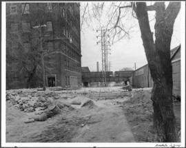
- 1950
Part of City of Winnipeg (1874-1971)
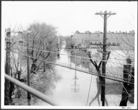
A photograph of hydro wires along flooded Bell Avenue during the 1950 flood in Winnipeg.
Harold K. White Studio
355 results with digital objects Show results with digital objects
Part of City of Winnipeg (1874-1971)
A photograph of hydro wires along flooded Bell Avenue during the 1950 flood in Winnipeg.
Harold K. White Studio

Beginning of Causeway Sutherland at Disraeli
Part of City of Winnipeg (1874-1971)
A photograph of equipment and vehicles at the beginning of a rock causeway at the intersection of Sutherland Avenue and Disraeli Street during the 1950 flood.
Harold K. White Studio
Part of City of Winnipeg (1874-1971)
A photograph taken during the 1950 flood, showing Maplewood Avenue and Bartlett Avenue. Item is 7 of 7 photographs on page 21 of scrapbook.
Harold K. White Studio

Bannerman and St. Cross looking east
Part of City of Winnipeg (1874-1971)
A photograph, looking east, of flooding at the intersection of Bannerman Avenue and St. Cross Street during the 1950 flood in Winnipeg.
Harold K. White Studio
Part of City of Winnipeg (1874-1971)
A photograph taken during the 1950 flood, showing Badminton Court. Item is 4 of 8 photographs on page 87 of scrapbook.
Harold K. White Studio
Back of Brown and Rutherford (Buchanan Street)
Part of City of Winnipeg (1874-1971)
A photograph taken during the 1950 flood, showing Back of Brown and Rutherford (Buchanan Street). Item is 6 of 6 photographs on page 73 of scrapbook.
Harold K. White Studio
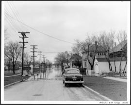
Part of City of Winnipeg (1874-1971)
A photograph, looking north, of flooding at the intersection of Atlantic Avenue and St. Cross Street during the flood of 1950 in Winnipeg.
Harold K. White Studio
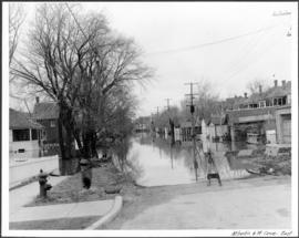
Part of City of Winnipeg (1874-1971)
A photograph, looking east, of flooding at the intersection of Atlantic Avenue and St. Cross Street during the 1950 flood in Winnipeg.
Harold K. White Studio

Photograph is one of five photos mounted on page with caption "Assiniboine River flooded, Spring 1916."

Part of City of Winnipeg (1874-1971)
A photograph of flooded Assiniboine Avenue during the 1950 flood in Winnipeg.
Harold K. White Studio

Part of City of Winnipeg (1874-1971)
A photograph, taken from the north, of a flooded underpass on Anabella Street during the 1950 flood in Winnipeg. Some people in a boat are travelling down the street.
Harold K. White Studio
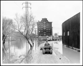
Part of City of Winnipeg (1874-1971)
A photograph of a causeway near an underpass on Anabella Street during the 1950 flood in Winnipeg. A city employee is driving some equipment down the causeway.
Harold K. White Studio
Part of City of Winnipeg (1874-1971)
A photograph of a flooded underpass on Anabella Street during the 1950 flood in Winnipeg.
Harold K. White Studio

Aerial of 1974 Flood – Red River between North and West Kildonan
Aerial photograph of the Red River during the 1974 Flood. The photograph faces west from North Kildonan, where the Chief Peguis Trail now stands, across the river towards Kildonan Park and West Kildonan on the left, the North End Water Treatment Plant in the middle, and Old Kildonan on the right. The photographs were taken by the Department of Environmental Planning.
Winnipeg (Man.). Department of Environmental Planning

Aerial of 1974 Flood – Red River between East and West Kildonan
Aerial photograph of the Red River during the 1974 Flood. The photograph faces northwest from around Helmsdale Avenue and Kildonan Drive in East Kildonan towards Scotia Street in the Seven Oaks area of West Kildonan across the river. The photographs were taken by the Department of Environmental Planning.
Winnipeg (Man.). Department of Environmental Planning

Aerial of 1974 Flood – Pritchard Avenue Boat Dock and Redwood Bridge
Aerial photograph of the Red River during the 1974 Flood. The photograph faces northwest towards the North End, with the Pritchard Avenue Boat Dock in the bottom left and the Redwood Bridge in the top right. The photographs were taken by the Department of Environmental Planning.
Winnipeg (Man.). Department of Environmental Planning

Aerial of 1974 Flood – Fraser’s Grove Park
Aerial photograph of the Red River during the 1974 Flood. The photograph faces southwest from Fraser’s Grove Park and Kildonan Drive in East Kildonan towards Scotia Street in the Seven Oaks area of West Kildonan. The photographs were taken by the Department of Environmental Planning.
Winnipeg (Man.). Department of Environmental Planning

Aerial of 1974 Flood – Bergen Cutoff Bridge
Aerial photograph of the Bergen Cutoff Bridge during the 1974 Flood. The photograph faces northwest from Kildonan Drive in North Kildonan across the Red River towards Kildonan Park and Old Kildonan. The photographs were taken by the Department of Environmental Planning.
Winnipeg (Man.). Department of Environmental Planning
Part of City of Winnipeg (1874-1971)
A photograph taken during the 1950 flood, showing 99 Matheson Avenue and 103 Matheson Avenue. Item is 5 of 6 photographs on page 42 of scrapbook.
Harold K. White Studio
Part of City of Winnipeg (1874-1971)
A photograph taken during the 1950 flood, showing 96 Eastgate. Item is 1 of 2 photographs on page 96 of scrapbook.
Harold K. White Studio