

Aerial view of Point Douglas, St. Boniface, and Elmwood areas
- i03883
- Item
- [1940s?]
Aerial photograph of Point Douglas, St. Boniface, and west Elmwood.
70 results with digital objects Show results with digital objects
Aerial view of Point Douglas, St. Boniface, and Elmwood areas
Aerial photograph of Point Douglas, St. Boniface, and west Elmwood.
![CNR Yards [Aerial view]](/uploads/r/city-of-winnipeg-archives-amp-records-control-branch/e/1/8/e184dce7e98d8a8fabf3b8481cfbdc63ba39898edb5f89746bd2e0a6795f8148/C0013_0000_0000_P0018_0045_001_142.jpg)

No. 8 A portion of the Lyndale dike in Norwood with the Norwood Bridge in the background
Photograph shows scene from 1950 flood. Description (on verso): Note the roof of the Greater Winnipeg Sanitary District Marion Street pumping station on the right. Stamp (on verso): City of Winnipeg - Engineering Dept., Water Works Division, Ross and Tecumseh.

1950 Flood - Flood Evacuees at the St. Boniface train station
A Short, Pictorial Documentary on the Winnipeg Flood of 1950
Portigal & Wardle

La Verendrye Band in front of the St. Boniface Cathedral
Part of Owen Clark collection
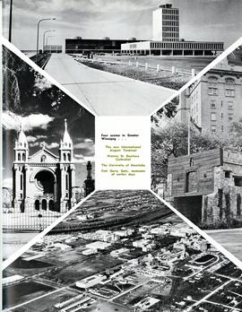
Four scenes in Greater Winnipeg
Photograph shows the then new International Airport Terminal, the St. Boniface Cathedral prior to the 1968 fire, the University of Manitoba and the Fort Garry Gate.
Metropolitan Corporation of Greater Winnipeg (Man.)

Southdale Shopping Centre panorama
View of Southdale Shopping Centre, 35 Lakewood Boulevard, 12.8 acres. From left to right: Dominion Store, Canadian Imperial Bank of Commerce, Mall Entrance, Quintons, Ebbeling Pharmacy, Kmart Department Store. Consists of 3 separate photographs pasted together on cardboard to create a panorama. The cardboard is a scrap made from an old sign of the Metropolitan Corporation of Greater Winnipeg (visible on the reverse). The cardboard is numbered “5”, presumably as part of a compilation with other shopping centre panoramas.
Metropolitan Corporation of Greater Winnipeg (Man.). Planning Division
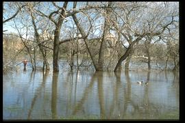
1997 flood - The Forks - view of St. Boniface across river
Part of Winnipeg Flood Record and Archives Committee collection
A photograph of St. Boniface Cathedral, taken from across the flooded Red River during the 1997 flood.
Winnipeg (Man.). Community Services Department
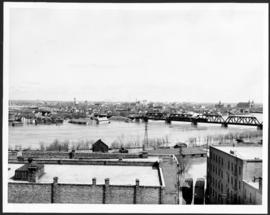
Flooding on the Red River towards St. Boniface.
Part of City of Winnipeg (1874-1971)
A photograph of the flooded Red River during the 1950 flood in Winnipeg. The photograph is taken looking toward St. Boniface.
Harold K. White Studio

Building Water Street causeway about 2nd day
Part of City of Winnipeg (1874-1971)
A photograph of the building of the Water Street causeway during the 1950 flood in Winnipeg. St. Boniface Cathedral can be seen in the background.
Harold K. White Studio