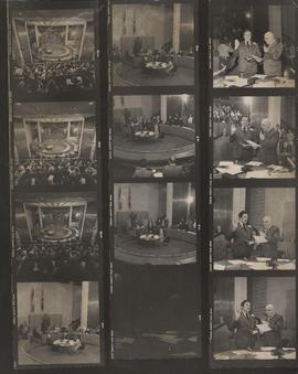
Item consists of a contact sheet with twelve different images showing the Inaugural Meeting of City Council and Declaration of Office, November 1, 1977. Mayor Robert Steen and City Clerk Herb E. Sanger in view. Photographer's stamp on verso.
Photograph shows first session of Council after it was reduced from 50 Councillors to 29 Councillors, taken from seating gallery looking down into Council Chamber. - Stamp (on verso): Photograph by Hugh Allan, 116 Hazeldell Ave, Winnipeg, Man., R2F 0P5.
Caption: H. E. Sanger. Entered Service of the City July 1st, 1938. Deputy City Clerk March 13th, 1966. City Clerk, 1976-1979. Retired September 19th, 1979.
Consists of a PDF compiling scanned photographs and other information related to Pearl Franz (née Debooy), a member of an all girls cycling club at St. Mary’s Academy in the 1970s. Donation courtesy of Pearl Franz.
Aerial photograph of the Red River during the 1974 Flood. The photograph faces northwest from around Helmsdale Avenue and Kildonan Drive in East Kildonan towards Scotia Street in the Seven Oaks area of West Kildonan across the river. The photographs were taken by the Department of Environmental Planning.
Aerial photograph of the Red River during the 1974 Flood. The photograph faces northwest towards the North End, with the Pritchard Avenue Boat Dock in the bottom left and the Redwood Bridge in the top right. The photographs were taken by the Department of Environmental Planning.
Aerial photograph of the Red River during the 1974 Flood. The photograph faces southwest from Fraser’s Grove Park and Kildonan Drive in East Kildonan towards Scotia Street in the Seven Oaks area of West Kildonan. The photographs were taken by the Department of Environmental Planning.
Aerial photograph of the Bergen Cutoff Bridge during the 1974 Flood. The photograph faces northwest from Kildonan Drive in North Kildonan across the Red River towards Kildonan Park and Old Kildonan. The photographs were taken by the Department of Environmental Planning.
Aerial photograph of the Red River during the 1974 Flood. The photograph faces west from North Kildonan, where the Chief Peguis Trail now stands, across the river towards Kildonan Park and West Kildonan on the left, the North End Water Treatment Plant in the middle, and Old Kildonan on the right. The photographs were taken by the Department of Environmental Planning.