

Crane and David, Bakers and Confectioners
- i01411
- Item
- [ca. 1910]
Staff standing in front of Crane and David Bakers and Confectioners at 765 Dufferin Avenue and a horse-drawn delivery cart.
Crane and David, Bakers and Confectioners
Staff standing in front of Crane and David Bakers and Confectioners at 765 Dufferin Avenue and a horse-drawn delivery cart.

View of Main Street south from Higgins showing Alberta Hotel
Date of photograph is uncertain, [before 1949].

Overhanging Signs: North side of Portage Avenue looking West from Young Street
Photograph shows signs for multiple businesses, including Club Morocco, Riviera Restaurant, Princeton Café Fish and Chips, Portage Credit Jewellers. Date of photograph is uncertain, [196-?].
Date of photograph is uncertain, [before 1949].
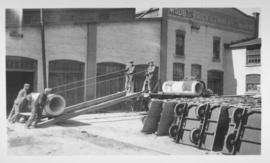
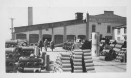
Men loading concrete forms onto truck
One of the men shown in photograph identified as Frank Richards. Wood's Brick Company Ltd. building visible in background. Date of photograph is uncertain, [before 1949].
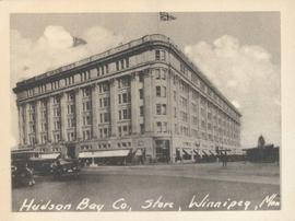
Hudson Bay Co., Store, Winnipeg, Man.
Photograph shows Hudson Bay Company Store at Portage Avenue and Memorial Boulevard. Date of photograph is approximate, ca. 1940.
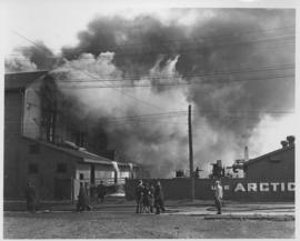
Arctic Ice Company's Bell Avenue yards fire, September 5, 1948
Stamp (on verso): Anderson-Brunnen Photographers, 410 Boyd Bldg. - Phone 93 900.
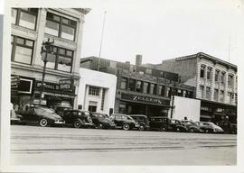
Storefronts on Portage Avenue between Carlton and Hargrave Streets
Cars and shoppers in front of stores on the north side of Portage Avenue, between Carlton and Hargrave Streets. Featured are The Berryhill Shoe Store in the Enderton / Mitchell-Copp Building, the Bank of Montreal, Zeller's (Zellers), and Rannards Shoes in

Portage Avenue looking west from Colony Street
A view of Portage Avenue looking west from Colony Street. The Hudson's Bay Company Building is featured prominantly and the Power Building and the Boyd Building are visible farther west.

Dakota Village Shopping Centre panorama
View of Dakota Village Shopping Centre, 1077-1095 St. Mary's Road, 3.5 acres. From left to right: unknown stores, Ladies and Children's Wear, Lance Pharmacy, [Dakota?] Bowling, Shoe Fair, Bank of Nova Scotia, Safeway, apartment block, Bank of Montreal. Consists of 3 separate photographs pasted together on cardboard to create a panorama. The cardboard is a scrap made from an old sign of the Metropolitan Corporation of Greater Winnipeg (visible on the reverse). The cardboard is numbered “6”, presumably as part of a compilation with other shopping centre panoramas.
Metropolitan Corporation of Greater Winnipeg (Man.). Planning Division
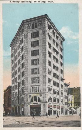
Lindsay Building, Winnipeg, Man.
Item consists of a postcard in printed format that shows the Lindsay Building at 228 Notre Dame Avenue. Published by the Valentine & Sons United Publishing Co. Limited, Toronto and Winnipeg. Printed in U.S.A. Date of postcard is unknown.
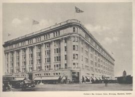
Hudson's Bay Company Store, Winnipeg, Manitoba, Canada
Print is a photographic image of the Hudson's Bay Company Store in Winnipeg.
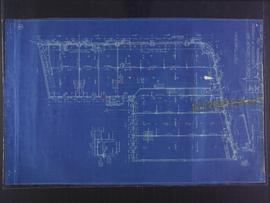
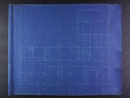
First floor plans for 383-389 Portage Avenue and 290 Edmonton Street (The Edmonton Block)
Part of City of Winnipeg (1874-1971)
Blueprint plans of first floor of 383-389 Portage Avenue and 290 Edmonton Street (the Edmonton Block), designed by John. D. Atchison for W.H. Gardner. Drawing 2 of 6.
Atchison, John D.

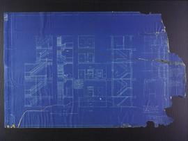
Second floor plans for 383-389 Portage Avenue and 290 Edmonton Street (The Edmonton Block)
Part of City of Winnipeg (1874-1971)
Blueprint plans of second floor of 383-389 Portage Avenue and 290 Edmonton Street (the Edmonton Block), designed by John. D. Atchison for W.H. Gardner. Drawing 3 of 6.
Atchison, John D.

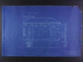
Elevation plans for 383-389 Portage Avenue and 290 Edmonton Street (The Edmonton Block)
Part of City of Winnipeg (1874-1971)
Blueprint plans of elevation of 383-389 Portage Avenue and 290 Edmonton Street (the Edmonton Block), designed by John. D. Atchison for W.H. Gardner. Drawing 5 of 6.
Atchison, John D.
Elevation plans for 383-389 Portage Avenue and 290 Edmonton Street (The Edmonton Block)
Part of City of Winnipeg (1874-1971)
Blueprint plans of elevation of 383-389 Portage Avenue and 290 Edmonton Street (the Edmonton Block), designed by John. D. Atchison for W.H. Gardner. Drawing 6 of 6.
Atchison, John D.
Third floor plans for the Club Building for the Columbus Hall Association
Part of City of Winnipeg (1874-1971)
Blueprint plans of third floor of the Club Building for the Columbus Hall Association Ltd. on the southwest corner of Graham Avenue and Smith Street. Designed by John D. Atchison. Drawing 4 of 11.
Atchison, John D.
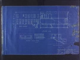
East elevation plans for the Club Building for the Columbus Hall Association
Part of City of Winnipeg (1874-1971)
Blueprint plans of east elevation of the Club Building for the Columbus Hall Association Ltd. on the southwest corner of Graham Avenue and Smith Street. Designed by John D. Atchison. Drawing 6 of 11.
Atchison, John D.
Stair and elevator plans for the Club Building for the Columbus Hall Association
Part of City of Winnipeg (1874-1971)
Blueprint plans of stairs and elevators of the Club Building for the Columbus Hall Association Ltd. on the southwest corner of Graham Avenue and Smith Street. Designed by John D. Atchison. Drawing 11 of 11.
Atchison, John D.
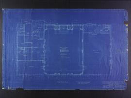
Basement plans for Medical Arts Building at the corner of Graham Avenue and Kennedy Street
Part of City of Winnipeg (1874-1971)
Blueprint plans of basement of the Medical Arts Building at the corner of Graham Avenue and Kennedy Street. Designed by John D. Atchison. Drawing 1 of 6.
Atchison, John D.