
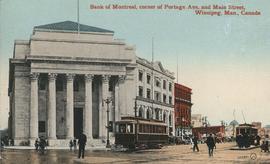
Bank of Montreal, corner of Portage Avenue and Main Street
- i01671
- Pièce
- 1912
Fait partie de City of Winnipeg Archives Photograph collection
Date of postcard is approximate, ca. 1912.
Bank of Montreal, corner of Portage Avenue and Main Street
Fait partie de City of Winnipeg Archives Photograph collection
Date of postcard is approximate, ca. 1912.
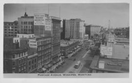
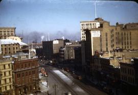
Portage Avenue, Winnipeg, Manitoba
Fait partie de City of Winnipeg Archives Photograph collection
Photograph shows view of Paris and Avenue buildings and Bank of Nova Scotia building. Date of photograph is approximate, ca. 1940.
![Logan Avenue and Salter Street [Aerial view]](/uploads/r/city-of-winnipeg-archives-amp-records-control-branch/9/8/0/980f8ba4214d821c9b49366ae35d9ea9ed5b7f44366c5cd894e04befdd6c7a22/C0013_0000_0000_P0018_0033_001_142.jpg)
Logan Avenue and Salter Street [Aerial view]
Fait partie de City of Winnipeg Archives Photograph collection
Inscription (on recto): A161 3-9-43 Logan Ave and Salter St Wp [Winnipeg?] about 4000' 5".
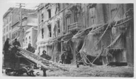
The "Blue Store," Main Street, Winnipeg after fire - January 25, 1918
Fait partie de City of Winnipeg Archives Photograph collection

Fait partie de City of Winnipeg Archives Photograph collection
Photograph is one of five photos mounted on page with caption "Assiniboine River flooded, Spring 1916."
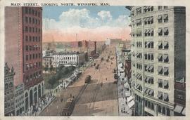
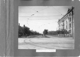
Main Street, looking north, Winnipeg, Man.
Fait partie de City of Winnipeg Archives Photograph collection
Postcard showing Main Street looking north from Bannatyne Avenue. Date of postcard is unknown.

Corner Portage Avenue and Main Street, Winnipeg, Manitoba
Fait partie de City of Winnipeg Archives Photograph collection
Print is a photographic image of the intersection of Portage Avenue and Main Street. Date of print is uncertain, [193-].
Fait partie de City of Winnipeg Archives Photograph collection
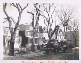
City crews trimming tree branches
Fait partie de City of Winnipeg Archives Photograph collection
Photograph shows city crews trimming tree branches.

The Cove Restaurant, corner of Portage and Carlton
Fait partie de City of Winnipeg Archives Photograph collection
Photograph of "The Cove" Restaurant at 355 Portage Avenue, at Carlton Street. The photograph was taken from a building on Carlton Street looking southeast towards the Eaton's Building, Mitchell-Copp, Zeller's, and the Carlton Building.

Main Street looking northeast to Grace Methodist Church
Fait partie de City of Winnipeg Archives Photograph collection
Photograph of a muddy Main Street in 1871, facing northeast from around St. Mary Avenue. Featured on the photograph's right-hand side is Grace Methodist Church, located at Main Street and Water Avenue (now William Stephenson Way), which was opened on September 17 of that year.

Thoroughfares: Academy Road at Wellington Crescent
Fait partie de City of Winnipeg Archives Photograph collection
View of cars and cyclists heading down Academy Road towards Wellington Crescent and the Maryland Bridge. A small portion of Misericordia Hospital can be seen across the bridge.

Waghorn's Guide map and street index
Fait partie de City Clerk's Library collection
Waghorn's Guide - a small promotional pamphlet published by J.R. Waghorn in 1895. The pamphlet contains a street map of Winnipeg, a street index, and advertisements for various Winnipeg businesses including the Clarendon Hotel, the Redwood Brewery, and the Massey-Harris Company. The map shows the old City of Winnipeg from the Red River on the east to Waverly, Aubrey, and McPhillips Streets on the west, and from Athole Avenue (now Luxton Avenue) in the north to Parker Avenue in the south. Southern Elmwood, Old St. Boniface, and Norwood are also shown on the east side of the river. Railway lines are in black and electric street railway lines are in red.

Notre Dame Avenue facing west from Arlington Street
Fait partie de Parks and Recreation Photograph collection
View of the boulevard on Notre Dame Avenue facing west, between Arlington and McPhillips Streets. Free Press Depot Number 2 can be seen on the right.

Causeway to Rover Street Station
Fait partie de City of Winnipeg (1874-1971)
A photograph of high water surrounding a causeway that ran to the Rover Street hydro station during the 1950 flood.
Sans titre

Main Street looking north from Portage Avenue
Fait partie de City of Winnipeg (1874-1971)
Bentley Building, Courthouse and Artesian well shown in photograph.
Fait partie de Parks and Recreation Photograph collection
A photograph of streetcar on Broadway, looking west from Main Street. The Manitoba Club building can be seen on the left. Photographed by Steele and Company.

Fait partie de Metropolitan Corporation of Greater Winnipeg
A photograph of the Portage Avenue underpass, which crosses Century Street on the north side of the St. James Bridge. The photographer is unknown.
Sans titre

Scrapbook of Corporal Wallace – page 2
Fait partie de City of Winnipeg Archives Photograph collection
Page 2 of a photograph scrapbook made by Corporal John Wallace in April 1940. Photos consist of Portage Avenue looking west from around Vaughn Street, a rail line at Portage Avenue and St. James Street, troops in formation, and Mrs. and Shirley Gardiner. See general notes section for more details.
Sans titre
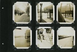
Scrapbook of Corporal Wallace – page 8
Fait partie de City of Winnipeg Archives Photograph collection
Page 8 of a photograph scrapbook made by Corporal John Wallace in April 1940. Photographs depict the Queen’s Own Cameron Highlanders of Canada near the Raleigh Apartments at Vaughan Street and Ellice Avenue, Memorial Boulevard (likely at Broadway, facing west with the Mall Hotel in the distance), a road outside Fort Osborne Barracks, and Corporal Wallace at the home of “The Dowlings” (likely on Beaverbrook Street).
Sans titre