
- i01652
- Pièce
- 1930
Fait partie de City of Winnipeg Archives Photograph collection
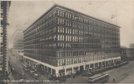
Postcard shows Eaton's department store in foreground. Donald Street annex and mail order building shown in background. Date of postcard is approximate, ca. 1930.
Fait partie de City of Winnipeg Archives Photograph collection
Postcard shows Eaton's department store in foreground. Donald Street annex and mail order building shown in background. Date of postcard is approximate, ca. 1930.

Fait partie de City of Winnipeg Archives Photograph collection
Postcard shows Union Bank building at Main Street and William Avenue. Date of postcard is uncertain, [before 1949].
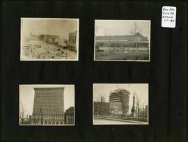
Photograph album of Winnipeg during WW1: Page 4
Fait partie de City of Winnipeg Archives Photograph collection
Item consists of a scrapbook page showing the Eaton's and Boyd Buildings (Item 17), unidentified building (Item 18),
Royal Bank Building and Leland Hotel (Item 19), Construction of Confederation Building with Volunteer Monument in foreground (Item 20). Dates of photographs are approximate, [ca. 1913].

Photograph album of Winnipeg during WW1: Page 5
Fait partie de City of Winnipeg Archives Photograph collection
Item consists of a scrapbook page showing soldiers lined up in military parade in front of the Industrial Bureau Exposition Building (Item 21), soldiers lined up in military parade (Item 22),
soldiers on horse in military parade in front of the Industrial Bureau Exposition Building (Item 23), crowd forming on street in front of the Israelite Jewish Daily newspaper building (975 Main Street) and the H. Lindster's Bakery (971 Main Street). Soldiers and Police in foreground (Item 24), [ca. 1913].

Main Street north of Portage Avenue
Fait partie de City of Winnipeg Archives Photograph collection
Photograph of a muddy Main Street in 1872, facing north from Portage Avenue and lined with shops on both sides, including a provisions store on the very right.

Rossmere Shopping Centre panorama
Fait partie de City of Winnipeg Archives Photograph collection
View of Rossmere Shopping Centre, 1070 Henderson Highway, southwest corner Rowandale, 4.25 acres. From left to right: a garage or car wash, Red River Co-Op Store, Rossmere Lanes Bowling Alley, Library, Dry Cleaners, Co-operators Credit Union Society Limited, Rowandale Baptist Church, Rowandale Apartments, Red River Co-Op Gas Station. Consists of 3 separate photographs pasted together on cardboard to create a panorama. The cardboard is a scrap made from an old sign of the Metropolitan Corporation of Greater Winnipeg (visible on the reverse). The cardboard is numbered “2”, presumably as part of a compilation with other shopping centre panoramas.
Sans titre

Southgate Shopping Centre panorama
Fait partie de City of Winnipeg Archives Photograph collection
View of Southgate Village Shopping Centre, 1305-1341 Pembina Highway at the southwest corner of McGillivray Boulevard, 3.3 acres. From left to right: Pembina Curling Rink, Imperial Cleaners, Safeway, The Place, Young Togs, Reid Marshall Pharmacy, The Village Gift Shop, The French Salon, Marshall Wells, The Toronto Dominion Bank, Safeway gas bar. Consists of 3 separate photographs pasted together on cardboard to create a panorama. The cardboard is a scrap made from an old sign of the Metropolitan Corporation of Greater Winnipeg (visible on the reverse). The cardboard is numbered “7”, presumably as part of a compilation with other shopping centre panoramas.
Sans titre

Westwood Shopping Centre panorama
Fait partie de City of Winnipeg Archives Photograph collection
View of Westwood Shopping Centre, 3276-3332 Portage Avenue, 10.2 acres. From left to right: various shops, motel, various shops and Assiniboia Public Library, Safeway Store, Marshall Wells, Perths, Westwood Pharmacy, various Shops, Zeller's County Fair, Auto Centre. Consists of 3 separate photographs pasted together on cardboard to create a panorama. The cardboard is a scrap made from an old sign of the Metropolitan Corporation of Greater Winnipeg (visible on the reverse). The cardboard is numbered “10”, presumably as part of a compilation with other shopping centre panoramas.
Sans titre

Arthur and Fred Landen photograph album – page 26
Fait partie de City of Winnipeg Archives Photograph collection
Page 26 of a photograph album created by brothers Arthur and Fred Landen of Hull, England. Page consists of 6 photographs taken by Fred Landen depicting, clockwise from top-left: Winnipeg’s second City Hall and the Volunteer Monument (which is captioned “Scott’s Monument, Fish Creek”); the Osborne Bridge over the Assiniboine River; a horse drawn sleigh carrying cords of wood in front of City Hall; a large house on Broadway, a dog sleigh in front of H. Laffrezen's Central Bakery at 333 1/2 William Avenue; and floating ice on the Assiniboine River.
Sans titre
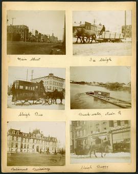
Arthur and Fred Landen photograph album – page 29
Fait partie de City of Winnipeg Archives Photograph collection
Page 29 of a photograph album created by brothers Arthur and Fred Landen of Hull, England. Page consists of 6 photographs taken by Fred Landen depicting, clockwise from top-left: Main Street facing north from McDermot Avenue; a horse-drawn sleigh carrying a large block of ice in front of the Transit Hotel on Notre Dame Avenue East (now Pioneer Avenue); break-water on the Assiniboine River with houses in the distance; women in sleigh buggy in front of storefronts on Main Street, between Portage and Graham Avenues; the old Manitoba Parliament Building; and a horse-drawn sleigh bus advertising the Vendome Hotel in front of the Commonwealth Block on Main Street and Market Avenue.
Sans titre
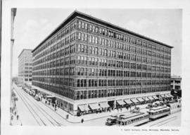
T. Eaton Comapny Store, Winnipeg, Manitoba, Canada
Fait partie de City of Winnipeg Archives Photograph collection
Print shows a photographic image of the Eaton's Store in downtown Winnipeg. Date of print is uncertain, [193-?].

VE Day - Hurtig Furs store decorated with victory sign
Fait partie de City of Winnipeg Archives Photograph collection
Photograph shows Hurtig Furs store on Portage Avenue, storefront decorated with victory sign for Victory in Europe (VE Day) celebrations that marked the end of World War 2 in Europe.
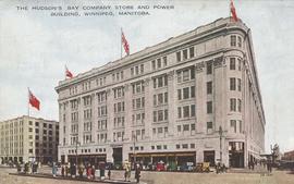
The Hudson's Bay Company Store and Power Building, Winnipeg, Manitoba
Fait partie de City of Winnipeg Archives Photograph collection
Item consists of a postcard in printed format that shows the HBC Department Store "the Bay" at Portage Avenue and Memorial Boulevard. The Power Building appears at left-side of postcard. Published by Valentine Edy Company, Limited, Winnipeg, Manitoba. Printed in Great Britain. Date of postcard is unknown.
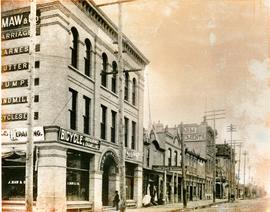
South West Corner of King and William
Fait partie de City of Winnipeg Archives Photograph collection
Item is a photographic reproduction, date unknown (original created ca. 1900). Shows the south west corner of King Street and William Avenue.
Photograph album of Winnipeg during WW1: Page 3
Fait partie de City of Winnipeg Archives Photograph collection
Item consists of a scrapbook page showing the Young Men's Christian Association (YMCA) Building at 301 Vaughan Street (Item 13); view of Portage Avenue with Eaton's and Boyd buildings in foreground and Hotel Fort Garry in the background (Item 14); view of Ashford's Bakery at Portage Avenue and Furby Street, facing south towards Broadway (Item 15); Vaughan Street facing north towards St. Paul's College on Ellice Avenue (Item 16). Dates of photographs are approximate, [ca. 1913].

Photograph album of Winnipeg during WW1: Page 6
Fait partie de City of Winnipeg Archives Photograph collection
Item consists of a scrapbook page showing soldiers marching in military parade on street in front of the Elliott and Hazel Grocers, 975 Main Street and the H. Lindster's Bakery, 971 Main Street (Item 25), soldiers lined up in military parade (Item 26),
soldiers marching in military parade (Item 27), soldiers marching in military parade (Item 28), [ca. 1913].

Storefronts on Portage Avenue between Carlton and Hargrave Streets
Fait partie de City of Winnipeg Archives Photograph collection
Cars and shoppers in front of stores on the north side of Portage Avenue, between Carlton and Hargrave Streets. Featured are The Berryhill Shoe Store in the Enderton / Mitchell-Copp Building, the Bank of Montreal, and Zeller's (Zellers).

Portage Avenue looking west from Colony Street
Fait partie de City of Winnipeg Archives Photograph collection
A view of Portage Avenue looking west from Colony Street. The Hudson's Bay Company Building is featured prominantly and the Power Building is visible farther west. Playing "Young Mr. Lincoln", the Gaiety Theatre can be seen across the street with two poli

Northdale Shopping Centre panorama
Fait partie de City of Winnipeg Archives Photograph collection
View of Northdale Shopping Centre, 963 Henderson Highway, 7.65 acres. From left to right: Loblaws Groceteria, Zeller's County Fair, various shops, the Royal Bank, the Canadian Imperial Bank of Commerce, A & P Food Store, Lord Wolseley School. Consists of 3 separate photographs pasted together on cardboard to create a panorama. The cardboard is a scrap made from an old sign of the Metropolitan Corporation of Greater Winnipeg (visible on the reverse). The cardboard is numbered “1”, presumably as part of a compilation with other shopping centre panoramas.
Sans titre

Crossroads Shopping Centre panorama
Fait partie de City of Winnipeg Archives Photograph collection
View of Crossroads Shopping Centre, 1580 Regent Avenue W., 18 acres. From left to right: Woolco Department Store, Various shops, Safeway, Pacific 66 Gas Bar. Consists of 3 separate photographs pasted together on cardboard to create a panorama. The cardboard is a scrap made from an old sign of the Metropolitan Corporation of Greater Winnipeg (visible on the reverse). The cardboard is numbered “3”, presumably as part of a compilation with other shopping centre panoramas.
Sans titre