
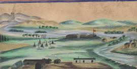
Watercolour depicting early Winnipeg (Fort Garry)
- i01738
- Item
- 1880
Watercolour depicting early Winnipeg (Fort Garry)
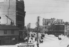
Winnipeg Street Railway on Portage Avenue in front of Merchants Hotel

Main Street Winnipeg looking south from City Hall
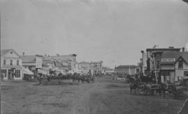
View of Main Street looking north
City of Winnipeg businesses shown in photograph: George Ashdown Hardware, Davis House, Symonds Furrier, Gable Hotel, J. Lister, Outfitter, Rossin House, the Blue Store, and the first City Hall is shown in background.
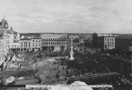
Central view at unveiling Volunteer Monument, Winnipeg, Sept. 28, 1886
Photograph shows unveiling of Volunteer Monument (or Soldiers Monument) on September 28, 1886.
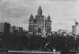
Ceremonies at Unveiling Volunteer Monument, Winnipeg, Sept. 28th, 1886
Photograph shows Winnipeg's second City Hall (1886-1962) and Volunteer Monument (or Soldiers Monument).

Butcher's turnout in Market Square
Photograph of a large group, many on horseback, gathered for what the photograph's caption calls a "butcher's turnout" at the northwest corner of King Street and Market Avenue (the north side of Market Square). Photograph was taken by Israel Bennetto and has come apart into two pieces.
Bennetto, Israel
Part of Morris Block collection
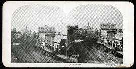
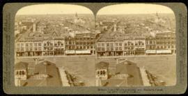
Stereogram showing a view of Main Street north of Portage Avenue.
Block, Morris

Waghorn's Guide map and street index
Part of City Clerk's Library collection
Waghorn's Guide - a small promotional pamphlet published by J.R. Waghorn in 1895. The pamphlet contains a street map of Winnipeg, a street index, and advertisements for various Winnipeg businesses including the Clarendon Hotel, the Redwood Brewery, and the Massey-Harris Company. The map shows the old City of Winnipeg from the Red River on the east to Waverly, Aubrey, and McPhillips Streets on the west, and from Athole Avenue (now Luxton Avenue) in the north to Parker Avenue in the south. Southern Elmwood, Old St. Boniface, and Norwood are also shown on the east side of the river. Railway lines are in black and electric street railway lines are in red.
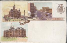
Canadian Postal Card showing Winnipeg City Hall, Main Street and Parliament Buildings
Postcard shows Winnipeg's second city hall (1886-1962), Main Street and Parliament buildings.
Telfer Block, 156 Lombard Avenue
Part of City of Winnipeg (1874-1971)
Item is part of small album containing photographs of maps tracking the outbreak of typhoid from 1905 to 1908. Item is loose and at back of album. Date of item is approximate, [circa 1905].
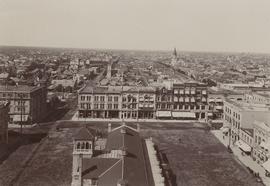
Birdseye view of Winnipeg – looking west from City Hall
Part of Morris Block collection
A promotional stereogram of Market Square, facing west from City Hall, made by Underwood and Underwood Publishers. The reverse side describes the scene in 6 languages.
Block, Morris
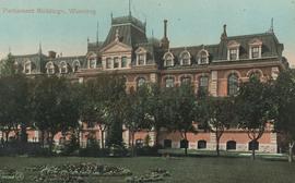
Parliament Buildings, Winnipeg
Postcard shows Provincial Parliament Building located on Kennedy Street, southwest corner of Broadway (former Manitoba Legislative Building, now demolished). Date of postcard is uncertain, [before 1921].
Winnipeg looking west from the tower of City Hall
Winnipeg looking west from the tower of City Hall, September 5, 1900. Present site of Red River College's Princess Street campus. Campus design included stabilization of five historic building facades along Princess Street: right to left from the corner of Elgin Avenue and Princess Street, the Utility Building (Winnipeg's first Grain Exchange) at 164 Princess; the Exchange Building II at 160 Princess; the Harris Building (Hochman's) at 154 Princess; the Bawlf Block at 150 Princess; and the Drake Hotel (Benson Block) at 146 Princess.

Visit of Duke and Duchess or Cornwall & York (George V and Queen Mary)
Photograph showing the Duke and Duchess of Cornwall and York, George V and Queen Mary, at Winnipeg City Hall.

Visit of Duke and Duchess of Cornwall & York (George V and Queen Mary)
Photograph showing an arch built near the C.P.R. Station in honour of a visit by the Duke and Duchess of Cornwall & York, George V and Queen Mary.

Page shows five street views of Winnipeg, ca. 1903: 1) Main Street from Commercial Club, 2) Elgin Avenue, 3) Geo. Velie, Wholesale Wines and Liquors, 4) William Avenue, looking west, and 5) Main Street, looking north from Portage Avenue.

Arthur and Fred Landen photograph album – page 26
Page 26 of a photograph album created by brothers Arthur and Fred Landen of Hull, England. Page consists of 6 photographs taken by Fred Landen depicting, clockwise from top-left: Winnipeg’s second City Hall and the Volunteer Monument (which is captioned “Scott’s Monument, Fish Creek”); the Osborne Bridge over the Assiniboine River; a horse drawn sleigh carrying cords of wood in front of City Hall; a large house on Broadway, a dog sleigh in front of H. Laffrezen's Central Bakery at 333 1/2 William Avenue; and floating ice on the Assiniboine River.
Landen, Frederick Cluett
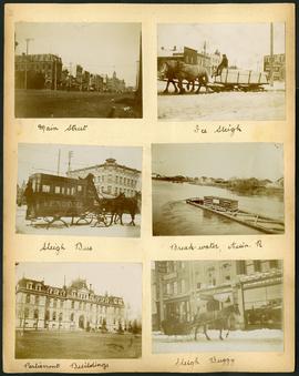
Arthur and Fred Landen photograph album – page 29
Page 29 of a photograph album created by brothers Arthur and Fred Landen of Hull, England. Page consists of 6 photographs taken by Fred Landen depicting, clockwise from top-left: Main Street facing north from McDermot Avenue; a horse-drawn sleigh carrying a large block of ice in front of the Transit Hotel on Notre Dame Avenue East (now Pioneer Avenue); break-water on the Assiniboine River with houses in the distance; women in sleigh buggy in front of storefronts on Main Street, between Portage and Graham Avenues; the old Manitoba Parliament Building; and a horse-drawn sleigh bus advertising the Vendome Hotel in front of the Commonwealth Block on Main Street and Market Avenue.
Landen, Frederick Cluett
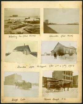
Arthur and Fred Landen photograph album – page 32
Page 32 of a photograph album created by brothers Arthur and Fred Landen of Hull, England. Page consists of 6 photographs taken by Fred Landen depicting, clockwise from top-left: ice floating on the Red River; a grain elevator on the banks of the Red River; a house buried in snow after the blizzard on February 8 and 9, 1905; a horse-drawn delivery sleigh from Imperial Dry Goods on Main Street in front of the old post office and the Conklins Land Office; a horse-drawn sleigh cab possibly outside the Assiniboine Block/Empire Hotel on Main Street; and another small house buried in snow after the blizzard on February 8 and 9, 1905.
Landen, Frederick Cluett