
- i00793
- Item
- 1950
Part of City of Winnipeg (1874-1971)
A photograph taken during the 1950 flood, showing Wellington by Maryland Bridge. Item is 1 of 8 photographs on page 90 of scrapbook.
Harold K. White Studio
23 results with digital objects Show results with digital objects
Part of City of Winnipeg (1874-1971)
A photograph taken during the 1950 flood, showing Wellington by Maryland Bridge. Item is 1 of 8 photographs on page 90 of scrapbook.
Harold K. White Studio

Waghorn's Guide map and street index
Part of City Clerk's Library collection
Waghorn's Guide - a small promotional pamphlet published by J.R. Waghorn in 1895. The pamphlet contains a street map of Winnipeg, a street index, and advertisements for various Winnipeg businesses including the Clarendon Hotel, the Redwood Brewery, and the Massey-Harris Company. The map shows the old City of Winnipeg from the Red River on the east to Waverly, Aubrey, and McPhillips Streets on the west, and from Athole Avenue (now Luxton Avenue) in the north to Parker Avenue in the south. Southern Elmwood, Old St. Boniface, and Norwood are also shown on the east side of the river. Railway lines are in black and electric street railway lines are in red.
Under construction, Oakwood Street
Part of City of Winnipeg (1874-1971)
A photograph taken during the 1950 flood, showing Oakwood Street under construction. Item is 1 of 7 photographs on page 25 of scrapbook.
Harold K. White Studio

Thoroughfares: Academy Road at Wellington Crescent
View of cars and cyclists heading down Academy Road towards Wellington Crescent and the Maryland Bridge. The cupola of Misericordia Hospital can be seen across the bridge.

Thoroughfares: Academy Road at Wellington Crescent
View of cars and cyclists heading down Academy Road towards Wellington Crescent and the Maryland Bridge. A small portion of Misericordia Hospital can be seen across the bridge.
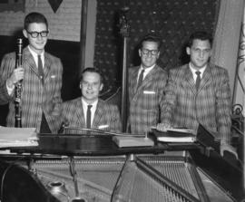
The Jose Poneira Quartet at The Rancho Don Carlos
Part of Owen Clark collection
Photograph shows the Jose Poneira Quartet at the Rancho Don Carlos. From left to right: Jimmy Weber, Jose Poneira, Jim Cordupel and Ed Sersen.
S.W. Corner Arnold & Mabel (62?)
Part of City of Winnipeg (1874-1971)
A photograph taken during the 1950 flood, showing the southwest corner of Arnold Avenue and Mabel Avenue and possibly 62 Arnold Avenue. Item is 8 of 8 photographs on page 1 of scrapbook.
Harold K. White Studio
S.E. Corner Arnold Avenue (100 Arnold?)
Part of City of Winnipeg (1874-1971)
A photograph taken during the 1950 flood, showing the southeast corner of Arnold Avenue and possibly 100 Arnold Avenue. Item is 7 of 8 photographs on page 1 of scrapbook.
Harold K. White Studio

Part of Owen Clark collection
Group of musicians eating dinner at Don Carlos Casino with Johnny Bering standing in rear
Part of City of Winnipeg (1874-1971)
A photograph of a flooded underpass on Pembina Highway during the 1950 flood in Winnipeg.
Harold K. White Studio
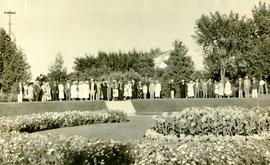
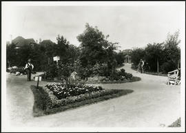
Photograph shows people gathered near a flower garden at Pembina Park (now known as Fisher Park). Date of photograph is 1938.
New house, 129, 133, 137, 143 and 145 Maplewood Avenue
Part of City of Winnipeg (1874-1971)
A photograph taken during the 1950 flood, showing 129 Maplewood Avenue and 133 Maplewood Avenue and 137 Maplewood Avenue and 143 Maplewood Avenue and 145 Maplewood Avenue. Item is 3 of 5 photographs on page 22 of scrapbook.
Harold K. White Studio
Negatives - 2 views ? Baltimore Road
Part of City of Winnipeg (1874-1971)
Negatives - 2 views ? Baltimore Road Item is 6 of 6 negatives on page 27 of scrapbook.
Harold K. White Studio
Part of City of Winnipeg (1874-1971)
A photograph taken during the 1950 flood, showing Morley Avenue Grocery located @ Morley and Fisher. Item is 2 of 8 photographs on page 11 of scrapbook.
Harold K. White Studio
Part of City of Winnipeg (1874-1971)
A photograph taken during the 1950 flood, showing Mayfair Apartments. Item is 2 of 5 photographs on page 86 of scrapbook.
Harold K. White Studio
Part of City of Winnipeg (1874-1971)
A photograph taken during the 1950 flood, showing Mabel Street. Item is 5 of 7 photographs on page 13 of scrapbook.
Harold K. White Studio
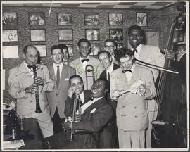
Louis Armstrong's Band at Rancho Don Carlos
Part of Owen Clark collection
Autographed photo of Louis Armstrong's band at Rancho Don Carlos. Photograph shows (L-R): Barney Bigard, George Reznick, Larry Schwartz, Trummy Young, Johnny Bering, Carl Riller, Kenny John, Arvel Shaw. (Seated, L-R): Charlie Mazzone, Louis Armstrong. Date of photograph is uncertain, taken in late 1940s.
![Legislative Building and Central Winnipeg [Aerial view]](/uploads/r/city-of-winnipeg-archives-amp-records-control-branch/5/1/1/511af88a9e92fe7d7d3edda2bdaee6fc5652013532efb88411d3403dfcf85917/C0013_0000_0000_P0018_0046_001_142.jpg)
Legislative Building and Central Winnipeg [Aerial view]
Inscription (on recto): WG M35: 4-5, 5 Mar '45, Legislative Bldg and Central Wpg, appr. scale 1/12000.

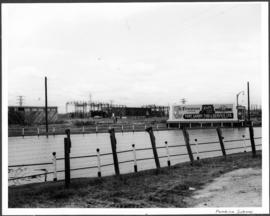
Grant Plaza Shopping Centre panorama
View of Grant Park Plaza Shopping Centre, 1200-1216 Grant Avenue, 13.2 acres. From left to right: Clarks Discount Store, Dominion Store, Liquor Commission, Clarks Auto Centre. Consists of 3 separate photographs pasted together on cardboard to create a panorama. The cardboard is a scrap made from an old sign of the Metropolitan Corporation of Greater Winnipeg (visible on the reverse). The cardboard is numbered “8”, presumably as part of a compilation with other shopping centre panoramas.
Metropolitan Corporation of Greater Winnipeg (Man.). Planning Division