
William Smaill Photo Album – Page 55
- p00173
- Part
- [1914 or 1915]
Part of William Smaill fonds
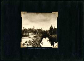
Captions read: Engineer's residence, boggy number 1.
Smaill, William
81 results with digital objects Show results with digital objects
William Smaill Photo Album – Page 55
Part of William Smaill fonds
Captions read: Engineer's residence, boggy number 1.
Smaill, William

William Smaill Photo Album – Page 46
Part of William Smaill fonds
Captions read: Vera S. - "EH?", "OH?" - Our home at Whitemouth River - Elsie.
Smaill, William

William Smaill Photo Album – Page 37
Part of William Smaill fonds
Captions read: Blaw Forms - Camp 2, Mile 57, Rear View - 8 foot clear muskeg - Camp 2, front view.
Smaill, William
William Smaill Photo Album – Page 29
Part of William Smaill fonds
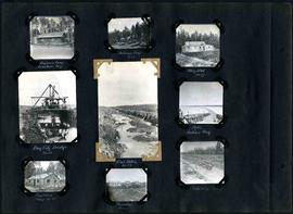
Captions read: Engineer's camp, Birch River, mile 77 - Sailman's camp, mile 88 - Hospital, mile 77 - Bay City dredge, mile 89 - Pilot ditch, mile 89 - Dyke, Indian Bay - Engineer's camp, mile 88 - Tremblays camp 1 - Mile 85.5, '16.
Smaill, William

William Smaill Photo Album – Page 19
Part of William Smaill fonds
Captions read: Tomlison and Pleming's camp - Ballast trains - Birch River - Clearing land, Whtiemouth - Class 14 pads - Lidgerwood - Unloading boom - Camp 5, April 14 - Work train - McLerie's - Deacon - Hand cars - Culverts, mile 57 - Hunter and Jack Cumm
Smaill, William

William Smaill Photo Album – Page 13
Part of William Smaill fonds
Captions read: Jackfish - Whitemouth - Trail, Indian Bay - Whitemouth - Birch River - Whitemouth - McLerie's.
Smaill, William

William Smaill Photo Album – Page 9
Part of William Smaill fonds
Captions read: Station men's shack - Boggy number 1 - Hadashville - Settlers' house - Whitemouth - camp 3 - Indian Bay, April 1914.
Smaill, William
Photograph album of Winnipeg during WW1: Page 2
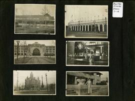
Item consists of a scrapbook page showing unidentified building (Item 7), Industrial Bureau Exhibition Building (Item 8), Canadian National Railway station (C.N.R. station) from Broadway looking east (Item 9), unidentified woman standing in front of residential building (Item 10), City Hall and Volunteer Monument (second City Hall) (Item 11), unidentified woman posing in front of what is likely the Assiniboine Park Pavilion (Item 12). Dates of photographs are approximate, [ca. 1913].

Apartment block at 415 Edison Avenue
Apartment block at 415 Edison Avenue, near Rothesay Street.
Part of Morris Block collection
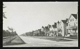
Photograph of houses on Edmonton Street, likely south of Portage Avenue.
Block, Morris

Aerial of 1974 Flood – Fraser’s Grove Park
Aerial photograph of the Red River during the 1974 Flood. The photograph faces southwest from Fraser’s Grove Park and Kildonan Drive in East Kildonan towards Scotia Street in the Seven Oaks area of West Kildonan. The photographs were taken by the Department of Environmental Planning.
Winnipeg (Man.). Department of Environmental Planning

Aerial of 1974 Flood – Pritchard Avenue Boat Dock and Redwood Bridge
Aerial photograph of the Red River during the 1974 Flood. The photograph faces northwest towards the North End, with the Pritchard Avenue Boat Dock in the bottom left and the Redwood Bridge in the top right. The photographs were taken by the Department of Environmental Planning.
Winnipeg (Man.). Department of Environmental Planning

Aerial of 1974 Flood – Bergen Cutoff Bridge
Aerial photograph of the Bergen Cutoff Bridge during the 1974 Flood. The photograph faces northwest from Kildonan Drive in North Kildonan across the Red River towards Kildonan Park and Old Kildonan. The photographs were taken by the Department of Environmental Planning.
Winnipeg (Man.). Department of Environmental Planning

Aerial of 1974 Flood – Red River between North and West Kildonan
Aerial photograph of the Red River during the 1974 Flood. The photograph faces west from North Kildonan, where the Chief Peguis Trail now stands, across the river towards Kildonan Park and West Kildonan on the left, the North End Water Treatment Plant in the middle, and Old Kildonan on the right. The photographs were taken by the Department of Environmental Planning.
Winnipeg (Man.). Department of Environmental Planning

Aerial of 1974 Flood – Red River between East and West Kildonan
Aerial photograph of the Red River during the 1974 Flood. The photograph faces northwest from around Helmsdale Avenue and Kildonan Drive in East Kildonan towards Scotia Street in the Seven Oaks area of West Kildonan across the river. The photographs were taken by the Department of Environmental Planning.
Winnipeg (Man.). Department of Environmental Planning
Arthur and Fred Landen photograph album
Photograph album created by brothers Arthur and Fred Landen of Hull, England. Consists of circa 150 photographs of Arthur Landen’s time as Honourable Lieutenant and Quartermaster in the 1st Battalion of the Northumberland Fusiliers while stationed in Spain, Gibraltar, Egypt, and elsewhere in Africa between 1887 and 1907, as well as circa 40 photographs of Fred Landen’s stay in Winnipeg between 1903 and 1906 and his home in Hull, England. Winnipeg photographs feature homes, commercial buildings, and modes of transporation. The pages are loose and many of the photographs are faded.
Landen, Frederick Cluett
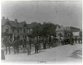
Horses and men leading novelty carriage
Photograph of a cavalcade of horses and men in suits leading a carriage made of hay[?] down an unknown, partially residential street.
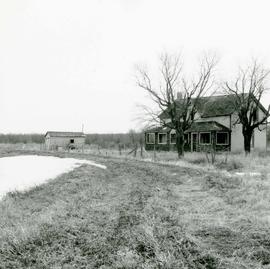
Area of John Blumberg Golf Course prior to construction.
Photograph of abandoned buildings on a rural stretch of land in the area of what is now John Blumberg Golf Course. A description of the photo used for publication is recorded on a separate piece of paper. Photo's reverse is stamped by the Parks and Protection Division of the Metro Government.
Metropolitan Corporation of Greater Winnipeg (Man.). Information Officer
An album page with a photograph on each side. The photographs depict a Parks Board supervised skating rink outside the Northland Knitting Company at 618 Arlington Street on each side.
Four photographs affixed two to each side of a page of construction paper. The two photos on the first side depict children playing at the Scotia Rink, while those on the second depict children on a swing set and eating ice cream.