

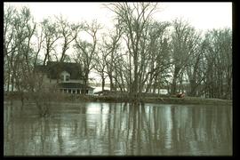
Winnipeg Boat Club under water, Norwood, April 1916
- i01453
- Item
- 1916
Postcard is a photographic print. Photograph taken by Advance Photo Company, Winnipeg. Azo mark appears in stamp box, made in Canada.
355 results with digital objects Show results with digital objects
Winnipeg Boat Club under water, Norwood, April 1916
Postcard is a photographic print. Photograph taken by Advance Photo Company, Winnipeg. Azo mark appears in stamp box, made in Canada.

Item is a photographic reproduction of map showing various sewer system details. Stamp (on verso): City of Winnipeg - Engineering Dept., Water Works Division, Ross and Tecumseh.


Aerial of 1974 Flood – Red River between East and West Kildonan
Aerial photograph of the Red River during the 1974 Flood. The photograph faces northwest from around Helmsdale Avenue and Kildonan Drive in East Kildonan towards Scotia Street in the Seven Oaks area of West Kildonan across the river. The photographs were taken by the Department of Environmental Planning.
Winnipeg (Man.). Department of Environmental Planning

Aerial of 1974 Flood – Pritchard Avenue Boat Dock and Redwood Bridge
Aerial photograph of the Red River during the 1974 Flood. The photograph faces northwest towards the North End, with the Pritchard Avenue Boat Dock in the bottom left and the Redwood Bridge in the top right. The photographs were taken by the Department of Environmental Planning.
Winnipeg (Man.). Department of Environmental Planning

Aerial of 1974 Flood – Fraser’s Grove Park
Aerial photograph of the Red River during the 1974 Flood. The photograph faces southwest from Fraser’s Grove Park and Kildonan Drive in East Kildonan towards Scotia Street in the Seven Oaks area of West Kildonan. The photographs were taken by the Department of Environmental Planning.
Winnipeg (Man.). Department of Environmental Planning

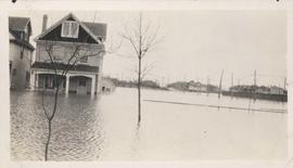
Women standing on flooded residential street with men in canoe, 1916 Flood, Norwood
Photograph shows scene from the 1916 flooding of the Assiniboine River in Norwood, two unidentified women standing on flooded residential street in foreground with two unidentified men paddling in canoe behind them.
Flood water over front porch of home, 1916 Flood, Norwood
Photograph shows scene from the 1916 flooding of the Assiniboine River in Norwood, flood water levels high enough to submerge front porch of home on left side of photograph.

Wildwood Park - Three weeks before flood, 1950

Colony Street and Whitehall Avenue
Photograph is one of five photos mounted on page with caption "Assiniboine River flooded, Spring 1916."

Part of Winnipeg Flood Record and Archives Committee collection
A photograph of 201 Kingston Row during the 1997 flood.
Winnipeg (Man.). Community Services Department
1997 flood - Kingston Row - house
Part of Winnipeg Flood Record and Archives Committee collection
A photograph of a house on Kingston Row during the 1997 flood.
Winnipeg (Man.). Community Services Department

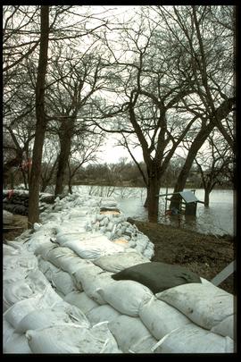
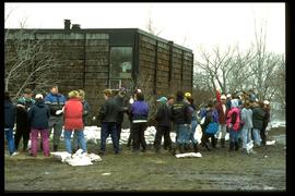
1997 flood - Kingston Crescent - sandbagging operations
Part of Winnipeg Flood Record and Archives Committee collection
A photograph of a pile of sandbags in a playground on Kingston Crescent during the 1997 flood.
Winnipeg (Man.). Community Services Department
1997 flood - Elm Park Bridge and dike
Part of Winnipeg Flood Record and Archives Committee collection
A photograph of a sandbag dike along the Red River close to the Elm Park Bridge during the 1997 flood.
Winnipeg (Man.). Community Services Department

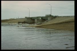
1997 flood - Highway 75 - south view from dike
Part of Winnipeg Flood Record and Archives Committee collection
A photograph of flooding over Highway 75, looking south from a dike.
Winnipeg (Man.). Community Services Department

1997 flood - Highway 75 - north view from dike
Part of Winnipeg Flood Record and Archives Committee collection
A photograph of Highway 75, looking north from a dike. Trucks and military vehicles can be seen.
Winnipeg (Man.). Community Services Department
1997 flood - Floodway gates on Red River
Part of Winnipeg Flood Record and Archives Committee collection
A photograph of the open floodway gates, water rushing through them, on the Red River during the 1997 flood.
Winnipeg (Man.). Community Services Department
1997 flood - Turnbull Drive - house
Part of Winnipeg Flood Record and Archives Committee collection
A photograph of a house on Turnbull Drive, surrounded by dikes and water, during the 1997 flood.
Winnipeg (Man.). Community Services Department
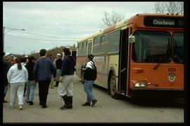
1997 flood - Turnbull Drive - sandbaggers leaving a bus
Part of Winnipeg Flood Record and Archives Committee collection
A photograph of volunteer sandbaggers disembarking from a chartered city bus on Turnbull Drive during the 1997 flood.
Winnipeg (Man.). Community Services Department
1997 flood - Turnbull Drive - sandbaggers
Part of Winnipeg Flood Record and Archives Committee collection
A photograph of a human chain of volunteer sandbaggers on Turnbull Drive during the 1997 flood.
Winnipeg (Man.). Community Services Department