
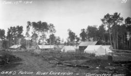
Contractor's camp at Indian Bay
- i01190
- Item
- 1914
Photograph of Greater Winnipeg Water District contractor Tomlinson and Fleming's camp at Indian Bay. Photograph taken by Douglas L. McLean.
Greater Winnipeg Water District
29 results with digital objects Show results with digital objects
Contractor's camp at Indian Bay
Photograph of Greater Winnipeg Water District contractor Tomlinson and Fleming's camp at Indian Bay. Photograph taken by Douglas L. McLean.
Greater Winnipeg Water District
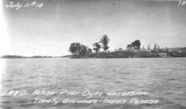
Treaty Grounds - Kekekoziibii Shoal Lake 40 First Nation
Photograph of Kekekoziibii (Shoal Lake 40) First Nation camp at Shoal Lake. Photograph taken from the Falcon River Diversion Dyke by William G. Chace, Chief Engineer of the Winnipeg Aqueduct.
Greater Winnipeg Water District
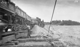
Placing material on Falcon River Diversion Dyke at Indian Bay
Photograph of workers using a scow to place material from cars onto the Falcon River Diversion Dyke at Indian Bay. Photograph taken by William G. Chace, Chief Engineer of the Winnipeg Aqueduct.
Greater Winnipeg Water District
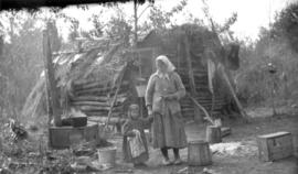
Only station woman on GWWD railway construction
Photograph of the only station woman for the construction of the Greater Winnipeg Water District Railway holding the hand of a child in front of a shelter, possibly near Shoal Lake. Photograph taken by C.J. Bruce, one of the Division Engineers for the Winnipeg Aqueduct.
Greater Winnipeg Water District
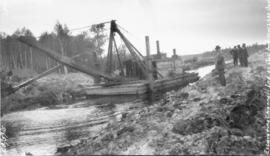
Excavating Falcon River Diversion Canal at Shoal Lake
Photograph of a dredge excavating the Falcon River Diversion Canal between Indian Bay and Snowshoe Bay, with consulting Engineer James H. Fuertes standing to the right. Photograph is looking northwest and the photographer is unknown.
Greater Winnipeg Water District
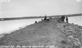
Riprapping west side of Falcon River Diversion Dyke at Indian Bay
Photograph of workers riprapping the west side of the Falcon River Diversion Dyke at Indian Bay. Photographer is unknown.
Greater Winnipeg Water District
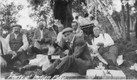
Aqueduct officials party at Indian Bay
Photograph of Winnipeg Aqueduct officials and their families having a picnic at Indian Bay. The men in the foreground, from left to right: unknown, Controller John James Wallace, Controller John William Astley, "Irving" [caption on negative], St. Boniface Mayor John Power Howden[?], "Shamin" [caption on negative], unknown. Photographer unknown.
Greater Winnipeg Water District
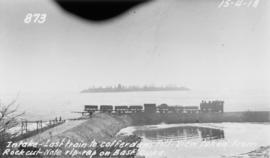
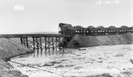
Last train to cofferdam at aqueduct intake at Indian Bay
Photograph of the last train to go to the cofferdam at the Winnipeg Aqueduct's intake at Indian Bay, taken from the rock cut. Photographer is unknown.
Greater Winnipeg Water District
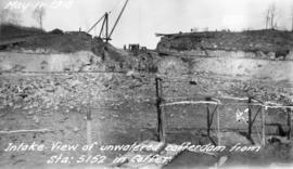
Empty cofferdam for aqueduct intake near Indian Bay
Photograph of an empty cofferdam near the Winnipeg Aqueduct's intake at Indian Bay. Photographer is unknown.
Greater Winnipeg Water District
Filling in cofferdam for aqueduct's intake at Indian Bay
Photograph of dump cars filling in last gap of a cofferdam between dykes at the intake of the Winnipeg Aqueduct at Indian Bay, taken from the west dyke. Photographer is unknown.
Greater Winnipeg Water District
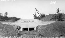
Front wall of aqueduct's intake at Indian Bay
Photograph of the front wall, skimming, and channel of the Winnipeg Aqueduct's intake at Indian Bay, looking west. Photographer is unknown.
Greater Winnipeg Water District
L.B. Foote photos of tourists at Shoal Lake
Glass lantern slides taken by L.B. [Lewis Benjamin] Foote of the tourists taking the Greater Winnipeg Water District Railway to and enjoying leisure time at Shoal Lake. The Greater Winnipeg Water District hired Foote to take these photos.
Greater Winnipeg Water District
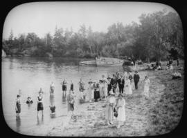
View of bathing beach at Waugh, looking south along beach. Image derived from glass lantern slide.
Greater Winnipeg Water District

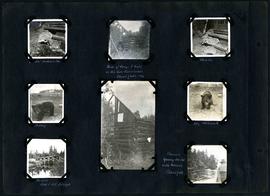
William Smaill Photo Album – Page 9
Part of William Smaill fonds
Captions read: Station men's shack - Boggy number 1 - Hadashville - Settlers' house - Whitemouth - camp 3 - Indian Bay, April 1914.
Smaill, William

William Smaill Photo Album – Page 13
Part of William Smaill fonds
Captions read: Jackfish - Whitemouth - Trail, Indian Bay - Whitemouth - Birch River - Whitemouth - McLerie's.
Smaill, William

William Smaill Photo Album – Page 15
Part of William Smaill fonds
Captions read: Anderson's dredge making cut between Indian Bay and Snowshoe Bay.
Smaill, William
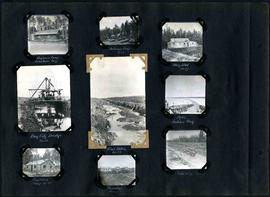
William Smaill Photo Album – Page 29
Part of William Smaill fonds
Captions read: Engineer's camp, Birch River, mile 77 - Sailman's camp, mile 88 - Hospital, mile 77 - Bay City dredge, mile 89 - Pilot ditch, mile 89 - Dyke, Indian Bay - Engineer's camp, mile 88 - Tremblays camp 1 - Mile 85.5, '16.
Smaill, William
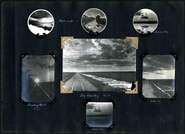
William Smaill Photo Album – Page 30
Part of William Smaill fonds
Captions read: Whitemouth - Indian Bay - Heading west, mile 68 - Big muskeg, mile 91 - Mile 89 - Indian Bay.
Smaill, William
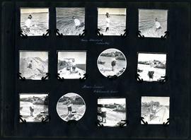
William Smaill Photo Album – Page 48
Part of William Smaill fonds
Captions read: Nancy Blanchard, Indian Bay - Bruce Smaill, Whitemouth River.
Smaill, William
William Smaill Photo Album – Page 49
Part of William Smaill fonds
Captions read: Jumbo[?], Indian Bay - Ruins of camp 1 built on Ontario gold concessions, Shoal Lake, 1896 - Jumbo - Teddy - Teddy, Whitemouth - Birch River railroad bridge - Chasing young ducks with launch, Shoal Lake.
Smaill, William