
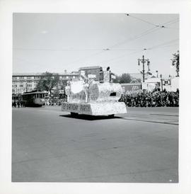
Winnipeg's 75th Anniversary parade - unknown float followed by street cars
- i04265
- Pièce
- 6 Jun. 1949
Fait partie de City of Winnipeg Archives Photograph collection
23 résultats avec objets numériques Afficher les résultats avec des objets numériques
Winnipeg's 75th Anniversary parade - unknown float followed by street cars
Fait partie de City of Winnipeg Archives Photograph collection
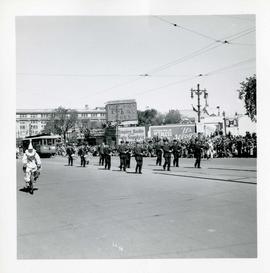
Winnipeg's 75th Anniversary parade - marching band and street car
Fait partie de City of Winnipeg Archives Photograph collection
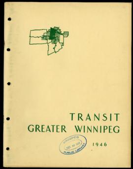
Preliminary Report on Transit - Metropolitan Plan for Greater Winnipeg
Fait partie de City Clerk's Library collection
Item consists of 1 report (43 pages), jointly prepared by the Metropolitan Planning Committee and Winnipeg Town Planning Commission. The report focuses on transit in the Greater Winnipeg Area. Part of the Metropolitan Plan for Greater Winnipeg - number 4 of master plan reports.
Sans titre
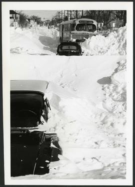
Cars and bus stuck in snow, likely on William Avenue
Fait partie de Metropolitan Corporation of Greater Winnipeg
Photograph of a bus stuck in a snowbank nearly as tall as it, possibly after the blizzard on March 4, 1966. The bus' route is William - Polo Park and this photograph was likely taken on William Avenue. The photographer is unknown. The reverse of the photo asks that it be returned to Transit Publicity.
Sans titre
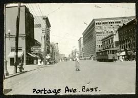
Portage looking east from around Carlton
Fait partie de Morris Block collection
Photograph of a woman crossing Portage Avenue, looking east from around Carlton Street. The Eaton’s building can be seen on the right.
Sans titre
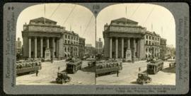
Bank of Montreal building, Portage and Main
Fait partie de Morris Block collection
A promotional stereogram showing traffic and streetcars in front of the Bank of Montreal building at Portage Avenue and Main Street, made by the Keystone View Company. The reverse side of the image contains information about Winnipeg.
Sans titre

For Your Guidance While in Winnipeg promotional map
Fait partie de Morris Block collection
A promotional map created by the Publicity Bureau of Winnipeg and Manitoba titled "For Your Guidance While in Winnipeg". Map was originally folded as a pamphlet, the front page of which features a graphic of two people driving down Highway 14 (now Highway 75) to Winnipeg. The map is not scale and features cartoon depictions of tourist destinations and landmarks around Winnipeg and St. Boniface. The maps shows major streets, railroads, and street railway lines. The map side was originally framed and cut to fit. At a result a small part of the front page is cut off, including a stamp reading "St. Raphael's Ukrainian Immigrants' Welfare Association of Can[ada]".
Sans titre
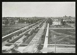
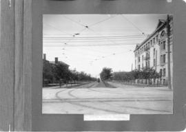
Broadway looking west from Fort Garry Court
Fait partie de Morris Block collection
Photograph taken from Fort Garry Court, located at Broadway and Main Street, looking west down Broadway. St. Mary’s Academy, the Parliament Building (Legislature), and Law Courts are labeled off in the distance.
Sans titre
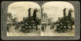
Main Street, looking north from Portage
Fait partie de Morris Block collection
A promotional stereogram showing traffic and streetcars on Main Street, looking north from Portage Avenue, made by the Keystone View Company. The reverse side of the image contains information about Winnipeg.
Sans titre

Scrapbook of Corporal Wallace – page 9
Fait partie de City of Winnipeg Archives Photograph collection
Page 9 of a photograph scrapbook made by Corporal John Wallace in April 1940. Photographs depict a street in Gladstone Manitoba, a trolley bus in Winnipeg on Kennedy Street (between Ellice and Qu'Appelle), and the Butler family, acquaintances of Wallace. See page three of this scrapbook for more details on the Butler family.
Sans titre

Visit of Duke and Duchess of Cornwall & York (George V and Queen Mary)
Fait partie de City of Winnipeg Archives Photograph collection
Photograph showing an arch built near the C.P.R. Station in honour of a visit by the Duke and Duchess of Cornwall & York, George V and Queen Mary.
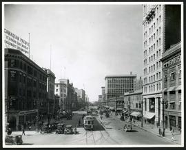
Portage Avenue looking west from Main Street
Fait partie de City of Winnipeg Archives Photograph collection
Date of photograph is approximate, ca. 1927.

Winnipeg Street Railway on Portage Avenue in front of Merchants Hotel
Fait partie de City of Winnipeg Archives Photograph collection

Waghorn's Guide map and street index
Fait partie de City Clerk's Library collection
Waghorn's Guide - a small promotional pamphlet published by J.R. Waghorn in 1895. The pamphlet contains a street map of Winnipeg, a street index, and advertisements for various Winnipeg businesses including the Clarendon Hotel, the Redwood Brewery, and the Massey-Harris Company. The map shows the old City of Winnipeg from the Red River on the east to Waverly, Aubrey, and McPhillips Streets on the west, and from Athole Avenue (now Luxton Avenue) in the north to Parker Avenue in the south. Southern Elmwood, Old St. Boniface, and Norwood are also shown on the east side of the river. Railway lines are in black and electric street railway lines are in red.
Fait partie de Parks and Recreation Photograph collection
A photograph of streetcar on Broadway, looking west from Main Street. The Manitoba Club building can be seen on the left. Photographed by Steele and Company.
Crescentwood Park and Broadway
Fait partie de Parks and Recreation Photograph collection
A photo album page with a view of Crescentwood Park on the first side and a view of Broadway from Main Street on the second side.
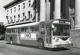
First Western Flyer bus in front of Legislature
Fait partie de Metropolitan Corporation of Greater Winnipeg
Photograph of the first Western Flyer bus used in Winnipeg, parked in front of the Manitoba Legislature Building. The bus is chartered and bears an advertisement on its side for Manitoba's centennial. Publishing information is on the reverse. Unknown photographer.
Sans titre
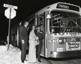
Chartered bus - "Wedding Special"
Fait partie de Metropolitan Corporation of Greater Winnipeg
Photograph of a newly married couple posing with a bus driver in front of a bus parked on Academy Road. The bus has been chartered and is decorated with a sign that says "Wedding Special" on the front. Unknown photographer.
Sans titre
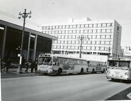
Buses picking up passengers outside City Hall
Fait partie de Metropolitan Corporation of Greater Winnipeg
Photograph of several buses in front of City Hall. One, bound for Portage Avenue and Polo Park, is picking up passengers. The photo is marked "One-way Street" and includes a cut line that reads "...gave way to the new". On the photo's reverse, the make and model of the bus is detailed as follows: Make - GMC, Model - TDH 5301, Year - 1960, Seat Capacity - 51. Photographer is unknown.
Sans titre

Marion buses stuck in snowbank in Windsor Park area
Fait partie de Metropolitan Corporation of Greater Winnipeg
Photograph of two Marion Street buses stuck in snow in the Windsor Park area. The photo is undated, but may be after the blizzard on March 4, 1966. The photographer is unknown. The reverse of the photo asks that it be returned to Transit Publicity.
Sans titre