

Floods - St. Boniface and Norwood - April 1916
- i01450
- Item
- 1916
Postcard is a photographic print showing water flooding homes. Photograph taken by Advance Photo Company, Winnipeg. Azo mark appears in stamp box, made in Canada.
Floods - St. Boniface and Norwood - April 1916
Postcard is a photographic print showing water flooding homes. Photograph taken by Advance Photo Company, Winnipeg. Azo mark appears in stamp box, made in Canada.

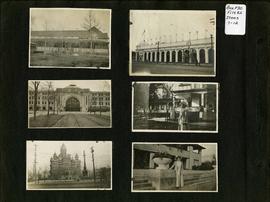
Photograph album of Winnipeg during WW1: Page 2
Item consists of a scrapbook page showing unidentified building (Item 7), Industrial Bureau Exhibition Building (Item 8), Canadian National Railway station (C.N.R. station) from Broadway looking east (Item 9), unidentified woman standing in front of residential building (Item 10), City Hall and Volunteer Monument (second City Hall) (Item 11), unidentified woman posing in front of what is likely the Assiniboine Park Pavilion (Item 12). Dates of photographs are approximate, [ca. 1913].
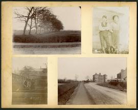
Arthur and Fred Landen photograph album – page 34
Page 34 of a photograph album created by brothers Arthur and Fred Landen of Hull, England. Page consists of 4 photographs taken by Fred Landen depicting, clockwise from top-left: a dirt road and field in Hull, England; two men posing for the camera in Hull, England; a horse drawn cart outside a large house in Hull, England; and a man and woman working in a garden in Hull, England.
Landen, Frederick Cluett

Aerial of 1974 Flood – Red River between East and West Kildonan
Aerial photograph of the Red River during the 1974 Flood. The photograph faces northwest from around Helmsdale Avenue and Kildonan Drive in East Kildonan towards Scotia Street in the Seven Oaks area of West Kildonan across the river. The photographs were taken by the Department of Environmental Planning.
Winnipeg (Man.). Department of Environmental Planning

Aerial of 1974 Flood – Pritchard Avenue Boat Dock and Redwood Bridge
Aerial photograph of the Red River during the 1974 Flood. The photograph faces northwest towards the North End, with the Pritchard Avenue Boat Dock in the bottom left and the Redwood Bridge in the top right. The photographs were taken by the Department of Environmental Planning.
Winnipeg (Man.). Department of Environmental Planning

Aerial of 1974 Flood – Fraser’s Grove Park
Aerial photograph of the Red River during the 1974 Flood. The photograph faces southwest from Fraser’s Grove Park and Kildonan Drive in East Kildonan towards Scotia Street in the Seven Oaks area of West Kildonan. The photographs were taken by the Department of Environmental Planning.
Winnipeg (Man.). Department of Environmental Planning
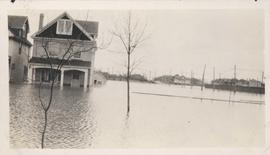
Flood water over front porch of home, 1916 Flood, Norwood
Photograph shows scene from the 1916 flooding of the Assiniboine River in Norwood, flood water levels high enough to submerge front porch of home on left side of photograph.

Wildwood Park - Three weeks before flood, 1950
Date of photograph is approximate, ca. 1914.
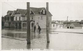
Winnipeg under water - April 1916
Postcard is a photographic print showing water flooding homes likely in St. Boniface. Unknown photographer, Noko mark appears in stamp box.
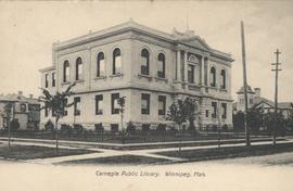
View of Carnegie Library, 380 William Avenue
Shown in background (left) is Francis Cornish residence, in background (right) Victoria School is visible. Date of postcard is approximate, ca. 1905.
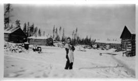
Log cabins at city wood camp, Greater Winnipeg Water District Railway
Photograph shows man standing in front of log cabins used by workers at wood cutting camps. Date of photograph is approximate, ca. 1930.
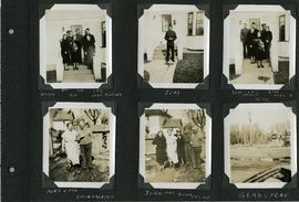
Scrapbook of Corporal Wallace – page 3
Page 3 of a photograph scrapbook made by Corporal John Wallace in April 1940. Photographs depict two families acquainted with Wallace: the Butlers (Jim Sr., Jim Jr., Les, Aggie, Gig, and Mrs. Butler) and the Drinkwaters (Mr. and Mrs. Drinkwater, Joan, Hilda, and Les), as well as Gladstone Manitoba. See general notes section for more details.
Wallace, John

Arthur and Fred Landen photograph album – page 26
Page 26 of a photograph album created by brothers Arthur and Fred Landen of Hull, England. Page consists of 6 photographs taken by Fred Landen depicting, clockwise from top-left: Winnipeg’s second City Hall and the Volunteer Monument (which is captioned “Scott’s Monument, Fish Creek”); the Osborne Bridge over the Assiniboine River; a horse drawn sleigh carrying cords of wood in front of City Hall; a large house on Broadway, a dog sleigh in front of H. Laffrezen's Central Bakery at 333 1/2 William Avenue; and floating ice on the Assiniboine River.
Landen, Frederick Cluett
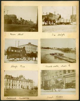
Arthur and Fred Landen photograph album – page 29
Page 29 of a photograph album created by brothers Arthur and Fred Landen of Hull, England. Page consists of 6 photographs taken by Fred Landen depicting, clockwise from top-left: Main Street facing north from McDermot Avenue; a horse-drawn sleigh carrying a large block of ice in front of the Transit Hotel on Notre Dame Avenue East (now Pioneer Avenue); break-water on the Assiniboine River with houses in the distance; women in sleigh buggy in front of storefronts on Main Street, between Portage and Graham Avenues; the old Manitoba Parliament Building; and a horse-drawn sleigh bus advertising the Vendome Hotel in front of the Commonwealth Block on Main Street and Market Avenue.
Landen, Frederick Cluett

Arthur and Fred Landen photograph album – page 31
Page 31 of a photograph album created by brothers Arthur and Fred Landen of Hull, England. Page consists of 6 photographs taken by Fred Landen depicting, clockwise from top-left: shacks in residential area, likely the North End; men lighting a mosquito fire on the banks of the Red River; Fred Landen sitting on the bank of the Red River; a large house with brick veneer; a large house with wood veneer; and a horse-drawn sleigh advertising “A. Hendry. Grocer.” in front of a large house.
Landen, Frederick Cluett

Aerial of 1974 Flood – Bergen Cutoff Bridge
Aerial photograph of the Bergen Cutoff Bridge during the 1974 Flood. The photograph faces northwest from Kildonan Drive in North Kildonan across the Red River towards Kildonan Park and Old Kildonan. The photographs were taken by the Department of Environmental Planning.
Winnipeg (Man.). Department of Environmental Planning

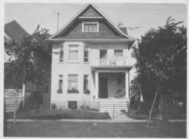
Apartment block at 415 Edison Avenue
Apartment block at 415 Edison Avenue, near Rothesay Street.

Flooded residential street, 1916 Flood, Norwood
Photograph shows scene from the 1916 flooding of the Assiniboine River in Norwood, flooded residential street in view.