
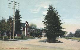
- i01462
- Item
- [194-?]
Postcard includes message from Tab to Beat? on verso. Published by C. S. Co. Ltd., Winnipeg, printed in Saxony.
Postcard includes message from Tab to Beat? on verso. Published by C. S. Co. Ltd., Winnipeg, printed in Saxony.
House flanked by wooden sidewalks

Man in boat rowing down residential street, 1916 Flood, Norwood
Photograph shows scene from the 1916 flooding of the Assiniboine River in Norwood, unidentified man rowing down residential street at center-left of photograph.
![Sandbags - E sec [section] (Wildwood Park - flood, 1950)](/uploads/r/city-of-winnipeg-archives-amp-records-control-branch/c/4/a/c4a7e5ee657f2cf565da1e983d41beae65af0b67f4b9fb5fa71c540b99003de4/C0013_0000_0000_P0022_0094_001_142.jpg)
Sandbags - E sec [section] (Wildwood Park - flood, 1950)
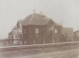
Exterior of home, 146 Spence Street
Photograph is mounted on page with caption "The Old Home - 146 Spence Street." Date of photograph is approximate, ca. 1914.
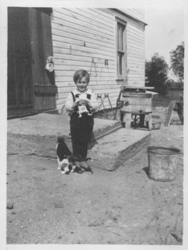
Elva, Manitoba, June 1918, Ken Furtney
Photograph shows child (Ken Furtney) holding kitten, wooden wash tub for laundry in background.
![A corner of our flower bed [146 Spence Street]](/uploads/r/city-of-winnipeg-archives-amp-records-control-branch/8/3/0/8303d86cfc1c3c535a8e5720f2911f54450e682e3755309c35bb6135bc015541/C0013_0000_0000_P0022_0095_055_142.jpg)
A corner of our flower bed [146 Spence Street]
Date of photograph is approximate, ca. 1914.
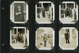
Scrapbook of Corporal Wallace – page 5
Page 5 of a photograph scrapbook made by Corporal John Wallace in April 1940. Photographs depict several acquaintenance of Wallace including two fellow soldiers, “Sonny” Robertson and Joseph “Fuss” McGrath, a Mrs. Penny, and a Frank Dowling and his family. See the general notes section for more details.
Wallace, John
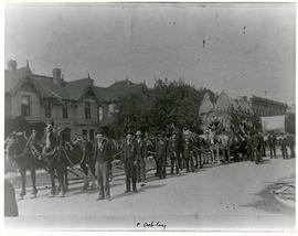
Horses and men leading novelty carriage
Photograph of a cavalcade of horses and men in suits leading a carriage made of hay[?] down an unknown, partially residential street.

Arthur and Fred Landen photograph album – page 28
Page 28 of a photograph album created by brothers Arthur and Fred Landen of Hull, England. Page consists of 6 photographs taken by Fred Landen depicting, clockwise from top-left: bricklayers in front of houses; women on a horse-drawn sleigh (captioned “Cutter”); police in raccoon-skin uniforms; a streetcar crossing the Osborne Bridge; a Ox-drawn sleigh in front of the Royal Oak Hotel in Market Square (Market Avenue and King Street); and a woman pushing a baby in a sleigh in at the northwest corner of Broadway and Kennedy Street.
Landen, Frederick Cluett
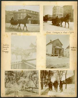
Arthur and Fred Landen photograph album – page 30
Page 30 of a photograph album created by brothers Arthur and Fred Landen of Hull, England. Page consists of 6 photographs taken by Fred Landen depicting, clockwise from top-left: A horse-drawn “speeder” sleigh in front of the Nares Building on Main Street and Lombard Avenue; a horse-drawn toboggan in front of the old post office on Main Street and McDermot Avenue; a workman’s house; children standing in winter clothes in a residential neighbourhood; Fred Landen sitting in wooded area, “The Grove” in “Kildonia” [Kildonan] - likely Fraser's Grove in East Kildonan; and a horse and buggy in a residential neighbourhood.
Landen, Frederick Cluett

Aerial of 1974 Flood – Red River between North and West Kildonan
Aerial photograph of the Red River during the 1974 Flood. The photograph faces west from North Kildonan, where the Chief Peguis Trail now stands, across the river towards Kildonan Park and West Kildonan on the left, the North End Water Treatment Plant in the middle, and Old Kildonan on the right. The photographs were taken by the Department of Environmental Planning.
Winnipeg (Man.). Department of Environmental Planning

William Smaill Photo Album – Page 9
Part of William Smaill fonds
Captions read: Station men's shack - Boggy number 1 - Hadashville - Settlers' house - Whitemouth - camp 3 - Indian Bay, April 1914.
Smaill, William

William Smaill Photo Album – Page 13
Part of William Smaill fonds
Captions read: Jackfish - Whitemouth - Trail, Indian Bay - Whitemouth - Birch River - Whitemouth - McLerie's.
Smaill, William
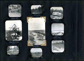
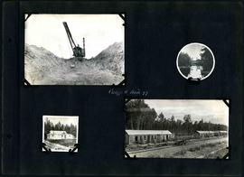
William Smaill Photo Album – Page 29
Part of William Smaill fonds
Captions read: Engineer's camp, Birch River, mile 77 - Sailman's camp, mile 88 - Hospital, mile 77 - Bay City dredge, mile 89 - Pilot ditch, mile 89 - Dyke, Indian Bay - Engineer's camp, mile 88 - Tremblays camp 1 - Mile 85.5, '16.
Smaill, William

William Smaill Photo Album – Page 56
Part of William Smaill fonds
Captions read: Richan's house and ours at Whitemouth.
Smaill, William
William Smaill Photo Album – Page 60
Part of William Smaill fonds
Captions read: Camp 5, mile 77.
Smaill, William

Preliminary Report on Residential Areas - Metropolitan Plan for Greater Winnipeg
Part of City Clerk's Library collection
Item consists of 1 report (60 pages), jointly prepared by the Metropolitan Planning Committee and Winnipeg Town Planning Commission. The report focuses on residential areas in the Greater Winnipeg Area. Part of the Metropolitan Plan for Greater Winnipeg - number 7 of master plan reports.
Manitoba. Metropolitan Planning Commission of Greater Winnipeg

Part of City of Winnipeg (1874-1971)
A photograph of flooding on Disraeli St during the 1950 flood. The photograph shows a child standing on a pile of lumber beside the flooded street.
Harold K. White Studio
Part of City of Winnipeg (1874-1971)
Item is part of small album containing photographs of maps tracking the outbreak of typhoid from 1905 to 1908 and other scenes. Item is loose and at back of album. Date of item is approximate, [circa 1909].