

Apartment block at 415 Edison Avenue
- i04658
- Pièce
- [197-?]
Fait partie de City of Winnipeg Archives Photograph collection
Apartment block at 415 Edison Avenue, near Rothesay Street.
54 résultats avec objets numériques Afficher les résultats avec des objets numériques
Apartment block at 415 Edison Avenue
Fait partie de City of Winnipeg Archives Photograph collection
Apartment block at 415 Edison Avenue, near Rothesay Street.

Aerial of 1974 Flood – Red River between East and West Kildonan
Fait partie de City of Winnipeg Archives Photograph collection
Aerial photograph of the Red River during the 1974 Flood. The photograph faces northwest from around Helmsdale Avenue and Kildonan Drive in East Kildonan towards Scotia Street in the Seven Oaks area of West Kildonan across the river. The photographs were taken by the Department of Environmental Planning.
Sans titre

Aerial of 1974 Flood – Pritchard Avenue Boat Dock and Redwood Bridge
Fait partie de City of Winnipeg Archives Photograph collection
Aerial photograph of the Red River during the 1974 Flood. The photograph faces northwest towards the North End, with the Pritchard Avenue Boat Dock in the bottom left and the Redwood Bridge in the top right. The photographs were taken by the Department of Environmental Planning.
Sans titre

Aerial of 1974 Flood – Fraser’s Grove Park
Fait partie de City of Winnipeg Archives Photograph collection
Aerial photograph of the Red River during the 1974 Flood. The photograph faces southwest from Fraser’s Grove Park and Kildonan Drive in East Kildonan towards Scotia Street in the Seven Oaks area of West Kildonan. The photographs were taken by the Department of Environmental Planning.
Sans titre

Aerial of 1974 Flood – Bergen Cutoff Bridge
Fait partie de City of Winnipeg Archives Photograph collection
Aerial photograph of the Bergen Cutoff Bridge during the 1974 Flood. The photograph faces northwest from Kildonan Drive in North Kildonan across the Red River towards Kildonan Park and Old Kildonan. The photographs were taken by the Department of Environmental Planning.
Sans titre

Aerial of 1974 Flood – Red River between North and West Kildonan
Fait partie de City of Winnipeg Archives Photograph collection
Aerial photograph of the Red River during the 1974 Flood. The photograph faces west from North Kildonan, where the Chief Peguis Trail now stands, across the river towards Kildonan Park and West Kildonan on the left, the North End Water Treatment Plant in the middle, and Old Kildonan on the right. The photographs were taken by the Department of Environmental Planning.
Sans titre
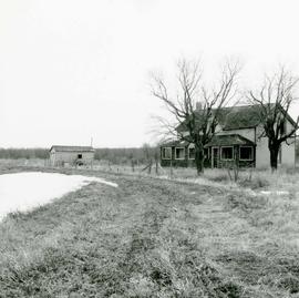
Area of John Blumberg Golf Course prior to construction.
Fait partie de Metropolitan Corporation of Greater Winnipeg
Photograph of abandoned buildings on a rural stretch of land in the area of what is now John Blumberg Golf Course. A description of the photo used for publication is recorded on a separate piece of paper. Photo's reverse is stamped by the Parks and Protection Division of the Metro Government.
Sans titre

Wildwood Park - Three weeks before flood, 1950
Fait partie de City of Winnipeg Archives Photograph collection

Wildwood Park - Three weeks before flood, 1950
Fait partie de City of Winnipeg Archives Photograph collection
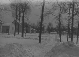
Wildwood Park - Three weeks before flood, 1950
Fait partie de City of Winnipeg Archives Photograph collection

Sandbags on the dyke (Wildwood Park - flood, 1950)
Fait partie de City of Winnipeg Archives Photograph collection
![Sandbags - E sec [section] (Wildwood Park - flood, 1950)](/uploads/r/city-of-winnipeg-archives-amp-records-control-branch/c/4/a/c4a7e5ee657f2cf565da1e983d41beae65af0b67f4b9fb5fa71c540b99003de4/C0013_0000_0000_P0022_0094_001_142.jpg)
Sandbags - E sec [section] (Wildwood Park - flood, 1950)
Fait partie de City of Winnipeg Archives Photograph collection
Fait partie de City of Winnipeg Archives Photograph collection
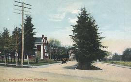
Postcard includes message from Tab to Beat? on verso. Published by C. S. Co. Ltd., Winnipeg, printed in Saxony.

Preliminary Report on Residential Areas - Metropolitan Plan for Greater Winnipeg
Fait partie de City Clerk's Library collection
Item consists of 1 report (60 pages), jointly prepared by the Metropolitan Planning Committee and Winnipeg Town Planning Commission. The report focuses on residential areas in the Greater Winnipeg Area. Part of the Metropolitan Plan for Greater Winnipeg - number 7 of master plan reports.
Sans titre
Fait partie de Parks and Recreation Photograph collection
Four photographs affixed two to each side of a page of construction paper. The two photos on the first side depict children playing at the Scotia Rink, while those on the second depict children on a swing set and eating ice cream.
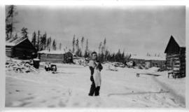
Log cabins at city wood camp, Greater Winnipeg Water District Railway
Fait partie de City of Winnipeg Archives Photograph collection
Photograph shows man standing in front of log cabins used by workers at wood cutting camps. Date of photograph is approximate, ca. 1930.
Fait partie de Parks and Recreation Photograph collection
An album page with a photograph on each side. The photographs depict a Parks Board supervised skating rink outside the Northland Knitting Company at 618 Arlington Street on each side.
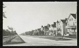
Fait partie de Morris Block collection
Photograph of houses on Edmonton Street, likely south of Portage Avenue.
Sans titre
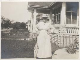
Mother in front of 49 Balmoral Place
Fait partie de City of Winnipeg Archives Photograph collection
Date of photograph is approximate, ca. 1918.
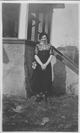
Neta Turner in front of house in Fort Garry, Winnipeg
Fait partie de City of Winnipeg Archives Photograph collection
Date of photograph is approximate, ca. 1918.