

Main Street, south of Seven Oaks, 48 hours after rain
- i01416
- Item
- 1932
Date of photograph is July 8, 1932.
Main Street, south of Seven Oaks, 48 hours after rain
Date of photograph is July 8, 1932.

Photograph shows old St. James Bridge approach, looking North up present Kintrye Street. Viscount Gort site centre right/Hydro sub-station - St. James Street and Portage Avenue far left. Date of photograph is uncertain [after 1932].

1950 Flood - Flood Evacuees at the St. Boniface train station
A Short, Pictorial Documentary on the Winnipeg Flood of 1950
Portigal & Wardle
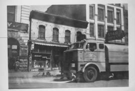
Sicard Flusher, Market Street - May 1948
Star Hotel, Market Café, Dirkfield's Novelty Mfg. shown in background of photograph.

Automobile Drive, from Royal Alexandra, Winnipeg
Date of postcard is uncertain, [before 1949].
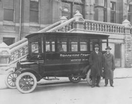
Date of photograph is approximate, ca. 1920.
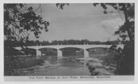
The Foot Bridge in City Park, Winnipeg, Manitoba
Photograph shows the foot bridge across the Assiniboine River in City Park. Date of photograph is approximate, ca. 1940.
![C.P.R. Yards looking West [Aerial view]](/uploads/r/city-of-winnipeg-archives-amp-records-control-branch/1/d/2/1d24b0471a50903dd76276838a7e169e4890a17020a9cfe6a0d34e153ebb9ec9/C0013_0000_0000_P0018_0027_001_142.jpg)
C.P.R. Yards looking West [Aerial view]
Inscription (on recto): WG A114 30-2-42 CPR [Canadian Pacific Railway] RR [Railroad] Yards looking West.
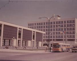
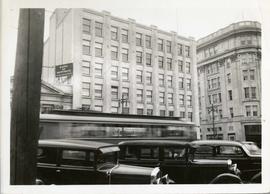
A photograph of the Civic Centre Complex, Winnipeg's third city hall (1964-present). Council Building, Administration Building, and public transit bus in view. Taken from William Avenue and Main Street, looking northwest. Date of photograph is uncertain, [197-?]. The photographer is likely Henry Kalen.
Kalen, Henry
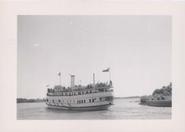
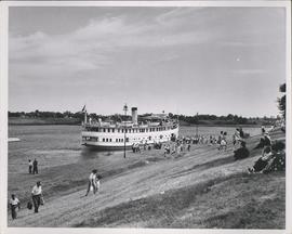
S.S. Keenora with crowds of people on deck
Stamp (on verso): Taylor Made Service Process, July 11 ????. Date of photograph is uncertain, [192-?].

Visit of Duke and Duchess of Cornwall & York (George V and Queen Mary)
Photograph showing an arch built near the C.P.R. Station in honour of a visit by the Duke and Duchess of Cornwall & York, George V and Queen Mary.

The Cove Restaurant, corner of Portage and Carlton
Photograph of "The Cove" Restaurant at 355 Portage Avenue, at Carlton Street. The photograph was taken from a building on Carlton Street looking southeast towards the Eaton's Building, Mitchell-Copp, Zeller's, and the Carlton Building.
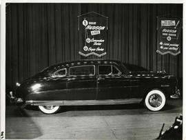
A Hudson brand car on display at a car show likely held in the Civic Auditorium on Vaughan Street. Banners advertiseing the Commodre and Super Series cars hang above.
Storefronts in the Power Building
A view of cars and shoppers outside the Power Building at the corner of Portage Avenue and Vaughan Street. Street level storefronts include the Winnipeg Electric Company showroom and Rexall / Liggett's drug store. Above are the offices of Western Empire L
Power Building and Hudson's Bay Company Building
View of the North side of the corner of Portage Avenue and Vaughan Street, featuring the Power Building and Hudson's Bay Company Building. I front are parked cars and a street car passing by.

Southdale Shopping Centre panorama
View of Southdale Shopping Centre, 35 Lakewood Boulevard, 12.8 acres. From left to right: Dominion Store, Canadian Imperial Bank of Commerce, Mall Entrance, Quintons, Ebbeling Pharmacy, Kmart Department Store. Consists of 3 separate photographs pasted together on cardboard to create a panorama. The cardboard is a scrap made from an old sign of the Metropolitan Corporation of Greater Winnipeg (visible on the reverse). The cardboard is numbered “5”, presumably as part of a compilation with other shopping centre panoramas.
Metropolitan Corporation of Greater Winnipeg (Man.). Planning Division

Polo Park Shopping Centre panorama
View of Polo Park Shopping Centre, 1485 Portage Avenue, 41 acres. South side of shopping centre. Left to right: Winnipeg Motor Products, Motor Club, Simpson Sears Service Station, Simpson Sears Department Store. Consists of 3 separate photographs pasted together on cardboard to create a panorama. The cardboard is a scrap made from an old sign of the Metropolitan Corporation of Greater Winnipeg (visible on the reverse). The cardboard is numbered “13”, presumably as part of a compilation with other shopping centre panoramas.
Metropolitan Corporation of Greater Winnipeg (Man.). Planning Division

Arthur and Fred Landen photograph album – page 28
Page 28 of a photograph album created by brothers Arthur and Fred Landen of Hull, England. Page consists of 6 photographs taken by Fred Landen depicting, clockwise from top-left: bricklayers in front of houses; women on a horse-drawn sleigh (captioned “Cutter”); police in raccoon-skin uniforms; a streetcar crossing the Osborne Bridge; a Ox-drawn sleigh in front of the Royal Oak Hotel in Market Square (Market Avenue and King Street); and a woman pushing a baby in a sleigh in at the northwest corner of Broadway and Kennedy Street.
Landen, Frederick Cluett
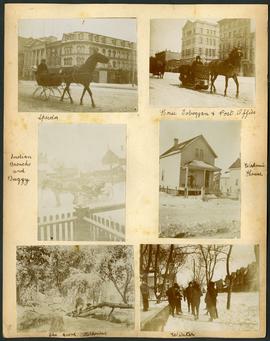
Arthur and Fred Landen photograph album – page 30
Page 30 of a photograph album created by brothers Arthur and Fred Landen of Hull, England. Page consists of 6 photographs taken by Fred Landen depicting, clockwise from top-left: A horse-drawn “speeder” sleigh in front of the Nares Building on Main Street and Lombard Avenue; a horse-drawn toboggan in front of the old post office on Main Street and McDermot Avenue; a workman’s house; children standing in winter clothes in a residential neighbourhood; Fred Landen sitting in wooded area, “The Grove” in “Kildonia” [Kildonan] - likely Fraser's Grove in East Kildonan; and a horse and buggy in a residential neighbourhood.
Landen, Frederick Cluett