
![Logan Avenue and Salter Street [Aerial view]](/uploads/r/city-of-winnipeg-archives-amp-records-control-branch/9/8/0/980f8ba4214d821c9b49366ae35d9ea9ed5b7f44366c5cd894e04befdd6c7a22/C0013_0000_0000_P0018_0033_001_142.jpg)
Logan Avenue and Salter Street [Aerial view]
- i01918
- Pièce
- 1943
Fait partie de City of Winnipeg Archives Photograph collection
Inscription (on recto): A161 3-9-43 Logan Ave and Salter St Wp [Winnipeg?] about 4000' 5".
68 résultats avec objets numériques Afficher les résultats avec des objets numériques
Logan Avenue and Salter Street [Aerial view]
Fait partie de City of Winnipeg Archives Photograph collection
Inscription (on recto): A161 3-9-43 Logan Ave and Salter St Wp [Winnipeg?] about 4000' 5".
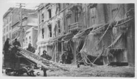
The "Blue Store," Main Street, Winnipeg after fire - January 25, 1918
Fait partie de City of Winnipeg Archives Photograph collection
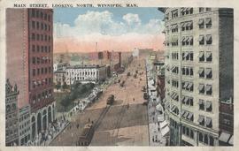
Main Street, looking north, Winnipeg, Man.
Fait partie de City of Winnipeg Archives Photograph collection
Postcard showing Main Street looking north from Bannatyne Avenue. Date of postcard is unknown.

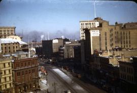
Corner Portage Avenue and Main Street, Winnipeg, Manitoba
Fait partie de City of Winnipeg Archives Photograph collection
Print is a photographic image of the intersection of Portage Avenue and Main Street. Date of print is uncertain, [193-].
Fait partie de City of Winnipeg Archives Photograph collection

The Cove Restaurant, corner of Portage and Carlton
Fait partie de City of Winnipeg Archives Photograph collection
Photograph of "The Cove" Restaurant at 355 Portage Avenue, at Carlton Street. The photograph was taken from a building on Carlton Street looking southeast towards the Eaton's Building, Mitchell-Copp, Zeller's, and the Carlton Building.

Main Street looking northeast to Grace Methodist Church
Fait partie de City of Winnipeg Archives Photograph collection
Photograph of a muddy Main Street in 1871, facing northeast from around St. Mary Avenue. Featured on the photograph's right-hand side is Grace Methodist Church, located at Main Street and Water Avenue (now William Stephenson Way), which was opened on September 17 of that year.

Waghorn's Guide map and street index
Fait partie de City Clerk's Library collection
Waghorn's Guide - a small promotional pamphlet published by J.R. Waghorn in 1895. The pamphlet contains a street map of Winnipeg, a street index, and advertisements for various Winnipeg businesses including the Clarendon Hotel, the Redwood Brewery, and the Massey-Harris Company. The map shows the old City of Winnipeg from the Red River on the east to Waverly, Aubrey, and McPhillips Streets on the west, and from Athole Avenue (now Luxton Avenue) in the north to Parker Avenue in the south. Southern Elmwood, Old St. Boniface, and Norwood are also shown on the east side of the river. Railway lines are in black and electric street railway lines are in red.