
- i00536
- Item
- 1950
Part of City of Winnipeg (1874-1971)
A photograph taken during the 1950 flood, showing 77 Luxton Avenue and 79 Luxton Avenue and 81 Luxton Avenue. Item is 8 of 8 photographs on page 49 of scrapbook.
Harold K. White Studio
42 results with digital objects Show results with digital objects
Part of City of Winnipeg (1874-1971)
A photograph taken during the 1950 flood, showing 77 Luxton Avenue and 79 Luxton Avenue and 81 Luxton Avenue. Item is 8 of 8 photographs on page 49 of scrapbook.
Harold K. White Studio
Part of City of Winnipeg (1874-1971)
A photograph taken during the 1950 flood, showing 42 Luxton Avenue and 44 Luxton Avenue and 46 Luxton Avenue. Item is 2 of 6 photographs on page 50 of scrapbook.
Harold K. White Studio
62, 64 and 66 Lansdowne Avenue
Part of City of Winnipeg (1874-1971)
A photograph taken during the 1950 flood, showing 62 Lansdowne Avenue and 64 Lansdowne Avenue and 66 Lansdowne Avenue. Item is 7 of 8 photographs on page 51 of scrapbook.
Harold K. White Studio
70, 72, 74, 76 and 78 Lansdowne Avenue
Part of City of Winnipeg (1874-1971)
A photograph taken during the 1950 flood, showing 70 Lansdowne Avenue and 72 Lansdowne Avenue and 74 Lansdowne Avenue and 76 Lansdowne Avenue and 78 Lansdowne Avenue. Item is 8 of 8 photographs on page 51 of scrapbook.
Harold K. White Studio
81, 83, 85 and 87 Lansdowne Avenue
Part of City of Winnipeg (1874-1971)
A photograph taken during the 1950 flood, showing 81 Lansdowne Avenue and 83 Lansdowne Avenue and 85 Lansdowne Avenue and 87 Lansdowne Avenue. Item is 8 of 8 photographs on page 52 of scrapbook.
Harold K. White Studio
43, 45, 47 and 49 Polson Avenue
Part of City of Winnipeg (1874-1971)
A photograph taken during the 1950 flood, showing 43 Polson Avenue and 45 Polson Avenue and 47 Polson Avenue and 49 Polson Avenue. Item is 4 of 8 photographs on page 53 of scrapbook.
Harold K. White Studio
Part of City of Winnipeg (1874-1971)
A photograph taken during the 1950 flood, showing 69 Polson Avenue and 75 Polson Avenue and 81 Polson Avenue. Item is 7 of 8 photographs on page 53 of scrapbook.
Harold K. White Studio
Part of City of Winnipeg (1874-1971)
A photograph taken during the 1950 flood, showing 34 Polson Avenue and 38 Polson Avenue. Item is 1 of 5 photographs on page 54 of scrapbook.
Harold K. White Studio
62, 64, 66, 68, 70 and 72 Polson Avenue
Part of City of Winnipeg (1874-1971)
A photograph taken during the 1950 flood, showing 62 Polson Avenue and 64 Polson Avenue and 66 Polson Avenue and 68 Polson Avenue and 70 Polson Avenue. Item is 3 of 5 photographs on page 54 of scrapbook.
Harold K. White Studio
78, 80, 84, 86 and 88 Polson Avenue
Part of City of Winnipeg (1874-1971)
A photograph taken during the 1950 flood, showing 78 Polson Avenue and 80 Polson Avenue and 84 Polson Avenue and 86 Polson Avenue and 88 Polson Avenue. Item is 5 of 5 photographs on page 54 of scrapbook.
Harold K. White Studio
Part of City of Winnipeg (1874-1971)
A photograph taken during the 1950 flood, showing 43 Barber Street and 45 Barber Street. Item is 2 of 8 photographs on page 57 of scrapbook.
Harold K. White Studio
Part of City of Winnipeg (1874-1971)
A photograph taken during the 1950 flood, showing 47 Barber Street and 49 Barber Street. Item is 3 of 8 photographs on page 57 of scrapbook.
Harold K. White Studio
Part of City of Winnipeg (1874-1971)
A photograph taken during the 1950 flood, showing 71 Barber Street and 73 Barber Street and 75 Barber Street. Item is 7 of 8 photographs on page 57 of scrapbook.
Harold K. White Studio
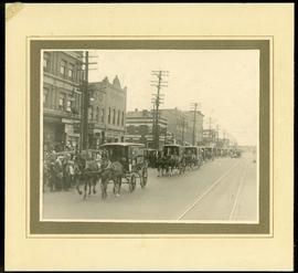
Canada Bread delivery wagons at Main and Selkirk
Part of Morris Block collection
Photograph mounted on cardboard of a cavalcade of Canada Bread horse-drawn delivery wagons riding south down Main Street, at the corner of Selkirk Avenue.
Block, Morris

Crane and David, Bakers and Confectioners
Staff standing in front of Crane and David Bakers and Confectioners at 765 Dufferin Avenue and a horse-drawn delivery cart.
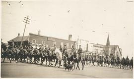
Photograph shows Lord Strathcona Horse, just before departure overseas during World War 1, at Selkirk and Main, looking at the east side of Main Street..

1932 Relief Works and Committee Winnipeg
Photograph collage of the 1932 Winnipeg Relief Works and Committee. Portraits of committee members are surrounding photographs of projects the committee had worked on. The committee members are, clockwise from top left: Alderman John Blumberg, Alderman H. Andrews, City Clerk Magnus Peterson, Alderman J.A. Barry, Alderman A.A. Ryley, Alderman W.B. Simpson, City Engineer W.P. Brereton, G.W. Northwood, Alderman E.D. Honeyman, Mayor Ralph Webb, Alderman J.A. McKerschar, A. MacNamara, Resident Engineer A.J. Taunton, Alderman L.F. Borrowman, and Alderman C.E. Simonite. The works projects showcased in the center are, clockwise from top left: the Main Street Bridge, the Norwood Bridge, the Assiniboine Park Bridge, the Winnipeg Auditorium, the Sargent Park Swimming Pool, and the Salter Street Bridge. Created by Robson Photo.

Aerial of 1974 Flood – Pritchard Avenue Boat Dock and Redwood Bridge
Aerial photograph of the Red River during the 1974 Flood. The photograph faces northwest towards the North End, with the Pritchard Avenue Boat Dock in the bottom left and the Redwood Bridge in the top right. The photographs were taken by the Department of Environmental Planning.
Winnipeg (Man.). Department of Environmental Planning
![Logan Avenue and Main Street [Aerial view]](/uploads/r/city-of-winnipeg-archives-amp-records-control-branch/d/9/2/d92728eee72f0ac3b14bbb8ea8f04c5d3ece08f19538ee5d078eb79492de602b/C0013_0000_0000_P0018_0034_001_142.jpg)
Logan Avenue and Main Street [Aerial view]
Inscription (on recto): A160 3-9-43 Logan Ave and Main St Wpg [Winnipeg] about 4000' 5".
![Vicinity of Elmwood Park [Aerial view]](/uploads/r/city-of-winnipeg-archives-amp-records-control-branch/5/b/9/5b929d618c2f619e557788462eee14587693511e7959bc6ca77ae96654d1bc98/C0013_0000_0000_P0018_0041_001_142.jpg)
Vicinity of Elmwood Park [Aerial view]
Inscription (on recto): WG M35: 3-15, 5 Mar '45, vicinity Elmwood Park Wpg, appr. scale 1/12000.