

- i00122
- Pièce
- May 15, 1950
Fait partie de City of Winnipeg (1874-1971)
A photograph of Higgins Avenue during the 1950 flood. A bridge over the swollen Red River can also be seen.
Sans titre
Fait partie de City of Winnipeg (1874-1971)
A photograph of Higgins Avenue during the 1950 flood. A bridge over the swollen Red River can also be seen.
Sans titre

Fait partie de City of Winnipeg (1874-1971)
Photograph shows the North End Farmer's Market (west side Main Street, north of Stella Avenue, looking west to King Street). Included in photograph: front entrance to market, automobiles parked on street, and North End Horse Exchange (523 King Street). Photograph likely taken from 919-921 Main Street by city employee.

Fait partie de City of Winnipeg (1874-1971)
Photograph of the Winnipeg Renovating Co. and the Grain Exchange on Lombard Avenue. Item is part of small album containing photographs of maps tracking the outbreak of typhoid from 1905 to 1908 and other scenes. Item is loose and at back of album. Date of item is approximate, [circa 1909].

Fait partie de City of Winnipeg (1874-1971)
Photograph of the Winnipeg Renovating Co. on Lombard Avenue. Item is part of small album containing photographs of maps tracking the outbreak of typhoid from 1905 to 1908 and other scenes. Item is loose and at back of album. Date of item is approximate, [circa 1909].

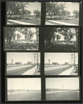
Mini-park on Academy Road at Kenaston Boulevard
Fait partie de Metropolitan Corporation of Greater Winnipeg
Photograph of a small park at the intersection of Academy Road and Kenaston Boulevard after Metro's beautification efforts, featuring trees, benches, and a water feature. A description of the photo used for publication is recorded on a separate piece of paper. Photo's reverse is stamped by the Parks and Protection Division of the Metro Government.
Sans titre
Scenes from around St. James and the St. James Bridge
Fait partie de Metropolitan Corporation of Greater Winnipeg
Consists of several photos of the area around the St. James Bridge and includes small parks and green spaces, and the St. James Shopping Centre on Portage Avenue near Moray Street. Photographer is unknown.
Sans titre
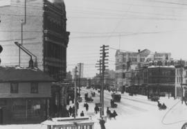
Winnipeg Street Railway on Portage Avenue in front of Merchants Hotel
Fait partie de City of Winnipeg Archives Photograph collection

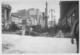
Main Street, south of Seven Oaks, 48 hours after rain
Fait partie de City of Winnipeg Archives Photograph collection
Date of photograph is July 8, 1932.
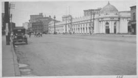
Industrial Bureau Exposition Building
Fait partie de City of Winnipeg Archives Photograph collection
Photograph shows the Industrial Bureau Exposition Building, also called the Board of Trade Building, at Main Street and Water Avenue (now William Stephenson Way). Date of photograph is approximate, ca. 1915.
View of Notre Dame Avenue looking east from Kate Street
Fait partie de City of Winnipeg Archives Photograph collection
Photograph shows Notre Dame Avenue looking east from Kate Street toward Lindsay Building at 228 Notre Dame Avenue. Businesses appearing in photograph include Green Orchard Lunch, 551 Notre Dame Avenue, and B - A Service Station. Date of photograph is approximate, ca. 1939.
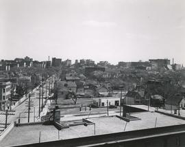
View of Main Street looking north from the Western Canada Loan Building
Fait partie de City of Winnipeg Archives Photograph collection
Photograph shows view of Main Street looking north from the roof of the Western Canada Loan Building, 392 Main Street at Portage Avenue. Date of photograph is approximate, ca. 1935.

Fait partie de City of Winnipeg Archives Photograph collection
Photograph shows old St. James Bridge approach, looking North up present Kintrye Street. Viscount Gort site centre right/Hydro sub-station - St. James Street and Portage Avenue far left. Date of photograph is uncertain [after 1932].

Overhanging Signs: North side of Portage Avenue looking East from Langside Street
Fait partie de City of Winnipeg Archives Photograph collection
Photograph shows signs for multiple businesses, including Club Morocco and Aqua-Terre Pet & Sporting Goods. Date of photograph is uncertain, [196-?].

Overhanging Signs: North side of Portage Avenue
Fait partie de City of Winnipeg Archives Photograph collection
Photograph shows sign for Club Morocco. Date of photograph is uncertain, [196-?].

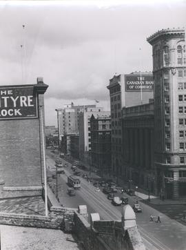
Main Street Winnipeg looking south from City Hall
Fait partie de City of Winnipeg Archives Photograph collection
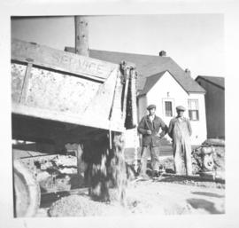
Dump truck unloading concrete for screeds on Inkster Boulevard, east of McKenzie Street
Fait partie de City of Winnipeg Archives Photograph collection
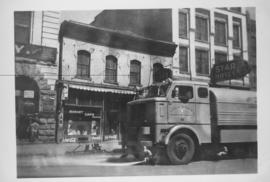
Sicard Flusher, Market Street - May 1948
Fait partie de City of Winnipeg Archives Photograph collection
Star Hotel, Market Café, Dirkfield's Novelty Mfg. shown in background of photograph.
Fait partie de City of Winnipeg Archives Photograph collection
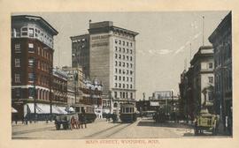
Postcard shows Main Street looking north from McDermot Avenue to Union Bank Building. Date of postcard is uncertain, [before 1949].