

- i00151
- Pièce
- 1950
Fait partie de City of Winnipeg (1874-1971)
A photograph, taken from the north, of a flooded underpass on Anabella Street during the 1950 flood in Winnipeg. Some people in a boat are travelling down the street.
Sans titre
355 résultats avec objets numériques Afficher les résultats avec des objets numériques
Fait partie de City of Winnipeg (1874-1971)
A photograph, taken from the north, of a flooded underpass on Anabella Street during the 1950 flood in Winnipeg. Some people in a boat are travelling down the street.
Sans titre
Fait partie de City of Winnipeg (1874-1971)
A photograph of a flooded underpass on Anabella Street during the 1950 flood in Winnipeg.
Sans titre
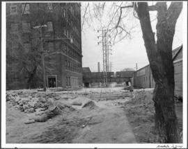
Fait partie de City of Winnipeg (1874-1971)
A photograph of a causeway near an underpass on Anabella Street during the 1950 flood in Winnipeg. A city employee is driving some equipment down the causeway.
Sans titre

Fait partie de City of Winnipeg (1874-1971)
A photograph of the Rover Street hydro station, surrounded by water, during the 1950 flood.
Sans titre

Fait partie de City of Winnipeg (1874-1971)
A photograph of the Rover Street hydro station, surrounded by water, during the 1950 flood. A group of people are walking on the sandbag dike that surrounds the building.
Sans titre

Fait partie de City of Winnipeg (1874-1971)
A photograph of the Rover Street hydro station, surrounded by water, during the 1950 flood.
Sans titre

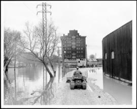
Fait partie de City of Winnipeg (1874-1971)
A photograph of high water surrounding a causeway that ran to the Rover Street hydro station during the 1950 flood.
Sans titre

Foot of Robert Street (Galt Ave)
Fait partie de City of Winnipeg (1874-1971)
A photograph of the Eaton's printing plant and warehouse on Robert Street (Galt Avenue) during the 1950 flood. The building is surrounded by a sandbag dike and water.
Sans titre

Fait partie de City of Winnipeg (1874-1971)
A photograph of high water surrounding a power house during the 1950 flood.
Sans titre

Building Water Street causeway about 2nd day
Fait partie de City of Winnipeg (1874-1971)
A photograph of the building of the Water Street causeway during the 1950 flood in Winnipeg. St. Boniface Cathedral can be seen in the background.
Sans titre
Dyking built up around Shaarey Zedek Synagogue, 1950 Flood
Fait partie de City of Winnipeg Archives Photograph collection
Photograph taken at Shaarey Zedek Synagogue, 561 Wellington Crescent off Academy Road, on the western bank of the Assiniboine River. - Stamp (on verso): by Harold K. White Studio, 274 Fort St. Winnipeg, Phone 924 289.
Sans titre

Aerial of 1974 Flood – Pritchard Avenue Boat Dock and Redwood Bridge
Fait partie de City of Winnipeg Archives Photograph collection
Aerial photograph of the Red River during the 1974 Flood. The photograph faces northwest towards the North End, with the Pritchard Avenue Boat Dock in the bottom left and the Redwood Bridge in the top right. The photographs were taken by the Department of Environmental Planning.
Sans titre

Aerial of 1974 Flood – Fraser’s Grove Park
Fait partie de City of Winnipeg Archives Photograph collection
Aerial photograph of the Red River during the 1974 Flood. The photograph faces southwest from Fraser’s Grove Park and Kildonan Drive in East Kildonan towards Scotia Street in the Seven Oaks area of West Kildonan. The photographs were taken by the Department of Environmental Planning.
Sans titre

Aerial of 1974 Flood – Red River between East and West Kildonan
Fait partie de City of Winnipeg Archives Photograph collection
Aerial photograph of the Red River during the 1974 Flood. The photograph faces northwest from around Helmsdale Avenue and Kildonan Drive in East Kildonan towards Scotia Street in the Seven Oaks area of West Kildonan across the river. The photographs were taken by the Department of Environmental Planning.
Sans titre

Aerial of 1974 Flood – Bergen Cutoff Bridge
Fait partie de City of Winnipeg Archives Photograph collection
Aerial photograph of the Bergen Cutoff Bridge during the 1974 Flood. The photograph faces northwest from Kildonan Drive in North Kildonan across the Red River towards Kildonan Park and Old Kildonan. The photographs were taken by the Department of Environmental Planning.
Sans titre

Aerial of 1974 Flood – Red River between North and West Kildonan
Fait partie de City of Winnipeg Archives Photograph collection
Aerial photograph of the Red River during the 1974 Flood. The photograph faces west from North Kildonan, where the Chief Peguis Trail now stands, across the river towards Kildonan Park and West Kildonan on the left, the North End Water Treatment Plant in the middle, and Old Kildonan on the right. The photographs were taken by the Department of Environmental Planning.
Sans titre

Colony Street and Whitehall Avenue
Fait partie de City of Winnipeg Archives Photograph collection
Photograph is one of five photos mounted on page with caption "Assiniboine River flooded, Spring 1916."

Foot of Water Street, C.N.R. Bridge - the Flood
Fait partie de City of Winnipeg Archives Photograph collection
Photograph is one of five photos mounted on page with caption "Assiniboine River flooded, Spring 1916."

Fait partie de City of Winnipeg Archives Photograph collection
Photograph is one of five photos mounted on page with caption "Assiniboine River flooded, Spring 1916."

Fait partie de City of Winnipeg Archives Photograph collection
Photograph is one of five photos mounted on page with caption "Assiniboine River flooded, Spring 1916."