

- i00151
- Pièce
- 1950
Fait partie de City of Winnipeg (1874-1971)
A photograph, taken from the north, of a flooded underpass on Anabella Street during the 1950 flood in Winnipeg. Some people in a boat are travelling down the street.
Sans titre
355 résultats avec objets numériques Afficher les résultats avec des objets numériques
Fait partie de City of Winnipeg (1874-1971)
A photograph, taken from the north, of a flooded underpass on Anabella Street during the 1950 flood in Winnipeg. Some people in a boat are travelling down the street.
Sans titre
Fait partie de City of Winnipeg (1874-1971)
A photograph of a flooded underpass on Anabella Street during the 1950 flood in Winnipeg.
Sans titre
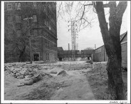
Fait partie de City of Winnipeg (1874-1971)
A photograph of a causeway near an underpass on Anabella Street during the 1950 flood in Winnipeg. A city employee is driving some equipment down the causeway.
Sans titre
25, 27, 27-1/2 and 29 Inkster Boulevard
Fait partie de City of Winnipeg (1874-1971)
A photograph taken during the 1950 flood, showing 25 Inkster Boulevard and 27 Inkster Boulevard and 27 1/2 Inkster Boulevard and 29 Inkster Boulevard. Item is 2 of 8 photographs on page 32 of scrapbook.
Sans titre

Fait partie de City of Winnipeg (1874-1971)
A photograph of the Rover Street hydro station, surrounded by water, during the 1950 flood.
Sans titre

Fait partie de City of Winnipeg (1874-1971)
A photograph of the Rover Street hydro station, surrounded by water, during the 1950 flood. A group of people are walking on the sandbag dike that surrounds the building.
Sans titre

Fait partie de City of Winnipeg (1874-1971)
A photograph of the Rover Street hydro station, surrounded by water, during the 1950 flood.
Sans titre

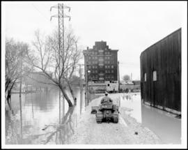
Fait partie de City of Winnipeg (1874-1971)
A photograph of high water surrounding a causeway that ran to the Rover Street hydro station during the 1950 flood.
Sans titre

Foot of Robert Street (Galt Ave)
Fait partie de City of Winnipeg (1874-1971)
A photograph of the Eaton's printing plant and warehouse on Robert Street (Galt Avenue) during the 1950 flood. The building is surrounded by a sandbag dike and water.
Sans titre

Fait partie de City of Winnipeg (1874-1971)
A photograph of high water surrounding a power house during the 1950 flood.
Sans titre
Fait partie de City of Winnipeg (1874-1971)
A photograph taken during the 1950 flood, showing 105 River Avenue. Item is 8 of 8 photographs on page 87 of scrapbook.
Fait partie de City of Winnipeg (1874-1971)
A photograph taken during the 1950 flood, showing 128 River Avenue. Item is 6 of 8 photographs on page 87 of scrapbook.
Fait partie de City of Winnipeg (1874-1971)
A photograph taken during the 1950 flood, showing 9 Blanchard. Item is 2 of 2 photographs on page 111 of scrapbook.
Sans titre
Fait partie de City of Winnipeg (1874-1971)
A photograph taken during the 1950 flood, showing 115 Westgate. Item is 1 of 2 photographs on page 109 of scrapbook.
Sans titre
Fait partie de City of Winnipeg (1874-1971)
A photograph taken during the 1950 flood, showing 115 Westgate. Item is 2 of 2 photographs on page 109 of scrapbook.
Sans titre
Fait partie de City of Winnipeg (1874-1971)
A photograph taken during the 1950 flood, showing looking south on Eastgate. Item is 1 of 2 photographs on page 110 of scrapbook.
Sans titre
Fait partie de City of Winnipeg (1874-1971)
A photograph taken during the 1950 flood, showing 115 Westgate and 119 Westgate and 131 Westgate. Item is 1 of 2 photographs on page 110 of scrapbook.
Sans titre
Fait partie de City of Winnipeg (1874-1971)
A photograph taken during the 1950 flood, showing 137 Westgate. Item is 2 of 2 photographs on page 110 of scrapbook.
Sans titre
Fait partie de City of Winnipeg (1874-1971)
A photograph taken during the 1950 flood, showing 64 Middlegate. Item is 2 of 2 photographs on page 103 of scrapbook.
Sans titre
Fait partie de City of Winnipeg (1874-1971)
A photograph taken during the 1950 flood, showing 94 Middlegate. Item is 1 of 2 photographs on page 104 of scrapbook.
Sans titre