
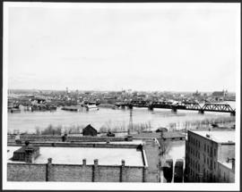
Flooding on the Red River towards St. Boniface.
- i00144
- Pièce
- 1950
Fait partie de City of Winnipeg (1874-1971)
A photograph of the flooded Red River during the 1950 flood in Winnipeg. The photograph is taken looking toward St. Boniface.
Sans titre
70 résultats avec objets numériques Afficher les résultats avec des objets numériques
Flooding on the Red River towards St. Boniface.
Fait partie de City of Winnipeg (1874-1971)
A photograph of the flooded Red River during the 1950 flood in Winnipeg. The photograph is taken looking toward St. Boniface.
Sans titre
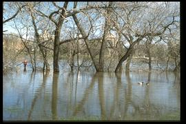
1997 flood - The Forks - view of St. Boniface across river
Fait partie de Winnipeg Flood Record and Archives Committee collection
A photograph of St. Boniface Cathedral, taken from across the flooded Red River during the 1997 flood.
Sans titre

Fait partie de City of Winnipeg (1874-1971)

Part of East Ward, St. Boniface in the distance
Fait partie de City of Winnipeg (1874-1971)
Photograph taken from top of Courthouse.
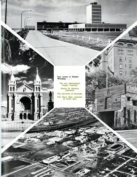
Four scenes in Greater Winnipeg
Fait partie de Metropolitan Corporation of Greater Winnipeg
Photograph shows the then new International Airport Terminal, the St. Boniface Cathedral prior to the 1968 fire, the University of Manitoba and the Fort Garry Gate.
Sans titre

Waghorn's Guide map and street index
Fait partie de City Clerk's Library collection
Waghorn's Guide - a small promotional pamphlet published by J.R. Waghorn in 1895. The pamphlet contains a street map of Winnipeg, a street index, and advertisements for various Winnipeg businesses including the Clarendon Hotel, the Redwood Brewery, and the Massey-Harris Company. The map shows the old City of Winnipeg from the Red River on the east to Waverly, Aubrey, and McPhillips Streets on the west, and from Athole Avenue (now Luxton Avenue) in the north to Parker Avenue in the south. Southern Elmwood, Old St. Boniface, and Norwood are also shown on the east side of the river. Railway lines are in black and electric street railway lines are in red.

View looking west over Red River into downtown Winnipeg from St. Boniface
Fait partie de City of Winnipeg Archives Photograph collection
Photograph shows view of downtown Winnipeg, between Notre Dame Avenue East (Pioneer Avenue) and Lombard Avenue. Barge on the Red River also appears in photograph. Date of photograph is approximate, ca. 1930.

Floods - St. Boniface and Norwood - April 1916
Fait partie de City of Winnipeg Archives Photograph collection
Postcard is a photographic print showing water flooding homes. Photograph taken by Advance Photo Company, Winnipeg. Azo mark appears in stamp box, made in Canada.

Rue Langevin, Floods, St. Boniface - April 1916
Fait partie de City of Winnipeg Archives Photograph collection
Postcard is a photographic print showing flood water and debris around buildings. Photograph taken by Advance Photo Company, Winnipeg. Azo mark appears in stamp box, made in Canada.

Winnipeg Boat Club under water, Norwood, April 1916
Fait partie de City of Winnipeg Archives Photograph collection
Postcard is a photographic print. Photograph taken by Advance Photo Company, Winnipeg. Azo mark appears in stamp box, made in Canada.
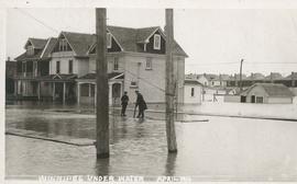
Winnipeg under water - April 1916
Fait partie de City of Winnipeg Archives Photograph collection
Postcard is a photographic print showing water flooding homes likely in St. Boniface. Unknown photographer, Noko mark appears in stamp box.
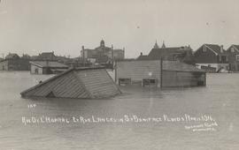
Rue De L'Hopital et Rue Langevin, St. Boniface Floods, April 1916
Fait partie de City of Winnipeg Archives Photograph collection
Postcard is a photographic print showing water flooding homes and other structures. Photograph taken by Advance Photo Company, Winnipeg. Azo mark appears in stamp box, made in Canada.

No. 8 A portion of the Lyndale dike in Norwood with the Norwood Bridge in the background
Fait partie de City of Winnipeg Archives Photograph collection
Photograph shows scene from 1950 flood. Description (on verso): Note the roof of the Greater Winnipeg Sanitary District Marion Street pumping station on the right. Stamp (on verso): City of Winnipeg - Engineering Dept., Water Works Division, Ross and Tecumseh.

1950 Flood - Flood Evacuees at the St. Boniface train station
Fait partie de City of Winnipeg Archives Photograph collection
A Short, Pictorial Documentary on the Winnipeg Flood of 1950
Sans titre

St. Boniface Basilica and the Assumption Monument
Fait partie de City of Winnipeg Archives Photograph collection
Photograph shows St. Boniface Basilica in background. The Assumption (monument) commemorating the saving of St. Boniface from the 1950 flood shown in foreground.
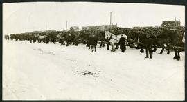
Unloading of relief wood at Greater Winnipeg Water District Station
Fait partie de City of Winnipeg Archives Photograph collection
Men at the Greater Winnipeg Water District station in St. Boniface standing in front of horses hauling wood piles for relief work. Photograph taken by Robinson Studio.

Rue Langevin, St. Boniface under water floods April 1916, showing men in boat
Fait partie de City of Winnipeg Archives Photograph collection
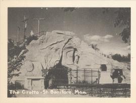
The Grotto, St. Boniface, Man.
Fait partie de City of Winnipeg Archives Photograph collection
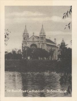
St. Boniface Cathedral, St. Boniface
Fait partie de City of Winnipeg Archives Photograph collection
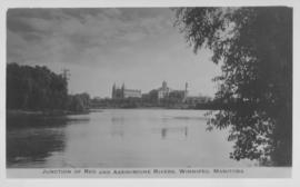
Junction of Red and Assiniboine Rivers, Winnipeg, Manitoba
Fait partie de City of Winnipeg Archives Photograph collection
Date of photograph is approximate, ca. 1940.