
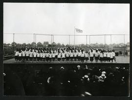
Girls on stage in Fort Rouge Park
- p00310
- Part
- [ca. 1930]
Photograph of a group of girls performing on a stage in front of an audience in Fort Rouge Park. Photograph is affixed to one side of an album page.
Girls on stage in Fort Rouge Park
Photograph of a group of girls performing on a stage in front of an audience in Fort Rouge Park. Photograph is affixed to one side of an album page.
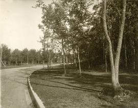
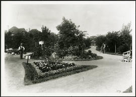
A view of a path in Crescentwood Park affixed to one side of an album page. Photographed by Steele and Company.

Scrapbook of Corporal Wallace – page 9
Page 9 of a photograph scrapbook made by Corporal John Wallace in April 1940. Photographs depict a street in Gladstone Manitoba, a trolley bus in Winnipeg on Kennedy Street (between Ellice and Qu'Appelle), and the Butler family, acquaintances of Wallace. See page three of this scrapbook for more details on the Butler family.
Wallace, John
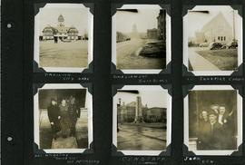
Scrapbook of Corporal Wallace – page 6
Page 6 of a photograph scrapbook made by Corporal John Wallace in April 1940. Photographs depict the Pavilion in City Park (Assiniboine Park), the Legislature Building off in the distance down Memorial Boulevard, St. Ignatius Church at Corydon Avenue and Stafford Street, the Winnipeg Cenotaph, and acquaintenances of Wallace, Mr. and Mrs. McCarthy and “Sister Sue”, and two people identified only as “Joan” and “Den”. See general notes section for more details.
Wallace, John
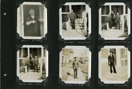
Scrapbook of Corporal Wallace – page 5
Page 5 of a photograph scrapbook made by Corporal John Wallace in April 1940. Photographs depict several acquaintenance of Wallace including two fellow soldiers, “Sonny” Robertson and Joseph “Fuss” McGrath, a Mrs. Penny, and a Frank Dowling and his family. See the general notes section for more details.
Wallace, John
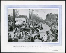
1939 Royal Procession at River and Osborne
Part of Morris Block collection
Photograph printed on cardboard of the corner of River Avenue and Osborne Street during the Royal Procession of Queen (then Princess) Elizabeth and King George on May 24, 1939.
Block, Morris

Waghorn's Guide map and street index
Part of City Clerk's Library collection
Waghorn's Guide - a small promotional pamphlet published by J.R. Waghorn in 1895. The pamphlet contains a street map of Winnipeg, a street index, and advertisements for various Winnipeg businesses including the Clarendon Hotel, the Redwood Brewery, and the Massey-Harris Company. The map shows the old City of Winnipeg from the Red River on the east to Waverly, Aubrey, and McPhillips Streets on the west, and from Athole Avenue (now Luxton Avenue) in the north to Parker Avenue in the south. Southern Elmwood, Old St. Boniface, and Norwood are also shown on the east side of the river. Railway lines are in black and electric street railway lines are in red.

Thoroughfares: Academy Road at Wellington Crescent
View of cars and cyclists heading down Academy Road towards Wellington Crescent and the Maryland Bridge. A small portion of Misericordia Hospital can be seen across the bridge.

Thoroughfares: Academy Road at Wellington Crescent
View of cars and cyclists heading down Academy Road towards Wellington Crescent and the Maryland Bridge. The cupola of Misericordia Hospital can be seen across the bridge.

Aerial view of Riverview, St. Vital, and Wildwood
Aerial view of the Riverview area of Fort Rouge, including Osborne Street; the Wildwood area of Fort Garry; and the Kingston Crescent, Elm Park, Varennes, St. George, and Glenlawn areas of St. Vital, including Kingston Row, St. Mary’s Road, and St. Anne’s Road.

Grant Plaza Shopping Centre panorama
View of Grant Park Plaza Shopping Centre, 1200-1216 Grant Avenue, 13.2 acres. From left to right: Clarks Discount Store, Dominion Store, Liquor Commission, Clarks Auto Centre. Consists of 3 separate photographs pasted together on cardboard to create a panorama. The cardboard is a scrap made from an old sign of the Metropolitan Corporation of Greater Winnipeg (visible on the reverse). The cardboard is numbered “8”, presumably as part of a compilation with other shopping centre panoramas.
Metropolitan Corporation of Greater Winnipeg (Man.). Planning Division
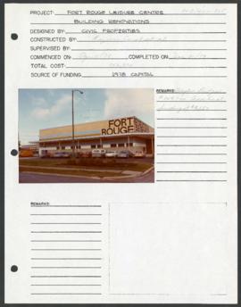
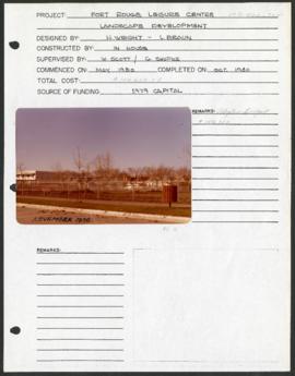
Fort Rouge Leisure Centre – project development components
Project development component form for the Fort Rouge Leisure Center with a colour photograph attached.
Winnipeg (Man.). Parks and Recreation Department
Fort Rouge Leisure Centre – project development components
Project development component form for the Fort Rouge Leisure Center with a colour photograph attached.
Winnipeg (Man.). Parks and Recreation Department
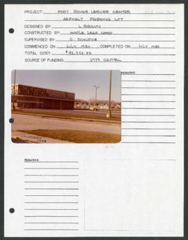
Fort Rouge Leisure Centre – project development components
Project development component form for the Fort Rouge Leisure Center with a colour photograph attached.
Winnipeg (Man.). Parks and Recreation Department
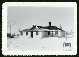
Winter photograph of the exterior of the Crescentwood Community Club.
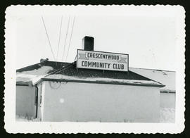
Winter photograph of the exterior of the Crescentwood Community Club.

Children's wading pool and park benches along a stone path in the Park.

Young trees planted in a grassy area intersected with stone paths. Caption: "Two Years Work".
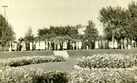
Photograph shows people gathered near a flower garden at Pembina Park (now known as Fisher Park). Date of photograph is 1938.