
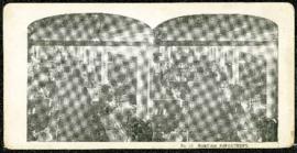
Eaton's promotional stereogram no. 17 - harness department
- i04487
- Item
- [ca. 1920]
Part of Morris Block collection
Block, Morris
144 results with digital objects Show results with digital objects
Eaton's promotional stereogram no. 17 - harness department
Part of Morris Block collection
Block, Morris
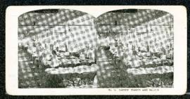
Eaton's promotional stereogram no. 15 - laidies’ waists and skirts
Part of Morris Block collection
Block, Morris
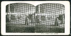
Eaton's promotional stereogram no. 11 - women’s suit section
Part of Morris Block collection
Block, Morris
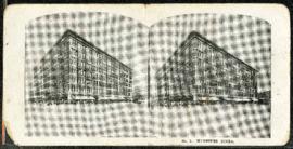
Eaton's promotional stereogram no. 1 - Winnipeg store
Part of Morris Block collection
Block, Morris

Photograph shows Eaton's storefront decorated with flags as part of the Victory in Europe Day (VE Day) celebrations that marked the end of World War II in Europe.
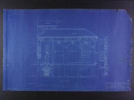
East elevation plans for the Club Building for the Columbus Hall Association
Part of City of Winnipeg (1874-1971)
Blueprint plans of east elevation of the Club Building for the Columbus Hall Association Ltd. on the southwest corner of Graham Avenue and Smith Street. Designed by John D. Atchison. Drawing 6 of 11.
Atchison, John D.

Earle Hill and His Cavemen at the Cave Supper Club
Part of Owen Clark collection
Photograph shows Claude Logan (piano), Sid Doe (bass), Earle Hill (violin, leader), Cy Dibnah (saxophone and vocals), Al Doe (drums), Gil Hansen (saxophone), Mickey Ryan (trumpet), Bus Totten (trumpet), Sharon Kane (vocalist).
Photograph shows Dufferin Avenue, east of the Arlington Bridge, in background. Date of photograph is approximate, ca. 1936.

Dakota Village Shopping Centre panorama
View of Dakota Village Shopping Centre, 1077-1095 St. Mary's Road, 3.5 acres. From left to right: unknown stores, Ladies and Children's Wear, Lance Pharmacy, [Dakota?] Bowling, Shoe Fair, Bank of Nova Scotia, Safeway, apartment block, Bank of Montreal. Consists of 3 separate photographs pasted together on cardboard to create a panorama. The cardboard is a scrap made from an old sign of the Metropolitan Corporation of Greater Winnipeg (visible on the reverse). The cardboard is numbered “6”, presumably as part of a compilation with other shopping centre panoramas.
Metropolitan Corporation of Greater Winnipeg (Man.). Planning Division

Crossroads Shopping Centre panorama
View of Crossroads Shopping Centre, 1580 Regent Avenue W., 18 acres. From left to right: Woolco Department Store, Various shops, Safeway, Pacific 66 Gas Bar. Consists of 3 separate photographs pasted together on cardboard to create a panorama. The cardboard is a scrap made from an old sign of the Metropolitan Corporation of Greater Winnipeg (visible on the reverse). The cardboard is numbered “3”, presumably as part of a compilation with other shopping centre panoramas.
Metropolitan Corporation of Greater Winnipeg (Man.). Planning Division

Crestview Shopping Centre panorama
View of Crestview Shopping Centre, 3395 Portage Avenue, 8.3 acres. From left to right: Kmart Department Store, Dominion Store, Various Shops. Consists of 3 separate photographs pasted together on cardboard to create a panorama. The cardboard is a scrap made from an old sign of the Metropolitan Corporation of Greater Winnipeg (visible on the reverse). The cardboard is numbered “9”, presumably as part of a compilation with other shopping centre panoramas.
Metropolitan Corporation of Greater Winnipeg (Man.). Planning Division

Crane and David, Bakers and Confectioners
Staff standing in front of Crane and David Bakers and Confectioners at 765 Dufferin Avenue and a horse-drawn delivery cart.

Crane and David (Western Cake and Pie Co) storefront
Part of Morris Block collection
Group photograph mounted on cardboard of the staff of Crane and David, Bakers and Confectioners (also knows as the Western Cake and Pie Company) in front of their store at 765 Dufferin Avenue.
Block, Morris

Corner Portage Avenue and Main Street, Winnipeg, Manitoba
Print is a photographic image of the intersection of Portage Avenue and Main Street. Date of print is uncertain, [193-].

Clark’s Department Store at Highway 59 panorama
View of Clarks at Highway 59, southwest corner of Panet Road and Nairn Avenue, 8.5 acres. From left to right: B/A gas bar, Loblaws, Clarks Discount Store and Auto Centre, B/A gas bar, Kavanaugh's Hamburgers. Consists of 3 separate photographs pasted together on cardboard to create a panorama. The cardboard is a scrap made from an old sign of the Metropolitan Corporation of Greater Winnipeg (visible on the reverse). The cardboard is numbered “4”, presumably as part of a compilation with other shopping centre panoramas.
Metropolitan Corporation of Greater Winnipeg (Man.). Planning Division

City Hall and Union Bank, Winnipeg
Postcard shows Winnipeg's second city hall (1886-1962) and Union Bank building.

City Hall and courtyard, facing Market Avenue
Photograph of the front side of Winnipeg's second City Hall, facing towards Market Avenue. Also featured in the photograph is the green space in front of City Hall, the Jubilee Fountain, the Volunteer Monument, businesses and store fronts on Market Avenue, and the McLaren and Cornwall Hotels in the distance. Photographed by Henry Kalen.
Metropolitan Corporation of Greater Winnipeg (Man.). Information Officer
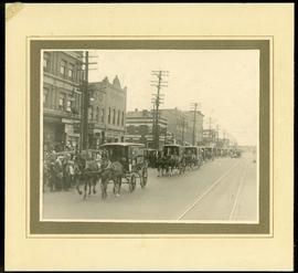
Canada Bread delivery wagons at Main and Selkirk
Part of Morris Block collection
Photograph mounted on cardboard of a cavalcade of Canada Bread horse-drawn delivery wagons riding south down Main Street, at the corner of Selkirk Avenue.
Block, Morris

Butcher's turnout in Market Square
Photograph of a large group, many on horseback, gathered for what the photograph's caption calls a "butcher's turnout" at the northwest corner of King Street and Market Avenue (the north side of Market Square). Photograph was taken by Israel Bennetto and has come apart into two pieces.
Bennetto, Israel
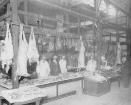
Butcher stall at public market
Item is a photographic reproduction, date unknown (original created 1884).