

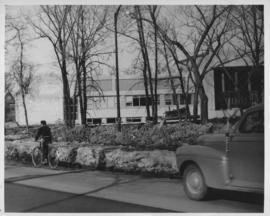
Wildwood Park - Three weeks before flood, 1950
- i02073
- Pièce
- 1950
Fait partie de City of Winnipeg Archives Photograph collection
355 résultats avec objets numériques Afficher les résultats avec des objets numériques
Wildwood Park - Three weeks before flood, 1950
Fait partie de City of Winnipeg Archives Photograph collection

No. 8 A portion of the Lyndale dike in Norwood with the Norwood Bridge in the background
Fait partie de City of Winnipeg Archives Photograph collection
Photograph shows scene from 1950 flood. Description (on verso): Note the roof of the Greater Winnipeg Sanitary District Marion Street pumping station on the right. Stamp (on verso): City of Winnipeg - Engineering Dept., Water Works Division, Ross and Tecumseh.
Dyking built up around Shaarey Zedek Synagogue, 1950 Flood
Fait partie de City of Winnipeg Archives Photograph collection
Photograph taken at Shaarey Zedek Synagogue, 561 Wellington Crescent off Academy Road, on the western bank of the Assiniboine River. - Stamp (on verso): by Harold K. White Studio, 274 Fort St. Winnipeg, Phone 924 289.
Sans titre

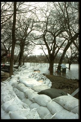
Wildwood Park - Three weeks before flood, 1950
Fait partie de City of Winnipeg Archives Photograph collection
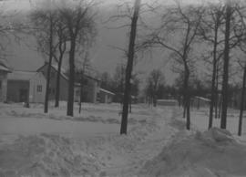
Wildwood Park - Three weeks before flood, 1950
Fait partie de City of Winnipeg Archives Photograph collection
Fait partie de City of Winnipeg Archives Photograph collection
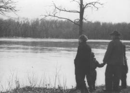
Photograph shows four people on riverbank looking out at high waters and flooded area in Wildwood Park during 1950 Flood.

Sandbags on the dyke (Wildwood Park - flood, 1950)
Fait partie de City of Winnipeg Archives Photograph collection

1950 Flood - Flood Evacuees at the St. Boniface train station
Fait partie de City of Winnipeg Archives Photograph collection
A Short, Pictorial Documentary on the Winnipeg Flood of 1950
Sans titre
![Sandbags - E sec [section] (Wildwood Park - flood, 1950)](/uploads/r/city-of-winnipeg-archives-amp-records-control-branch/c/4/a/c4a7e5ee657f2cf565da1e983d41beae65af0b67f4b9fb5fa71c540b99003de4/C0013_0000_0000_P0022_0094_001_142.jpg)
Sandbags - E sec [section] (Wildwood Park - flood, 1950)
Fait partie de City of Winnipeg Archives Photograph collection

Fait partie de City of Winnipeg (1874-1971)
A photograph of the Rover Street hydro station, surrounded by water, during the 1950 flood.
Sans titre

Fait partie de City of Winnipeg (1874-1971)
A photograph of the Rover Street hydro station, surrounded by water, during the 1950 flood. A group of people are walking on the sandbag dike that surrounds the building.
Sans titre

Aerial of 1974 Flood – Red River between East and West Kildonan
Fait partie de City of Winnipeg Archives Photograph collection
Aerial photograph of the Red River during the 1974 Flood. The photograph faces northwest from around Helmsdale Avenue and Kildonan Drive in East Kildonan towards Scotia Street in the Seven Oaks area of West Kildonan across the river. The photographs were taken by the Department of Environmental Planning.
Sans titre

Aerial of 1974 Flood – Pritchard Avenue Boat Dock and Redwood Bridge
Fait partie de City of Winnipeg Archives Photograph collection
Aerial photograph of the Red River during the 1974 Flood. The photograph faces northwest towards the North End, with the Pritchard Avenue Boat Dock in the bottom left and the Redwood Bridge in the top right. The photographs were taken by the Department of Environmental Planning.
Sans titre

Aerial of 1974 Flood – Fraser’s Grove Park
Fait partie de City of Winnipeg Archives Photograph collection
Aerial photograph of the Red River during the 1974 Flood. The photograph faces southwest from Fraser’s Grove Park and Kildonan Drive in East Kildonan towards Scotia Street in the Seven Oaks area of West Kildonan. The photographs were taken by the Department of Environmental Planning.
Sans titre

Aerial of 1974 Flood – Bergen Cutoff Bridge
Fait partie de City of Winnipeg Archives Photograph collection
Aerial photograph of the Bergen Cutoff Bridge during the 1974 Flood. The photograph faces northwest from Kildonan Drive in North Kildonan across the Red River towards Kildonan Park and Old Kildonan. The photographs were taken by the Department of Environmental Planning.
Sans titre

Aerial of 1974 Flood – Red River between North and West Kildonan
Fait partie de City of Winnipeg Archives Photograph collection
Aerial photograph of the Red River during the 1974 Flood. The photograph faces west from North Kildonan, where the Chief Peguis Trail now stands, across the river towards Kildonan Park and West Kildonan on the left, the North End Water Treatment Plant in the middle, and Old Kildonan on the right. The photographs were taken by the Department of Environmental Planning.
Sans titre

Fait partie de Winnipeg Flood Record and Archives Committee collection
A photograph of 201 Kingston Row during the 1997 flood.
Sans titre
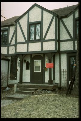
1997 flood - Kingston Row - house
Fait partie de Winnipeg Flood Record and Archives Committee collection
A photograph of a house on Kingston Row during the 1997 flood.
Sans titre

1997 flood - Kingston Crescent - sandbagging operations
Fait partie de Winnipeg Flood Record and Archives Committee collection
A photograph of a pile of sandbags in a playground on Kingston Crescent during the 1997 flood.
Sans titre
1997 flood - Elm Park Bridge and dike
Fait partie de Winnipeg Flood Record and Archives Committee collection
A photograph of a sandbag dike along the Red River close to the Elm Park Bridge during the 1997 flood.
Sans titre