

Winnipeg Street Railway on Portage Avenue in front of Merchants Hotel
- i01409
- Item
- [ca. 1886]
53 results with digital objects Show results with digital objects
Winnipeg Street Railway on Portage Avenue in front of Merchants Hotel
Cars and drivers, Clarendon Hotel
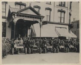
Photograph shows cars and drivers at Clarendon Hotel, northwest corner of Donald Street and Portage Avenue. - Inscription (on verso): 1st car, R. M. McLeod and R. Newman 2nd car, W. C. Power at wheel. 3rd car, Kelly Bros. 4th car, Douglas M. McLaughlin and Bert Wells (standing between cars is Ace Emmett). 5th car, Jack McCullock and Jimmy Boswell. - Date of photograph is approximate, ca. 1904.
Photographs of buildings on Portage Avenue including the Bank of Montreal, Zeller's, the Power Building, Winnipeg Electric Co. and the Royal Bank Building.

Westwood Shopping Centre panorama
View of Westwood Shopping Centre, 3276-3332 Portage Avenue, 10.2 acres. From left to right: various shops, motel, various shops and Assiniboia Public Library, Safeway Store, Marshall Wells, Perths, Westwood Pharmacy, various Shops, Zeller's County Fair, Auto Centre. Consists of 3 separate photographs pasted together on cardboard to create a panorama. The cardboard is a scrap made from an old sign of the Metropolitan Corporation of Greater Winnipeg (visible on the reverse). The cardboard is numbered “10”, presumably as part of a compilation with other shopping centre panoramas.
Metropolitan Corporation of Greater Winnipeg (Man.). Planning Division
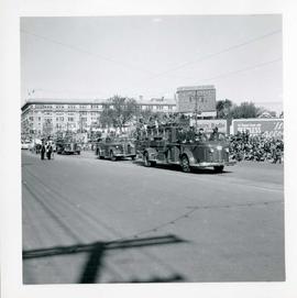
Winnipeg's 75th Anniversary parade - fire trucks
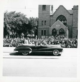
Winnipeg's 75th Anniversary parade - car carrying women


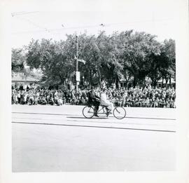
Winnipeg's 75th Anniversary parade - two person bicycle
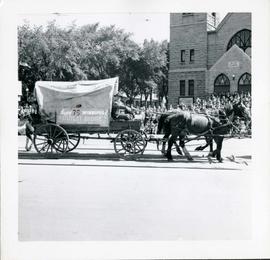
Winnipeg's 75th Anniversary parade - The Outlet Store float
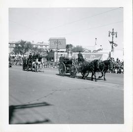
Winnipeg's 75th Anniversary parade - horse drawn fire engines

Main Street looking north from Portage Avenue
Part of City of Winnipeg (1874-1971)
Bentley Building, Courthouse and Artesian well shown in photograph.

A photograph of the Portage Avenue underpass, which crosses Century Street on the north side of the St. James Bridge. The photographer is unknown.
Metropolitan Corporation of Greater Winnipeg (Man.). Information Officer
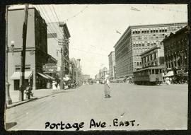
Portage looking east from around Carlton
Part of Morris Block collection
Photograph of a woman crossing Portage Avenue, looking east from around Carlton Street. The Eaton’s building can be seen on the right.
Block, Morris

Scrapbook of Corporal Wallace – page 2
Page 2 of a photograph scrapbook made by Corporal John Wallace in April 1940. Photos consist of Portage Avenue looking west from around Vaughn Street, a rail line at Portage Avenue and St. James Street, troops in formation, and Mrs. and Shirley Gardiner. See general notes section for more details.
Wallace, John

Winnipeg Electric Co. trolley bus
Photograph shows people waiting to board electric trolley bus (Winnipeg Electric Company), southbound Garry Street at Portage Avenue. Destination sign reads, No. 73 Sargent, Valour Road. Lindsay Building in background.

Storefronts on Portage Avenue between Carlton and Hargrave Streets
Cars and shoppers in front of stores on the north side of Portage Avenue, between Carlton and Hargrave Streets. Featured are The Berryhill Shoe Store in the Enderton / Mitchell-Copp Building, the Bank of Montreal, and Zeller's (Zellers).

Portage Avenue looking west from Colony Street
A view of Portage Avenue looking west from Colony Street. The Hudson's Bay Company Building is featured prominantly and the Power Building is visible farther west. Playing "Young Mr. Lincoln", the Gaiety Theatre can be seen across the street with two poli

Crestview Shopping Centre panorama
View of Crestview Shopping Centre, 3395 Portage Avenue, 8.3 acres. From left to right: Kmart Department Store, Dominion Store, Various Shops. Consists of 3 separate photographs pasted together on cardboard to create a panorama. The cardboard is a scrap made from an old sign of the Metropolitan Corporation of Greater Winnipeg (visible on the reverse). The cardboard is numbered “9”, presumably as part of a compilation with other shopping centre panoramas.
Metropolitan Corporation of Greater Winnipeg (Man.). Planning Division

Polo Park Shopping Centre panorama
View of Polo Park Shopping Centre, 1485 Portage Avenue, 41 acres. West side of shopping centre, north side of Portage Avenue between Empress Street and St. James Street. Left to Right: Winnipeg Stadium, Winnipeg Arena, Loblaws, Simpson Sears Marina, Simpson Sears Garden Shop, Simpson Sears Department Store, Simpson Sears Service Station. Consists of 4 separate photographs pasted together on cardboard to create a panorama. The cardboard is a scrap made from an old sign of the Metropolitan Corporation of Greater Winnipeg (visible on the reverse). The cardboard is numbered “11”, presumably as part of a compilation with other shopping centre panoramas.
Metropolitan Corporation of Greater Winnipeg (Man.). Planning Division