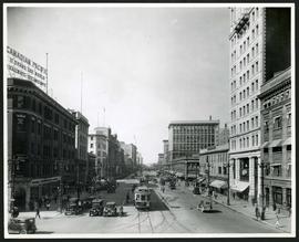
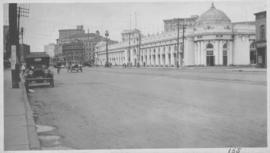
Affichage de 68 résultats

description archivistique
Winnipeg (Man.). Downtown Streets Avec objets numériques
Aperçu avant impression Hierarchy Affichage :

Pumping water on Robert Street

A photograph of a pipe pouring water onto tracks on Robert Street (Galt Avenue) during the 1950 flood. A pile of wood is along one side of the street. The Ogilvie Flour Mill can be seen in the background.

Sans titre

Winnipeg Renovating Co

Photograph of the Winnipeg Renovating Co. on Lombard Avenue. Item is part of small album containing photographs of maps tracking the outbreak of typhoid from 1905 to 1908 and other scenes. Item is loose and at back of album. Date of item is approximate, [circa 1909].

Winnipeg Renovating Co

Photograph of the Winnipeg Renovating Co. and the Grain Exchange on Lombard Avenue. Item is part of small album containing photographs of maps tracking the outbreak of typhoid from 1905 to 1908 and other scenes. Item is loose and at back of album. Date of item is approximate, [circa 1909].

North side of Lombard, Rorie to Main Street

A photograph of storefronts and advertisements on the north side of Lombard Avenue, between Rorie Street and Main Street. The photograph is part of small album containing photographs of maps tracking the outbreak of typhoid from 1905 to 1909 and other scenes. Item is loose and at back of album.

Waghorn's Guide map and street index

Waghorn's Guide - a small promotional pamphlet published by J.R. Waghorn in 1895. The pamphlet contains a street map of Winnipeg, a street index, and advertisements for various Winnipeg businesses including the Clarendon Hotel, the Redwood Brewery, and the Massey-Harris Company. The map shows the old City of Winnipeg from the Red River on the east to Waverly, Aubrey, and McPhillips Streets on the west, and from Athole Avenue (now Luxton Avenue) in the north to Parker Avenue in the south. Southern Elmwood, Old St. Boniface, and Norwood are also shown on the east side of the river. Railway lines are in black and electric street railway lines are in red.

Five street views

Page shows five street views of Winnipeg, ca. 1903: 1) Main Street from Commercial Club, 2) Elgin Avenue, 3) Geo. Velie, Wholesale Wines and Liquors, 4) William Avenue, looking west, and 5) Main Street, looking north from Portage Avenue.

Résultats 1 à 20 sur 68