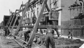
Contract 65 - Mile 3.2 - View of men mucking trench for 48 inch diameter Branch 1 aqueduct at Sta. 169+00 on Pacific Avenue. Looking west between Louise Street and Main Street. Work progressed westward from the west tunnel shaft. Buiilding of The James
Contract 65 - Mile 3.2 - View of men mucking trench for 48 inch diameter Branch 1 aqueduct at Sta. 169+00 on Pacific Avenue. Looking west between Louise Street and Main Street. Work progressed westward from the west tunnel shaft. Building of The James
Contract 65 - Mile 3.2 - View of men mucking trench for 48 inch diameter Branch 1 aqueduct at Sta. 169+00 on Pacific Avenue, looking west between Louise Street and Main Street. Work progressed westward from the west tunnel shaft. Building of The James R
Photograph of Portage Avenue looking west from the intersection at Main Street. Various shops and business are featured in buildings at Portage and Main that no longer exist, including the towering McArthur/Child's Building on the right. Photograph by Henry Kalen.
Metropolitan Corporation of Greater Winnipeg (Man.). Information Officer
Photograph of the front side of Winnipeg's second City Hall, facing towards Market Avenue. Also featured in the photograph is the green space in front of City Hall, the Jubilee Fountain, the Volunteer Monument, businesses and store fronts on Market Avenue, and the McLaren and Cornwall Hotels in the distance. Photographed by Henry Kalen.
Metropolitan Corporation of Greater Winnipeg (Man.). Information Officer
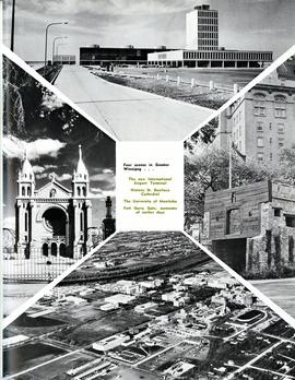
Photograph shows the then new International Airport Terminal, the St. Boniface Cathedral prior to the 1968 fire, the University of Manitoba and the Fort Garry Gate.
Metropolitan Corporation of Greater Winnipeg (Man.)
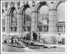
A photograph of the intersection of Broadway and Osborne Street during the 1950 flood in Winnipeg. The photo is taken from Osborne Street, looking north; the stone cross of All Saints' Church can be seen near the left side of the image.
A photograph of the Eaton's printing plant and warehouse on Robert Street (Galt Avenue) during the 1950 flood. The building is surrounded by a sandbag dike and water.
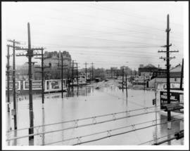
A photograph of a pipe pouring water onto tracks on Robert Street (Galt Avenue) during the 1950 flood. A pile of wood is along one side of the street. The Ogilvie Flour Mill can be seen in the background.