
- d00371
- File
- [after 1978]-[ca. 1990]
Photographs of and project development component forms for the Fort Rouge Leisure Centre.
28 results with digital objects Show results with digital objects
Photographs of and project development component forms for the Fort Rouge Leisure Centre.
Fort Rouge Leisure Centre – project development components
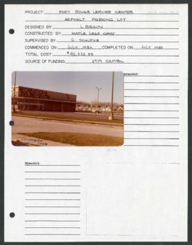
Project development component form for the Fort Rouge Leisure Center with a colour photograph attached.
Winnipeg (Man.). Parks and Recreation Department
Fort Rouge Leisure Centre – project development components
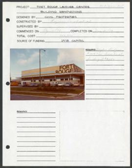
Project development component form for the Fort Rouge Leisure Center with a colour photograph attached.
Winnipeg (Man.). Parks and Recreation Department
Fort Rouge Leisure Centre – project development components
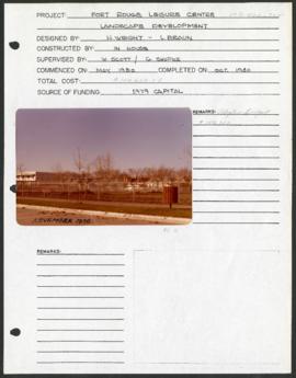
Project development component form for the Fort Rouge Leisure Center with a colour photograph attached.
Winnipeg (Man.). Parks and Recreation Department
Photographs of boulevards around Winnipeg, some new, others damaged.

Grant Plaza Shopping Centre panorama
View of Grant Park Plaza Shopping Centre, 1200-1216 Grant Avenue, 13.2 acres. From left to right: Clarks Discount Store, Dominion Store, Liquor Commission, Clarks Auto Centre. Consists of 3 separate photographs pasted together on cardboard to create a panorama. The cardboard is a scrap made from an old sign of the Metropolitan Corporation of Greater Winnipeg (visible on the reverse). The cardboard is numbered “8”, presumably as part of a compilation with other shopping centre panoramas.
Metropolitan Corporation of Greater Winnipeg (Man.). Planning Division

Part of Owen Clark collection
Group of musicians eating dinner at Don Carlos Casino with Johnny Bering standing in rear
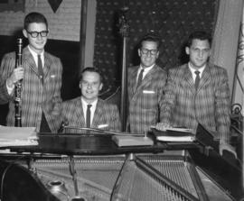
The Jose Poneira Quartet at The Rancho Don Carlos
Part of Owen Clark collection
Photograph shows the Jose Poneira Quartet at the Rancho Don Carlos. From left to right: Jimmy Weber, Jose Poneira, Jim Cordupel and Ed Sersen.
Scrapbook [1950 flood photographs]
Part of City of Winnipeg (1874-1971)
Subseries consists of a scrapbook assembled by the City Engineering Department to serve as photographic evidence of the 1950 flood. It contains black and white photographs that mostly document flooding in residential areas near the Red River (Fort Rouge, Riverview, North End, Point Douglas, Crescentwood, Armstrong's Point and others). Scrapbook appears to be organized geographically by area and street. In addition to documenting flooding, the photographs provide a detailed record of residential neighbourhoods, houses, streets, and businesses like corner grocery stores and laundries. All photographs were taken by Harold K. White Studio.
Winnipeg (Man.). City Engineer

Thoroughfares: Academy Road at Wellington Crescent
View of cars and cyclists heading down Academy Road towards Wellington Crescent and the Maryland Bridge. The cupola of Misericordia Hospital can be seen across the bridge.

Aerial view of Riverview, St. Vital, and Wildwood
Aerial view of the Riverview area of Fort Rouge, including Osborne Street; the Wildwood area of Fort Garry; and the Kingston Crescent, Elm Park, Varennes, St. George, and Glenlawn areas of St. Vital, including Kingston Row, St. Mary’s Road, and St. Anne’s Road.

Thoroughfares: Academy Road at Wellington Crescent
View of cars and cyclists heading down Academy Road towards Wellington Crescent and the Maryland Bridge. A small portion of Misericordia Hospital can be seen across the bridge.
Two photographs of the exterior of the Crescentwood Community Club in the winter.
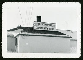
Winter photograph of the exterior of the Crescentwood Community Club.
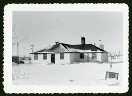
Winter photograph of the exterior of the Crescentwood Community Club.
![CNR Yards [Aerial view]](/uploads/r/city-of-winnipeg-archives-amp-records-control-branch/3/a/c/3acce1afab65125da800d4ce81f386345349a1e9b9021d949ebfd6c8147f2db0/C0013_0000_0000_P0018_0044_001_142.jpg)
Inscription (on recto): WG M35: 3-8, 5 Mar '45, CNR Yards Wpg, appr scale 1/12000.
![CNR Yards [Aerial view]](/uploads/r/city-of-winnipeg-archives-amp-records-control-branch/e/1/8/e184dce7e98d8a8fabf3b8481cfbdc63ba39898edb5f89746bd2e0a6795f8148/C0013_0000_0000_P0018_0045_001_142.jpg)
![Legislative Building and Central Winnipeg [Aerial view]](/uploads/r/city-of-winnipeg-archives-amp-records-control-branch/5/1/1/511af88a9e92fe7d7d3edda2bdaee6fc5652013532efb88411d3403dfcf85917/C0013_0000_0000_P0018_0046_001_142.jpg)
Legislative Building and Central Winnipeg [Aerial view]
Inscription (on recto): WG M35: 4-5, 5 Mar '45, Legislative Bldg and Central Wpg, appr. scale 1/12000.

Aerial photograph south of Winnipeg, east of Red River, 1943
Photograph shows an aerial view of south of Winnipeg, east of Red River. Photograph dated December 2, 1943.