

- i03951
- Item
- 1908
Young trees planted in a grassy area intersected with stone paths. Caption: "Two Years Work".
24 results with digital objects Show results with digital objects
Young trees planted in a grassy area intersected with stone paths. Caption: "Two Years Work".

Children's wading pool and park benches along a stone path in the Park.
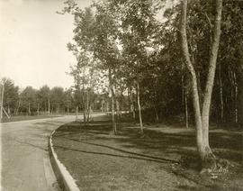
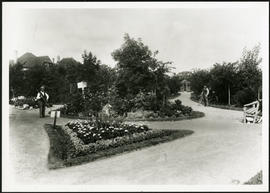
A view of a path in Crescentwood Park affixed to one side of an album page. Photographed by Steele and Company.
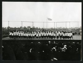
Girls on stage in Fort Rouge Park
Photograph of a group of girls performing on a stage in front of an audience in Fort Rouge Park. Photograph is affixed to one side of an album page.
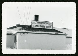
Winter photograph of the exterior of the Crescentwood Community Club.
Winter photograph of the exterior of the Crescentwood Community Club.
Part of City of Winnipeg (1874-1971)
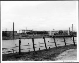
A photograph of a flooded underpass on Pembina Highway during the 1950 flood in Winnipeg.
Harold K. White Studio
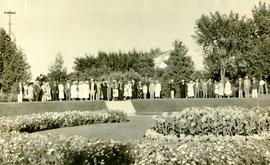
Photograph shows people gathered near a flower garden at Pembina Park (now known as Fisher Park). Date of photograph is 1938.
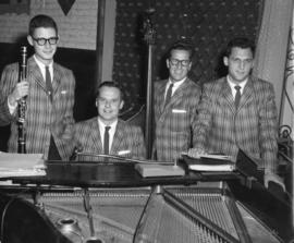
The Jose Poneira Quartet at The Rancho Don Carlos
Part of Owen Clark collection
Photograph shows the Jose Poneira Quartet at the Rancho Don Carlos. From left to right: Jimmy Weber, Jose Poneira, Jim Cordupel and Ed Sersen.
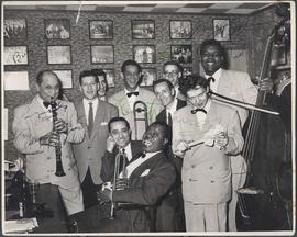
Louis Armstrong's Band at Rancho Don Carlos
Part of Owen Clark collection
Autographed photo of Louis Armstrong's band at Rancho Don Carlos. Photograph shows (L-R): Barney Bigard, George Reznick, Larry Schwartz, Trummy Young, Johnny Bering, Carl Riller, Kenny John, Arvel Shaw. (Seated, L-R): Charlie Mazzone, Louis Armstrong. Date of photograph is uncertain, taken in late 1940s.
![CNR Yards [Aerial view]](/uploads/r/city-of-winnipeg-archives-amp-records-control-branch/3/a/c/3acce1afab65125da800d4ce81f386345349a1e9b9021d949ebfd6c8147f2db0/C0013_0000_0000_P0018_0044_001_142.jpg)
Inscription (on recto): WG M35: 3-8, 5 Mar '45, CNR Yards Wpg, appr scale 1/12000.
![CNR Yards [Aerial view]](/uploads/r/city-of-winnipeg-archives-amp-records-control-branch/e/1/8/e184dce7e98d8a8fabf3b8481cfbdc63ba39898edb5f89746bd2e0a6795f8148/C0013_0000_0000_P0018_0045_001_142.jpg)
![Legislative Building and Central Winnipeg [Aerial view]](/uploads/r/city-of-winnipeg-archives-amp-records-control-branch/5/1/1/511af88a9e92fe7d7d3edda2bdaee6fc5652013532efb88411d3403dfcf85917/C0013_0000_0000_P0018_0046_001_142.jpg)
Legislative Building and Central Winnipeg [Aerial view]
Inscription (on recto): WG M35: 4-5, 5 Mar '45, Legislative Bldg and Central Wpg, appr. scale 1/12000.

Aerial photograph south of Winnipeg, east of Red River, 1943
Photograph shows an aerial view of south of Winnipeg, east of Red River. Photograph dated December 2, 1943.

Grant Plaza Shopping Centre panorama
View of Grant Park Plaza Shopping Centre, 1200-1216 Grant Avenue, 13.2 acres. From left to right: Clarks Discount Store, Dominion Store, Liquor Commission, Clarks Auto Centre. Consists of 3 separate photographs pasted together on cardboard to create a panorama. The cardboard is a scrap made from an old sign of the Metropolitan Corporation of Greater Winnipeg (visible on the reverse). The cardboard is numbered “8”, presumably as part of a compilation with other shopping centre panoramas.
Metropolitan Corporation of Greater Winnipeg (Man.). Planning Division

Thoroughfares: Academy Road at Wellington Crescent
View of cars and cyclists heading down Academy Road towards Wellington Crescent and the Maryland Bridge. The cupola of Misericordia Hospital can be seen across the bridge.

Thoroughfares: Academy Road at Wellington Crescent
View of cars and cyclists heading down Academy Road towards Wellington Crescent and the Maryland Bridge. A small portion of Misericordia Hospital can be seen across the bridge.
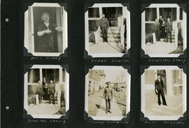
Scrapbook of Corporal Wallace – page 5
Page 5 of a photograph scrapbook made by Corporal John Wallace in April 1940. Photographs depict several acquaintenance of Wallace including two fellow soldiers, “Sonny” Robertson and Joseph “Fuss” McGrath, a Mrs. Penny, and a Frank Dowling and his family. See the general notes section for more details.
Wallace, John

Scrapbook of Corporal Wallace – page 9
Page 9 of a photograph scrapbook made by Corporal John Wallace in April 1940. Photographs depict a street in Gladstone Manitoba, a trolley bus in Winnipeg on Kennedy Street (between Ellice and Qu'Appelle), and the Butler family, acquaintances of Wallace. See page three of this scrapbook for more details on the Butler family.
Wallace, John