

- i00120
- Item
- May 15, 1950
Part of City of Winnipeg (1874-1971)
A photograph of flooding in a residential area of Winnipeg during the 1950 flood. The photograph was taken at the intersection of Disraeli and Euclid.
Harold K. White Studio
41 results with digital objects Show results with digital objects
Part of City of Winnipeg (1874-1971)
A photograph of flooding in a residential area of Winnipeg during the 1950 flood. The photograph was taken at the intersection of Disraeli and Euclid.
Harold K. White Studio

Part of City of Winnipeg (1874-1971)
A photograph of high water surrounding a causeway that ran to the Rover Street hydro station during the 1950 flood.
Harold K. White Studio
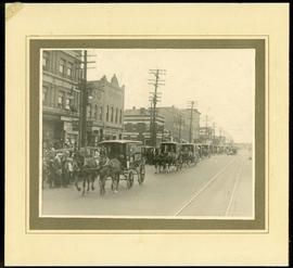
Canada Bread delivery wagons at Main and Selkirk
Part of Morris Block collection
Photograph mounted on cardboard of a cavalcade of Canada Bread horse-drawn delivery wagons riding south down Main Street, at the corner of Selkirk Avenue.
Block, Morris

Crane and David, Bakers and Confectioners
Staff standing in front of Crane and David Bakers and Confectioners at 765 Dufferin Avenue and a horse-drawn delivery cart.
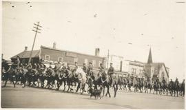
Photograph shows Lord Strathcona Horse, just before departure overseas during World War 1, at Selkirk and Main, looking at the east side of Main Street..

1932 Relief Works and Committee Winnipeg
Photograph collage of the 1932 Winnipeg Relief Works and Committee. Portraits of committee members are surrounding photographs of projects the committee had worked on. The committee members are, clockwise from top left: Alderman John Blumberg, Alderman H. Andrews, City Clerk Magnus Peterson, Alderman J.A. Barry, Alderman A.A. Ryley, Alderman W.B. Simpson, City Engineer W.P. Brereton, G.W. Northwood, Alderman E.D. Honeyman, Mayor Ralph Webb, Alderman J.A. McKerschar, A. MacNamara, Resident Engineer A.J. Taunton, Alderman L.F. Borrowman, and Alderman C.E. Simonite. The works projects showcased in the center are, clockwise from top left: the Main Street Bridge, the Norwood Bridge, the Assiniboine Park Bridge, the Winnipeg Auditorium, the Sargent Park Swimming Pool, and the Salter Street Bridge. Created by Robson Photo.

Aerial of 1974 Flood – Pritchard Avenue Boat Dock and Redwood Bridge
Aerial photograph of the Red River during the 1974 Flood. The photograph faces northwest towards the North End, with the Pritchard Avenue Boat Dock in the bottom left and the Redwood Bridge in the top right. The photographs were taken by the Department of Environmental Planning.
Winnipeg (Man.). Department of Environmental Planning
![Logan Avenue and Main Street [Aerial view]](/uploads/r/city-of-winnipeg-archives-amp-records-control-branch/d/9/2/d92728eee72f0ac3b14bbb8ea8f04c5d3ece08f19538ee5d078eb79492de602b/C0013_0000_0000_P0018_0034_001_142.jpg)
Logan Avenue and Main Street [Aerial view]
Inscription (on recto): A160 3-9-43 Logan Ave and Main St Wpg [Winnipeg] about 4000' 5".
![Vicinity of Elmwood Park [Aerial view]](/uploads/r/city-of-winnipeg-archives-amp-records-control-branch/5/b/9/5b929d618c2f619e557788462eee14587693511e7959bc6ca77ae96654d1bc98/C0013_0000_0000_P0018_0041_001_142.jpg)
Vicinity of Elmwood Park [Aerial view]
Inscription (on recto): WG M35: 3-15, 5 Mar '45, vicinity Elmwood Park Wpg, appr. scale 1/12000.

Sutherland Avenue at Brown & Rutherford building
Part of City of Winnipeg (1874-1971)
A photograph of earthen and sandbag dikes on Sutherland Avenue near the intersection of Brown and Rutherford during the 1950 flood in Winnipeg.
Harold K. White Studio

Beginning of Causeway Sutherland at Disraeli
Part of City of Winnipeg (1874-1971)
A photograph of equipment and vehicles at the beginning of a rock causeway at the intersection of Sutherland Avenue and Disraeli Street during the 1950 flood.
Harold K. White Studio

Part of City of Winnipeg (1874-1971)
A photograph of flooding on Disraeli St during the 1950 flood. The photograph shows a child standing on a pile of lumber beside the flooded street.
Harold K. White Studio

Part of City of Winnipeg (1874-1971)
A photograph of children on Higgins Avenue during the 1950 flood. Piles of earth and sandbags line the street.
Harold K. White Studio

Part of City of Winnipeg (1874-1971)
A photograph of a flooded underpass on Higgins Avenue during the 1950 flood.
Harold K. White Studio
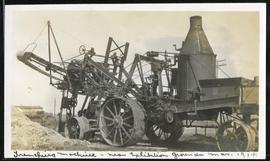
Trenching machine near Exhibition Grounds
Part of Morris Block collection
Block, Morris
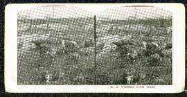
Eaton's promotional stereogram no. 12 - Winnipeg stock yards
Part of Morris Block collection
Block, Morris
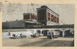
Subway, Main Street North, Winnipeg, Man.
Postcard shows C.P.R. Subway (Canadian Pacific Railway), looking south from Sutherland Avenue. Royal Alexandra Hotel and C.P.R. train sheds in view. Postmarked and note written on back. Date of postcard is uncertain, [before 1949].

Photograph album of Winnipeg during WW1: Page 5
Item consists of a scrapbook page showing soldiers lined up in military parade in front of the Industrial Bureau Exposition Building (Item 21), soldiers lined up in military parade (Item 22),
soldiers on horse in military parade in front of the Industrial Bureau Exposition Building (Item 23), crowd forming on street in front of the Israelite Jewish Daily newspaper building (975 Main Street) and the H. Lindster's Bakery (971 Main Street). Soldiers and Police in foreground (Item 24), [ca. 1913].
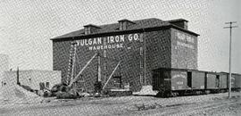
Photograph of the Vulcan Iron Works on page 152 of the Illustrated Souvenir of Winnipeg, published by W.M. Maretl and Sons, Half-Tone Engravers, in Winnipeg ca. 1903.

Arthur and Fred Landen photograph album – page 31
Page 31 of a photograph album created by brothers Arthur and Fred Landen of Hull, England. Page consists of 6 photographs taken by Fred Landen depicting, clockwise from top-left: shacks in residential area, likely the North End; men lighting a mosquito fire on the banks of the Red River; Fred Landen sitting on the bank of the Red River; a large house with brick veneer; a large house with wood veneer; and a horse-drawn sleigh advertising “A. Hendry. Grocer.” in front of a large house.
Landen, Frederick Cluett