
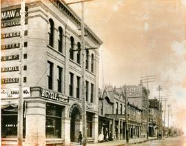
South West Corner of King and William
- i02346
- Item
- 1900
Item is a photographic reproduction, date unknown (original created ca. 1900). Shows the south west corner of King Street and William Avenue.
140 results with digital objects Show results with digital objects
South West Corner of King and William
Item is a photographic reproduction, date unknown (original created ca. 1900). Shows the south west corner of King Street and William Avenue.

Portage Avenue looking west from Colony Street
A view of Portage Avenue looking west from Colony Street. The Hudson's Bay Company Building is featured prominantly and the Power Building and the Boyd Building are visible farther west.

Portage Avenue looking west from Colony Street
A view of Portage Avenue looking west from Colony Street. The Hudson's Bay Company Building is featured prominantly and the Power Building is visible farther west. Playing "Young Mr. Lincoln", the Gaiety Theatre can be seen across the street with two poli

Thoroughfares: Academy Road at Wellington Crescent
View of cars and cyclists heading down Academy Road towards Wellington Crescent and the Maryland Bridge. The cupola of Misericordia Hospital can be seen across the bridge.

Thoroughfares: Academy Road at Wellington Crescent
View of cars and cyclists heading down Academy Road towards Wellington Crescent and the Maryland Bridge. A small portion of Misericordia Hospital can be seen across the bridge.

Scrapbook of Corporal Wallace – page 2
Page 2 of a photograph scrapbook made by Corporal John Wallace in April 1940. Photos consist of Portage Avenue looking west from around Vaughn Street, a rail line at Portage Avenue and St. James Street, troops in formation, and Mrs. and Shirley Gardiner. See general notes section for more details.
Wallace, John

Scrapbook of Corporal Wallace – page 9
Page 9 of a photograph scrapbook made by Corporal John Wallace in April 1940. Photographs depict a street in Gladstone Manitoba, a trolley bus in Winnipeg on Kennedy Street (between Ellice and Qu'Appelle), and the Butler family, acquaintances of Wallace. See page three of this scrapbook for more details on the Butler family.
Wallace, John
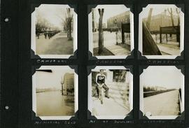
Scrapbook of Corporal Wallace – page 8
Page 8 of a photograph scrapbook made by Corporal John Wallace in April 1940. Photographs depict the Queen’s Own Cameron Highlanders of Canada near the Raleigh Apartments at Vaughan Street and Ellice Avenue, Memorial Boulevard (likely at Broadway, facing west with the Mall Hotel in the distance), a road outside Fort Osborne Barracks, and Corporal Wallace at the home of “The Dowlings” (likely on Beaverbrook Street).
Wallace, John
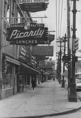
Overhanging Signs: North side of Portage Avenue looking East from Vaughan Street
Photograph shows signs for multiple businesses, including Picardy Lunches, Scientific Hairdressing, Credit Bureau. Date of photograph is uncertain, [196-?].

The Cove Restaurant, corner of Portage and Carlton
Photograph of "The Cove" Restaurant at 355 Portage Avenue, at Carlton Street. The photograph was taken from a building on Carlton Street looking southeast towards the Eaton's Building, Mitchell-Copp, Zeller's, and the Carlton Building.
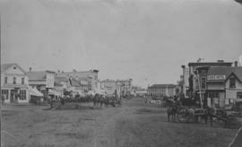
View of Main Street looking north
City of Winnipeg businesses shown in photograph: George Ashdown Hardware, Davis House, Symonds Furrier, Gable Hotel, J. Lister, Outfitter, Rossin House, the Blue Store, and the first City Hall is shown in background.
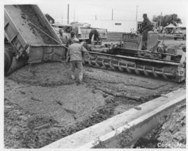
Item is part of series of photographs showing workmen, machinery and construction practices.
David Portigal and Company

For Your Guidance While in Winnipeg promotional map
Part of Morris Block collection
A promotional map created by the Publicity Bureau of Winnipeg and Manitoba titled "For Your Guidance While in Winnipeg". Map was originally folded as a pamphlet, the front page of which features a graphic of two people driving down Highway 14 (now Highway 75) to Winnipeg. The map is not scale and features cartoon depictions of tourist destinations and landmarks around Winnipeg and St. Boniface. The maps shows major streets, railroads, and street railway lines. The map side was originally framed and cut to fit. At a result a small part of the front page is cut off, including a stamp reading "St. Raphael's Ukrainian Immigrants' Welfare Association of Can[ada]".
Block, Morris

Overhanging Signs: North side of Portage Avenue
Photograph shows sign for Club Morocco. Date of photograph is uncertain, [196-?].

Overhanging Signs: North side of Portage Avenue looking East from Langside Street
Photograph shows signs for multiple businesses, including Club Morocco and Aqua-Terre Pet & Sporting Goods. Date of photograph is uncertain, [196-?].

Overhanging Signs: North side of Portage Avenue looking West from Young Street
Photograph shows signs for multiple businesses, including Club Morocco, Riviera Restaurant, Princeton Café Fish and Chips, Portage Credit Jewellers. Date of photograph is uncertain, [196-?].
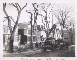
City crews trimming tree branches
Photograph shows city crews trimming tree branches.
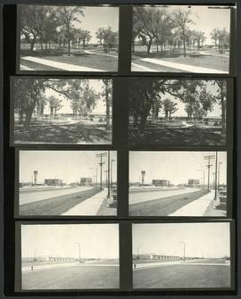
Scenes from around St. James and the St. James Bridge
Consists of several photos of the area around the St. James Bridge and includes small parks and green spaces, and the St. James Shopping Centre on Portage Avenue near Moray Street. Photographer is unknown.
Metropolitan Corporation of Greater Winnipeg (Man.). Information Officer

Main Street north of Portage Avenue
Photograph of a muddy Main Street in 1872, facing north from Portage Avenue and lined with shops on both sides, including a provisions store on the very right.

Main Street looking northeast to Grace Methodist Church
Photograph of a muddy Main Street in 1871, facing northeast from around St. Mary Avenue. Featured on the photograph's right-hand side is Grace Methodist Church, located at Main Street and Water Avenue (now William Stephenson Way), which was opened on September 17 of that year.