
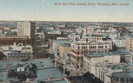
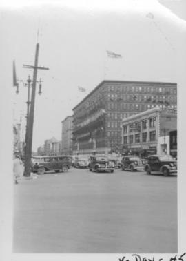
Bird's Eye View, looking North
- i01670
- Item
- 1910
Postcard shows view looking north, down Main Street from Lombard Avenue. Probably taken from roof of McArthur Building (Childs Building). Date of postcard is approximate, ca. 1910.
Bird's Eye View, looking North
Postcard shows view looking north, down Main Street from Lombard Avenue. Probably taken from roof of McArthur Building (Childs Building). Date of postcard is approximate, ca. 1910.
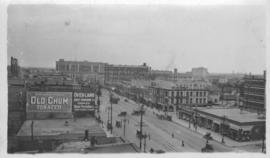
Photograph taken from McLaren Hotel at Rupert and Main Street, looking northeast, probably during World War 1. Date of photograph is uncertain, [between 1912 and 1925].
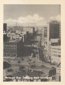
Portage Ave. looking east, Winnipeg
Photograph show Portage Avenue looking east from Main Street. Date of photograph is approximate, ca. 1940.
VE Day in Winnipeg showing Portage Avenue and Eaton's building in background
Photograph shows Victory in Europe Day (VE Day) celebrations marking the end of World War 2 in Europe.

Scrapbook of Corporal Wallace – page 9
Page 9 of a photograph scrapbook made by Corporal John Wallace in April 1940. Photographs depict a street in Gladstone Manitoba, a trolley bus in Winnipeg on Kennedy Street (between Ellice and Qu'Appelle), and the Butler family, acquaintances of Wallace. See page three of this scrapbook for more details on the Butler family.
Wallace, John
Portage Avenue and Main Street looking north

Portage Avenue looking west from Colony Street
A view of Portage Avenue looking west from Colony Street. The Hudson's Bay Company Building is featured prominantly and the Power Building and the Boyd Building are visible farther west.

Thoroughfares: Academy Road at Wellington Crescent
View of cars and cyclists heading down Academy Road towards Wellington Crescent and the Maryland Bridge. The cupola of Misericordia Hospital can be seen across the bridge.
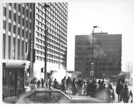
Caption (on file): "Shivering on the corner of Portage and Main on a cold, windy day waiting for traffic lights to change will now be just a memory with the opening of a climate controlled underground pedestrian concourse linking the four corners of Winnipeg's famous intersection."
Allan, Hugh
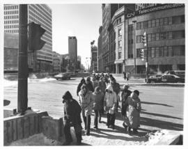

Aerial view of intersection at Portage Avenue and Main Street
Photograph shows aerial view of intersection at Portage Avenue and Main Street (after barriers closing intersection to pedestrian concourse). Also shows Bank of Nova Scotia (Trizec Building) under construction. Photograph likely taken from the top of the Richardson Building.
Allan, Hugh
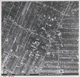
Aerial view of Vicinity of General Hospital, 1944
Description (on recto): WG A156, vicinity of General Hospital, Winnipeg, 1944. - Area around William Avenue and Sherbrook Street shown in photograph. - Photo credit: Royal Canadian Air Force Photograph.
![Logan Avenue and Main Street [Aerial view]](/uploads/r/city-of-winnipeg-archives-amp-records-control-branch/d/9/2/d92728eee72f0ac3b14bbb8ea8f04c5d3ece08f19538ee5d078eb79492de602b/C0013_0000_0000_P0018_0034_001_142.jpg)
Logan Avenue and Main Street [Aerial view]
Inscription (on recto): A160 3-9-43 Logan Ave and Main St Wpg [Winnipeg] about 4000' 5".

Colony Street and Whitehall Avenue
Photograph is one of five photos mounted on page with caption "Assiniboine River flooded, Spring 1916."
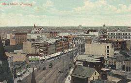
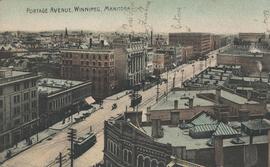
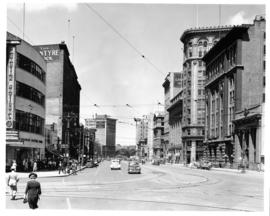
Postcard shows a view of Main Street from Portage Avenue looking north. Published by Valentine & Sons' Publishing Co., Ltd. Montreal and Toronto. Printed in Great Britain. Date of postcard is uncertain.