
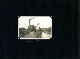
West Clarifier, pile foundation - clay core
- i01562
- Item
- [ca. 1940]
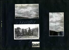
Photograph shows construction of sewer. Date of photograph is unknown.
185 results with digital objects Show results with digital objects
West Clarifier, pile foundation - clay core
Photograph shows construction of sewer. Date of photograph is unknown.
Fonds consists of a photo album created by William Smaill, Superintendent of the Winnipeg Aqueduct Construction Company, Ltd. The album contains photographs of the aqueduct’s construction, company men and their families, recreation, camps and homes used during construction, the Greater Winnipeg Water District Railway, and the surrounding landscape (Shoal Lake, Whitemouth River, Indian Bay, Birch River). There are also several photos of Winnipeg during Decoration Day 1914, photos of Mayors T.R. Deacon, Thomas Sharpe, and R.D. Waugh, and two photos of an Anishinaabe camp at Kekekoziibii Shoal Lake 40 First Nation.
The photos are heavily annotated. The annotations consist of names, locations, descriptions, and sometimes the section or specific mile of the aqueduct. A few photos appear to be missing and there are several loose pages with similar content. The photos are arranged somewhat chronologically – photos from 1914 generally precede photos from 1915 – but there are many exceptions.
Smaill, William
Part of William Smaill fonds
Item consists of a photo album created by William Smaill, Superintendent of the Winnipeg Aqueduct Construction Company, Ltd. The album contains photographs of the aqueduct’s construction, company men and their families, recreation, camps and homes used during construction, the Greater Winnipeg Water District Railway, and the surrounding landscape (Shoal Lake, Whitemouth River, Indian Bay, Birch River). There are also several photos of Winnipeg during Decoration Day 1914, photos of Mayors T.R. Deacon, Thomas Sharpe, and R.D. Waugh, and two photos of an Anishinaabe camp at Kekekoziibii Shoal Lake 40 First Nation.
The photos are heavily annotated. The annotations consist of names, locations, descriptions, and sometimes the section or specific mile of the aqueduct. A few photos appear to be missing and there are several loose pages with similar content. The photos are arranged somewhat chronologically – photos from 1914 generally precede photos from 1915 – but there are many exceptions.
Smaill, William
William Smaill Photo Album – loose page
Part of William Smaill fonds
Captions read: Contains no captions.
Smaill, William

William Smaill Photo Album – loose page
Part of William Smaill fonds
Captions read: Water tank, Indian Bay, Greater Winnipeg Water District.
Smaill, William
William Smaill Photo Album – Page 1
Part of William Smaill fonds
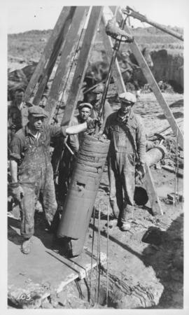
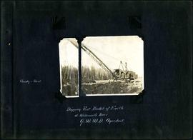
Captions read: Cloudy and sleet - Digging first bucket of earth at Whitemouth River, Greater Winnipeg Water District aqueduct.
Smaill, William

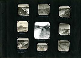
William Smaill Photo Album – Page 10
Part of William Smaill fonds
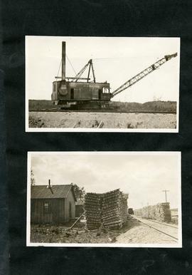
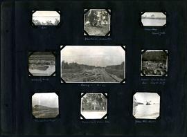
Captions read: Views at Greater Winnipeg Water District gravel pit.
Smaill, William
William Smaill Photo Album – Page 100
Part of William Smaill fonds
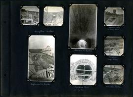
Captions read: Overflow section - Whitemouth syphon - Manhole form at sump well -Reinforcement in overflow - Bulkhead form for syphon - Overflow sump forms - Transition section.
Smaill, William
William Smaill Photo Album – Page 101
Part of William Smaill fonds
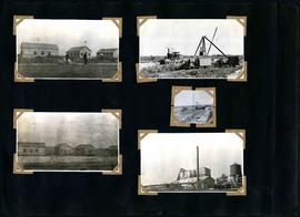
Captions read: Boat house, west bank - excavation for overflow and sump.
Smaill, William
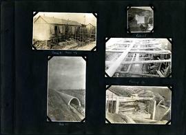
William Smaill Photo Album – Page 102
Part of William Smaill fonds
Captions read: Camp 2, mile 57 - Culvert - Camp 2- Mile 58.
Smaill, William
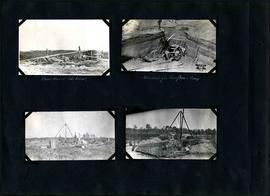
William Smaill Photo Album – Page 104
Part of William Smaill fonds
Captions read: Moving outside forms - Rails to hold sheeting - hand excavation in hardpan -Backfilling - 1st foundation fill - Rock Cut - Hardpan sloughed into trench after rain - Camp 4, mile 71 - Traveller.
Smaill, William
William Smaill Photo Album – Page 105
Part of William Smaill fonds
Captions read: Backfilling, mile 65.
Smaill, William
William Smaill Photo Album – Page 106
Part of William Smaill fonds
Captions read: Dyke - Blanchard's, Indian Bay - Indian Camp, Shoal Lake [Kekekoziibii Shoal Lake 40 First Nation] - Removing arch - Camp 5, mile 77 - Remains after oil House fire, camp 5, mile 77 - Excursion train, camp 6 -Tennis court, Indian Bay - Young wild ducks.
Smaill, William
William Smaill Photo Album – Page 107
Part of William Smaill fonds
Smaill, William
William Smaill Photo Album – Page 108
Part of William Smaill fonds
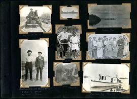
Captions read: My car at mile 38 - Indian Bay - First crew to operate class 7 drag, C. Walgren, operator, [W.H.?] Smaill, fireman - Lassie, Hamish - Fisherman's Tug, Shoal Lake. Also contains a photo showing Kekekoziibii Shoal Lake 40 First Nation in the distance.
Smaill, William
William Smaill Photo Album – Page 14
Part of William Smaill fonds
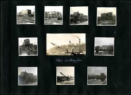
Captions read: Class 14 drag line.
Smaill, William

William Smaill Photo Album – Page 15
Part of William Smaill fonds
Captions read: Anderson's dredge making cut between Indian Bay and Snowshoe Bay.
Smaill, William
William Smaill Photo Album – Page 16
Part of William Smaill fonds
Captions read: J. Nelson, Mrs. Carter, Mrs. Waugh, Miss James, Mr. Cummings, Mayor Waugh, Mrs. Reynolds, W.E. Davis, G.P. Richan, Tom Dunn, Sam Reynolds.
Smaill, William

William Smaill Photo Album – Page 17
Part of William Smaill fonds
Captions read: First bucket on aqueduct - Erection number 3 class 7 at mile 64.
Smaill, William

William Smaill Photo Album – Page 18
Part of William Smaill fonds
Captions read: Class 9 at Oguaka, Iowa - Monighan machine.
Smaill, William