
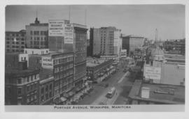
Portage Avenue, Winnipeg, Manitoba
- i01806
- Item
- 1940
Photograph shows view of Paris and Avenue buildings and Bank of Nova Scotia building. Date of photograph is approximate, ca. 1940.
140 results with digital objects Show results with digital objects
Portage Avenue, Winnipeg, Manitoba
Photograph shows view of Paris and Avenue buildings and Bank of Nova Scotia building. Date of photograph is approximate, ca. 1940.
![Logan Avenue and Salter Street [Aerial view]](/uploads/r/city-of-winnipeg-archives-amp-records-control-branch/9/8/0/980f8ba4214d821c9b49366ae35d9ea9ed5b7f44366c5cd894e04befdd6c7a22/C0013_0000_0000_P0018_0033_001_142.jpg)
Logan Avenue and Salter Street [Aerial view]
Inscription (on recto): A161 3-9-43 Logan Ave and Salter St Wp [Winnipeg?] about 4000' 5".
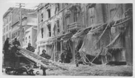

Photograph is one of five photos mounted on page with caption "Assiniboine River flooded, Spring 1916."
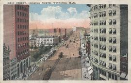
Main Street, looking north, Winnipeg, Man.
Postcard showing Main Street looking north from Bannatyne Avenue. Date of postcard is unknown.

Corner Portage Avenue and Main Street, Winnipeg, Manitoba
Print is a photographic image of the intersection of Portage Avenue and Main Street. Date of print is uncertain, [193-].
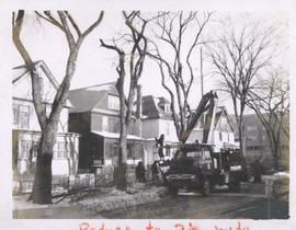
City crews trimming tree branches
Photograph shows city crews trimming tree branches.

The Cove Restaurant, corner of Portage and Carlton
Photograph of "The Cove" Restaurant at 355 Portage Avenue, at Carlton Street. The photograph was taken from a building on Carlton Street looking southeast towards the Eaton's Building, Mitchell-Copp, Zeller's, and the Carlton Building.

Main Street looking northeast to Grace Methodist Church
Photograph of a muddy Main Street in 1871, facing northeast from around St. Mary Avenue. Featured on the photograph's right-hand side is Grace Methodist Church, located at Main Street and Water Avenue (now William Stephenson Way), which was opened on September 17 of that year.

Thoroughfares: Academy Road at Wellington Crescent
View of cars and cyclists heading down Academy Road towards Wellington Crescent and the Maryland Bridge. A small portion of Misericordia Hospital can be seen across the bridge.

Waghorn's Guide map and street index
Part of City Clerk's Library collection
Waghorn's Guide - a small promotional pamphlet published by J.R. Waghorn in 1895. The pamphlet contains a street map of Winnipeg, a street index, and advertisements for various Winnipeg businesses including the Clarendon Hotel, the Redwood Brewery, and the Massey-Harris Company. The map shows the old City of Winnipeg from the Red River on the east to Waverly, Aubrey, and McPhillips Streets on the west, and from Athole Avenue (now Luxton Avenue) in the north to Parker Avenue in the south. Southern Elmwood, Old St. Boniface, and Norwood are also shown on the east side of the river. Railway lines are in black and electric street railway lines are in red.

Notre Dame Avenue facing west from Arlington Street
View of the boulevard on Notre Dame Avenue facing west, between Arlington and McPhillips Streets. Free Press Depot Number 2 can be seen on the right.

Winnipeg, Main Street looking south, Spring of 1874
Part of City of Winnipeg (1874-1971)
Photograph taken from top of Courthouse.

Part of City of Winnipeg (1874-1971)
A photograph of flooding in a residential area of Winnipeg during the 1950 flood. The photograph was taken at the intersection of Disraeli and Euclid.
Harold K. White Studio

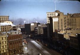
Portage and Main, looking west down Portage Avenue
Photograph of Portage Avenue looking west from the intersection at Main Street. Various shops and business are featured in buildings at Portage and Main that no longer exist, including the towering McArthur/Child's Building on the right. Photograph by Henry Kalen.
Metropolitan Corporation of Greater Winnipeg (Man.). Information Officer

For Your Guidance While in Winnipeg promotional map
Part of Morris Block collection
A promotional map created by the Publicity Bureau of Winnipeg and Manitoba titled "For Your Guidance While in Winnipeg". Map was originally folded as a pamphlet, the front page of which features a graphic of two people driving down Highway 14 (now Highway 75) to Winnipeg. The map is not scale and features cartoon depictions of tourist destinations and landmarks around Winnipeg and St. Boniface. The maps shows major streets, railroads, and street railway lines. The map side was originally framed and cut to fit. At a result a small part of the front page is cut off, including a stamp reading "St. Raphael's Ukrainian Immigrants' Welfare Association of Can[ada]".
Block, Morris

Page shows five street views of Winnipeg, ca. 1903: 1) Main Street from Commercial Club, 2) Elgin Avenue, 3) Geo. Velie, Wholesale Wines and Liquors, 4) William Avenue, looking west, and 5) Main Street, looking north from Portage Avenue.

View of Main Street south from Higgins showing Alberta Hotel
Date of photograph is uncertain, [before 1949].

Photograph shows old St. James Bridge approach, looking north up Madison Street (now Century Street/Route 90). Present Viscount Gort site in center. Date of photograph is uncertain, [after 1932].