A photograph album page with a photograph of storm clouds near the Assiniboine Park Pavilion on the first side and a photograph of the Pergola behind the Pavilion at Assinboine Park on the second side.
A map of the proposed Tuxedo Park residential suburb, specifically the area surrounding the old University of Manitoba campus and Olmsted and Assiniboine Parks. The map shows streets and lots as well as details of the university campus. The map was created by Charles Clifton Chataway (1869-1920) and Bulman Brothers Ltd.
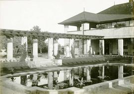
A page from a photograph album. Photograph shows people viewing the pergola behind the former Assiniboine Park Pavilion. Date of photograph is approximate, [ca. 1920].